Kempsford / Chehemeresforde
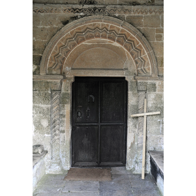
Image copyright © Philip Halling, 2011
CC-BY-SA-2.0
Results: 5 records
view of font and cover
Scene Description: the ca. 1868 font that replaced the now-lost 15th-century Perpendicular one [cf. Font notes]
Copyright Statement: Image copyright © Philip Halling, 2011
Image Source: digital photograph taken 30 April 2011 by Philip Halling [www.geograph.org.uk/photo/2417122] [accessed 21 December 2018]
Copyright Instructions: CC-BY-SA-2.0
view of font and cover in context
![the ca. 1868 font that replaced the now-lost 15th-century Perpendicular one [cf. Font notes]](/static-50478a99ec6f36a15d6234548c59f63da52304e5/compressed/1070106003_compressed.png)
Scene Description: the ca. 1868 font that replaced the now-lost 15th-century Perpendicular one [cf. Font notes]
Copyright Statement: Image copyright © Mary Harris, 2004
Image Source: digital photograph taken in May 2004 by Mary Harris
Copyright Instructions: Standing permission
view of church exterior - south portal
Scene Description: Source caption: "Norman arch of the entrance door to St Mary's church, Kempsford."
Copyright Statement: Image copyright © Philip Halling, 2011
Image Source: digital photograph taken 30 April 2011 by Philip Halling [www.geograph.org.uk/photo/2417122] [accessed 21 December 2018]
Copyright Instructions: CC-BY-SA-2.0
view of church exterior - south porch and portal
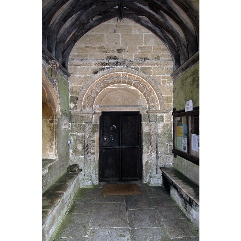
Copyright Statement: Image copyright © John Salmon, 2013
Image Source: digital photograph taken 8 June 2013 by John Salmon [www.geograph.org.uk/photo/3516412] [accessed 21 December 2018]
Copyright Instructions: CC-BY-SA-2.0
view of church exterior - east view
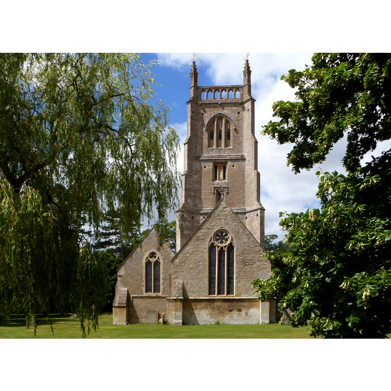
Copyright Statement: Image copyright © John Wilkes, 2014
Image Source: digital photograph taken 14 July 2014 by John Wilkes for BSI
Copyright Instructions: Standing permission
INFORMATION
Font ID: 12493KEM
Object Type: Baptismal Font1
Font Century and Period/Style: 15th century, Perpendicular
Church / Chapel Name: Parish Church of St. Mary
Font Location in Church: [disappeared]
Church Patron Saint(s): St. Mary the Virgin
Church Notes: church originally 12thC; restored 1858 by G.E. Street
Church Address: Kempsford, Gloucestershire GL7 4ET, UK
Site Location: Gloucestershire, South West, England, United Kingdom
Directions to Site: Located off the A361, about halfway between Crcklade and Lechlade
Ecclesiastic Region: Diocese of Gloucester
Historical Region: Hundred of Brightwells Barrow
Additional Comments: disappeared font(s) / replaced font(s) (one (known of) 15thC (probably), and at least one earlier font of the original Norman church here)
Font Notes:
Click to view
There is an entry for Kempsford [variant spelling] in the Domesday survey [http://domesdaymap.co.uk/place/SU1696/kempsford/] [accessed 18 July 2014], but, though a very large place with 69 households, it mentions neither church nor cleric in it. The entry for this parish in the Victoria County History (Gloucester, vol. 7, 1981) notes: "Kempsford had a church by the late 11th century when Ernulf of Hesdin granted it with the tithes and the land of the priest to Gloucester Abbey [...] Most of the Norman nave survives and it retains its north and south doorways and four original windows. [...] A new font was made in 1868, [...] replacing an old octagonal one." The Rev. A. B. Mynors [www.kempsfor.net/history/pdf/history-of-kempsford.pdf] [accessed 6 January 2007] notes in his history of Kempsford [undated -- probably ca. 1960]: "The 15th century font with a plain octagonal bowl which had survived the restoration of the church in 1858 was discarded in 1868 in favour of the present font, carved at Latton by William Rosebalde, and no trace of the Perpendicular one can now be discovered" [NB: according to Mynors [cf. supra] the nave is Norman from ca. 1120, but we have no other information on the original font of this church].
Credit and Acknowledgements: We are grateful to Mary Harris and to John Wilkes for their photographs of church and (new) font.
COORDINATES
UTM: 30U 585195 5724721
Latitude & Longitude (Decimal): 51.667, -1.7681
Latitude & Longitude (DMS): 51° 40′ 1.2″ N, 1° 46′ 5.16″ W
MEDIUM AND MEASUREMENTS
Material: stone
Font Shape: octagonal, mounted
Basin Exterior Shape: octagonal
REFERENCES
- Victoria County History [online], University of London, 1993-. URL: https://www.british-history.ac.uk.