Thornton nr. Leicester
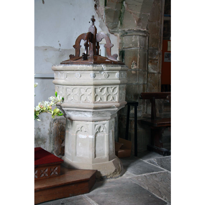
Image copyright © John Salmon, 2012
CC-BY-SA-2.0
Results: 9 records
view of font and cover
Copyright Statement: Image copyright © John Salmon, 2012
Image Source: digital photograph taken 21 August 2012 by John Salmon [www.geograph.org.uk/photo/3132362] [accessed 26 August 2015]
Copyright Instructions: CC-BY-SA-2.0
unidentified
![the original carving scraped off [cf. FontNotes]](/static-50478a99ec6f36a15d6234548c59f63da52304e5/compressed/1151011009_compressed.png)
Scene Description: the original carving scraped off [cf. FontNotes]
Copyright Statement: Image copyright © John Salmon, 2012
Image Source: edited detail of a digital photograph taken 21 August 2012 by John Salmon [www.geograph.org.uk/photo/3132362] [accessed 26 August 2015]
Copyright Instructions: CC-BY-SA-2.0
design element - motifs - roll moulding
Copyright Statement: Image copyright © John Salmon, 2012
Image Source: edited detail of a digital photograph taken 21 August 2012 by John Salmon [www.geograph.org.uk/photo/3132362] [accessed 26 August 2015]
Copyright Instructions: CC-BY-SA-2.0
design element - motifs - quatrefoil - cusped - 16
![[cf. Font notes]](/static-50478a99ec6f36a15d6234548c59f63da52304e5/compressed/1151011008_compressed.png)
Scene Description: [cf. Font notes]
Copyright Statement: Image copyright © John Salmon, 2012
Image Source: edited detail of a digital photograph taken 21 August 2012 by John Salmon [www.geograph.org.uk/photo/3132362] [accessed 26 August 2015]
Copyright Instructions: CC-BY-SA-2.0
design element - motifs - floral - rosette - 16
Copyright Statement: Image copyright © John Salmon, 2012
Image Source: edited detail of a digital photograph taken 21 August 2012 by John Salmon [www.geograph.org.uk/photo/3132362] [accessed 26 August 2015]
Copyright Instructions: CC-BY-SA-2.0
design element - motifs - roll moulding - parallel
Copyright Statement: Image copyright © John Salmon, 2012
Image Source: edited detail of a digital photograph taken 21 August 2012 by John Salmon [www.geograph.org.uk/photo/3132362] [accessed 26 August 2015]
Copyright Instructions: CC-BY-SA-2.0
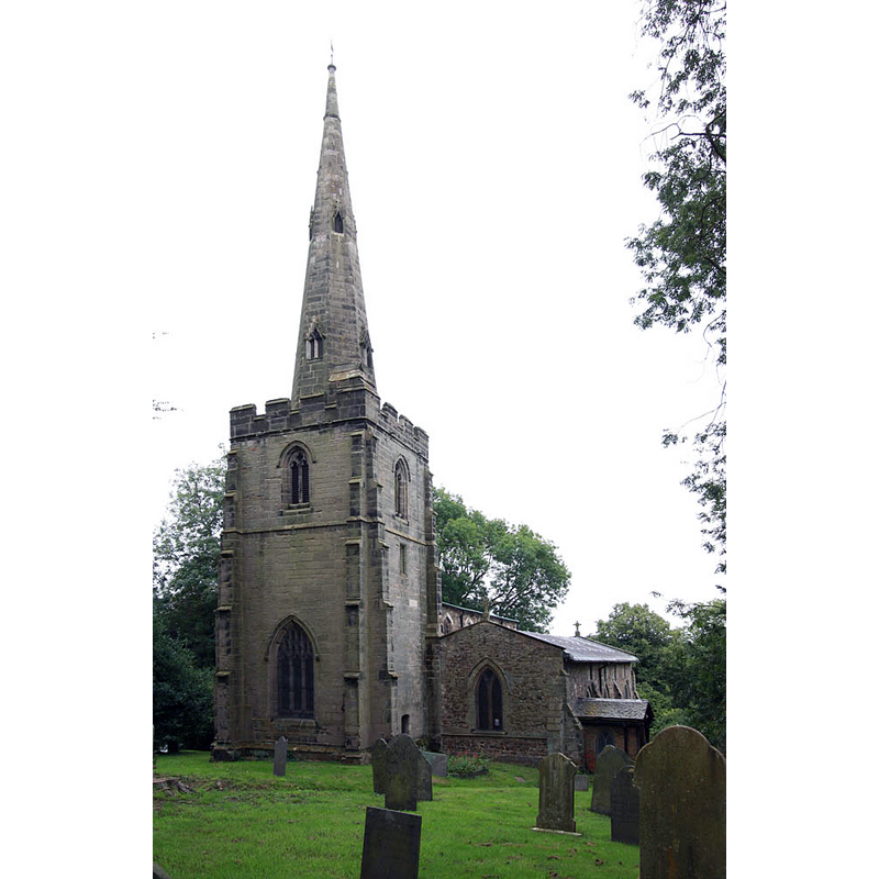
view of church exterior - southwest view
Copyright Statement: Image copyright © John Salmon, 2012
Image Source: digital photograph taken 21 August 2012 by John Salmon [www.geograph.org.uk/photo/3132362] [accessed 26 August 2015]
Copyright Instructions: CC-BY-SA-2.0
design element - architectural - arch or window - trefoiled - 8
Copyright Statement: Image copyright © John Salmon, 2012
Image Source: edited detail of a digital photograph taken 21 August 2012 by John Salmon [www.geograph.org.uk/photo/3132362] [accessed 26 August 2015]
Copyright Instructions: CC-BY-SA-2.0
view of font cover
Copyright Statement: Image copyright © John Salmon, 2012
Image Source: edited detail of a digital photograph taken 21 August 2012 by John Salmon [www.geograph.org.uk/photo/3132362] [accessed 26 August 2015]
Copyright Instructions: CC-BY-SA-2.0
INFORMATION
Font ID: 12434THO
Object Type: Baptismal Font1
Font Century and Period/Style: 15th century, Perpendicular
Church / Chapel Name: Parish Church of St. Peter
Font Location in Church: Inside the church, at the W end
Church Patron Saint(s): St. Peter
Church Address: Thornton, Leicestershire LE67 1AA, UK
Site Location: Leicestershire, East Midlands, England, United Kingdom
Directions to Site: Located off (W) the M1, 12 km WNW of Leicester (access from the B5380, A50)
Ecclesiastic Region: Diocese of Leicester
Additional Comments: recycled font? / composite font? [cf. FontNotes] / damaged font (carving on the underbowl chamfer scraped off; some damage around the upper rim) -- disappeared font? (the one from the original 13thC (?) church here)
Font Notes:
Click to view
No entry for this Thornton found in the Domesday survey. A font here is noted and illustrated in Upcott (1818). Described in Pevsner (1984): "Font. Perp[endicular], octagonal, with the usual panels with quatrefoils, but not arranged in the usual way. Large square feature of stone blocks, the lowest element of a former font base. Once thought to be a maze." The basin has a row of rosettes above, with a row of pointed quatrefoils below, all framed by parallel roll mouldings; the underbowl appears to be a separate block from both basin and base, a case not uncommon in English fonts of the period; it had carving on the chamfered sides, probably cherub heads or foliage, but the carving appears to have been totally scraped off; the roll moulding at the bottom has been retained; the octagonal stem has a trefoiled arch or window on each side; plain splaying lower base, also octagonal. The wooden cover has an almost flat octagonal pyramid base on which is the usual arrangement of four scroll ribs around a centre pivot, with a cross finial; date unknown.
COORDINATES
UTM: 30U 614357 5836268
Latitude & Longitude (Decimal): 52.664281, -1.309005
Latitude & Longitude (DMS): 52° 39′ 51.41″ N, 1° 18′ 32.42″ W
MEDIUM AND MEASUREMENTS
Material: stone
Font Shape: octagonal, mounted
Basin Interior Shape: round
Basin Exterior Shape: octagonal
Drainage System: centre hole in basin
Drainage Notes: lead-lined
LID INFORMATION
Material: wood, oak
Apparatus: no
Notes: [cf. FontNotes]
REFERENCES
- Pevsner, Nikolaus, Leicestershire and Rutland, Harmondsworth: Penguin Books, 1984, p. 405
- Upcott, William, A bibliographical account of the principal works relating to English topography, London: Printed by Richard and Arthur Taylor, 1818, [vol. IV, part II, p. 536 and pl. cxlix / [http://books.google.com/books?id=gLwuAAAAMAAJ&pg=PA228&lpg=PA228&dq=upcott+1818&source=web&ots=lJwT-K00zU&sig=oVT6Kc6G03vqjYf4Synuk_Aek9w#PPP15,M1] [accessed 7 October 2007]