Barnwell St. Andrew / Barnwell Andree / Beornwelle / Bernewell Moyne / Bernewelle Sancti Andree
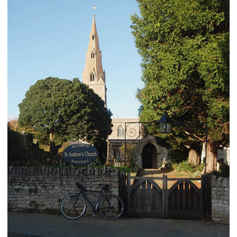
Image copyright © Michael Trolove, 2008
CC-BY-SA-3.0
Results: 3 records
B01: design element - architectural - niche - crocketed and cusped - 7
![[cf. Font notes]](/static-50478a99ec6f36a15d6234548c59f63da52304e5/others/image_not_available.jpg)
Scene Description: [cf. Font notes]
![[cf. Font notes]](/static-50478a99ec6f36a15d6234548c59f63da52304e5/bsi-testing-site/others/image_not_available.jpg)
LB01: design element - motifs - floral
Scene Description: [cf. Font notes]
view of church exterior - south view
Copyright Statement: Image copyright © Michael Trolove, 2008
Image Source: digital photograph taken 24 October 2008 by Michael Trolove [www.geograph.org.uk/photo/1021682] [accessed 16 May 2012]
Copyright Instructions: CC-BY-SA-3.0
INFORMATION
Font ID: 12272BAR
Object Type: Baptismal Font1
Font Century and Period/Style: 14th - 15th century, Perpendicular
Church / Chapel Name: Parish Church of St. Andrew
Font Location in Church: Inside the church
Church Patron Saint(s): St. Andrew
Church Address: Church Hill, Barnwell, Northamptonshire PE8 5PS, UK
Site Location: Northamptonshire, East Midlands, England, United Kingdom
Directions to Site: Located off the A605, just across from Barnwell All Saints, 25 km SW of Peterborough
Ecclesiastic Region: Diocese of Peterborough
Historical Region: Hundred of Polebrook
Additional Comments: unfinished font: one side is blank ; base may have been reset -- disappeared font? (the one from the earlier church here)
Font Notes:
Click to view
Described in the Victoria County History (Northampton, vol. 3, 1930): "There was a priest in Barnwell St. Andrew in 1086 [...] but no direct mention of the church itself seems to be preserved before 1178 when Pope Alexander confirmed to Ramsey Abbey among many other of its possessions Barnwell with its church. [...] No part of the [present] building is older than the 13th century [...] The font is of early 14th century date, and has a richly ornamented bowl with cusped and crocketed niches on seven sides, the west face being blank." Noted in Mee (1945): "The font is beautiful with boldly carved niches." In Pevsner (1973): "Font. Dec[orated]. Octagonal with eight flat crocketed gables and flowers at the foot."
COORDINATES
UTM: 30U 672780 5814367
Latitude & Longitude (Decimal): 52.452122, -0.457282
Latitude & Longitude (DMS): 52° 27′ 7.64″ N, 0° 27′ 26.21″ W
MEDIUM AND MEASUREMENTS
Material: stone
Font Shape: octagonal, mounted
Basin Interior Shape: rectangular
Basin Exterior Shape: octagonal
REFERENCES
- Victoria County History [online], University of London, 1993-. URL: https://www.british-history.ac.uk.
- Mee, Arthur, The King's England: Northamptonshire, country of spires and stately homes, London: Hodder & Stoughton, 1945, [http://northamptoncastle.homeip.net/northampton/books/Arthur%20Mee.htm] [accessed 15 October 2006]