Long Whatton / Watone
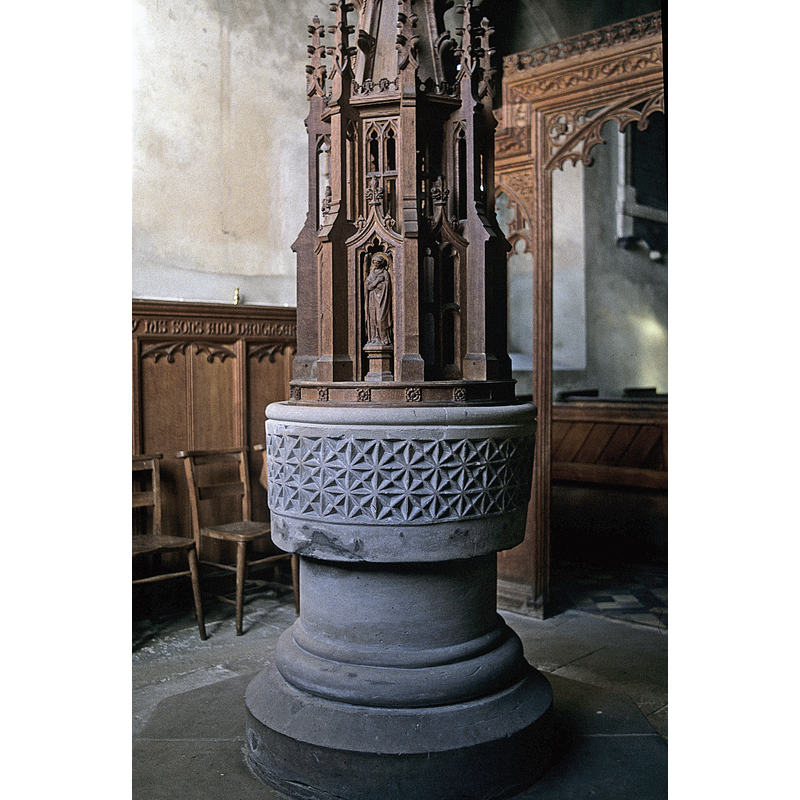
Image copyright © Timothy Marlow, 2015
Image and permission received (letter of 26 October 2013)
Results: 5 records
view of font and cover
Copyright Statement: Image copyright © Timothy Marlow, 2015
Image Source: photograph taken 21 February 1990 by Timothy Marlow
Copyright Instructions: Image and permission received (letter of 26 October 2013)
design element - motifs - roll moulding
Copyright Statement: Image copyright © Timothy Marlow, 2015
Image Source: detail of a photograph taken 21 February 1990 by Timothy Marlow
Copyright Instructions: Image and permission received (letter of 26 October 2013)
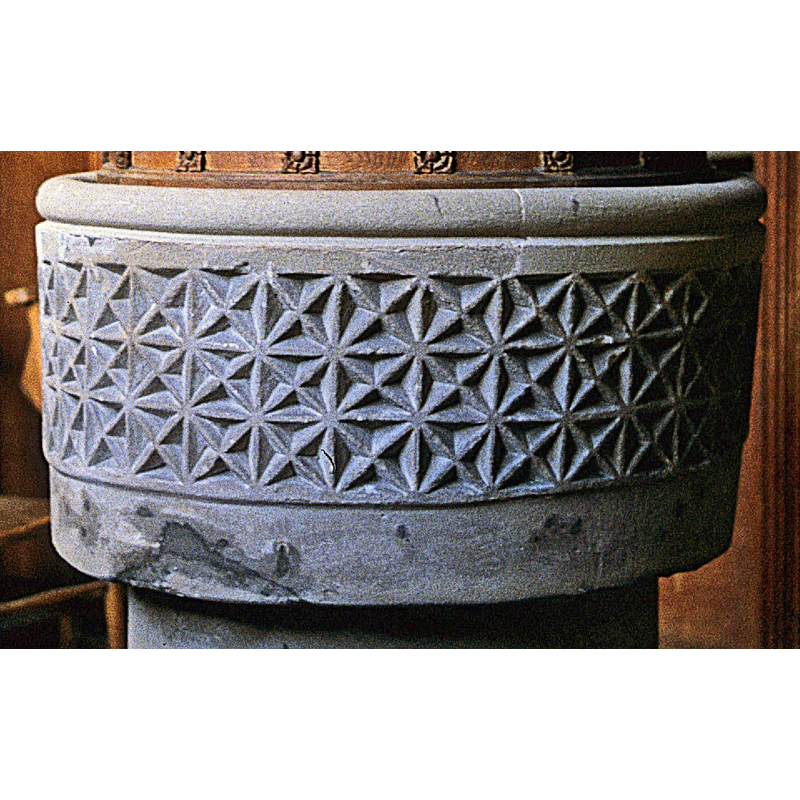
design element - motifs - diaper or nail-head? - in a square
Scene Description: a pattern made of three rows of it, all around the basin
Copyright Statement: Image copyright © Timothy Marlow, 2015
Image Source: detail of a photograph taken 21 February 1990 by Timothy Marlow
Copyright Instructions: Image and permission received (letter of 26 October 2013)
view of church exterior - southeast view
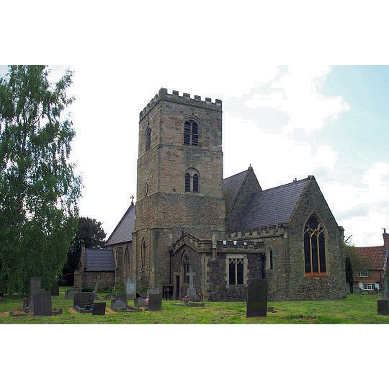
Copyright Statement: Image copyright © Geoff Pick, 2003
Image Source: digital photograph taken 9 May 2003 by Geoff Pick [www.geograph.org.uk/photo/121150] [accessed 4 March 2015]
Copyright Instructions: CC-BY-SA-2.0
design element - motifs - moulding
Copyright Statement: Image copyright © Timothy Marlow, 2015
Image Source: photograph taken 21 February 1990 by Timothy Marlow
Copyright Instructions: Image and permission received (letter of 26 October 2013)
INFORMATION
Font ID: 12257WHA
Object Type: Baptismal Font1
Font Century and Period/Style: 12th century, Late Norman
Church / Chapel Name: Parish Church of All Saints
Font Location in Church: Inside the church
Church Patron Saint(s): All Saints
Church Notes: church restored and partially rebuilt 1866
Church Address: Mill Lane, Long Whatton, Leicestershire LE12 5DR, UK
Site Location: Leicestershire, East Midlands, England, United Kingdom
Directions to Site: Located just below the junction M1-A6, near the county border with Nottinghamshire, 8 km NNW of Loughborough, 28 km NW of Leicester
Ecclesiastic Region: Diocese of Leicester
Historical Region: Hundred of Goscote
Additional Comments: re-tooled? / restored?
Font Notes:
Click to view
Noted and illustrated in Upcott (1818). English Heritage [Listing NGR: SK4823623320] (1962) reports: restored circular C12 font with frieze of diagonally crossed squares, in baptistery surrounded by traceried wooden screens of 1929." Described in Pevsner (1984): "Font. Norman, circular, drum-shaped, with three bands of saltire crosses." The font appears to have been re-tooled [was it also re-mounted?]. The tall wooden cover was probably added in the 1866 restoration and re-building of this church.
Credit and Acknowledgements: We are grateful to Timothy Marlow for his photograph of this font
COORDINATES
UTM: 30U 615539 5851989
Latitude & Longitude (Decimal): 52.8053, -1.286
Latitude & Longitude (DMS): 52° 48′ 19.08″ N, 1° 17′ 9.6″ W
MEDIUM AND MEASUREMENTS
Material: stone
Font Shape: cylindrical, mounted
Basin Interior Shape: round
Basin Exterior Shape: round
LID INFORMATION
Date: modern? / ca. 1866?
Material: wood, oak?
Notes: tall wooden spire of open-work with buttresses, sculptures, pinnacles, etc.; appears modern, probably of the 1866 restoration
REFERENCES
- Pevsner, Nikolaus, Leicestershire and Rutland, Harmondsworth: Penguin Books, 1984, p. 279
- Upcott, William, A bibliographical account of the principal works relating to English topography, London: Printed by Richard and Arthur Taylor, 1818, [vol. III, part II, p. 522 and pl. cxlix / [http://books.google.com/books?id=gLwuAAAAMAAJ&pg=PA228&lpg=PA228&dq=upcott+1818&source=web&ots=lJwT-K00zU&sig=oVT6Kc6G03vqjYf4Synuk_Aek9w#PPP15,M1] [accessed 30 September 2007]