Leicester No. 4 / Ledecestre
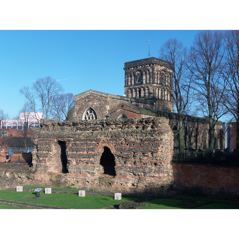
Image copyright © NotFromUtrecht, 2010
CC-BY-SA-3.0
Results: 3 records
view of church exterior in context
Scene Description: showing the northeast view of the church behind the Jewry Wall -- Source caption: "The Jewry Wall and St Nicholas' Church in Leicester, England. The wall is the second largest piece of surviving civil Roman building in Britain, and is both a Scheduled Monument and a Grade I listed building. Originally it separated the Palaestra from the Frigidarium at Ratae Corieltauvorum's baths. St Nicholas' Church is also Grade I listed, and dates from AD 880."
Copyright Statement: Image copyright © NotFromUtrecht, 2010
Image Source: digital photograph taken 8 April 2010 by NotFromUtrecht [https://commons.wikimedia.org/wiki/File:Jewry_Wall_ruins_Apr10.jpg] [accessed 2 September 2015]
Copyright Instructions: CC-BY-SA-3.0
view of church exterior - southwest view
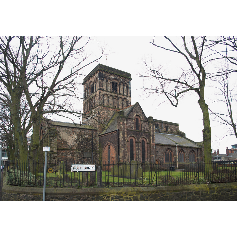
Copyright Statement: Image copyright © NotFromUtrecht, 2010
Image Source: digital photograph taken 8 April 2010 by NotFromUtrecht [https://commons.wikimedia.org/wiki/File:Jewry_Wall_ruins_Apr10.jpg] [accessed 2 September 2015]
Copyright Instructions: CC-BY-SA-3.0
view of font and cover in context
![the modern font [cf. FontNotes]](/static-50478a99ec6f36a15d6234548c59f63da52304e5/compressed/1150926012_compressed.png)
Scene Description: the modern font [cf. FontNotes]
Copyright Statement: Image copyright © Kris1973, 2015
Image Source: digital photograph taken 4 April 2015 by Kris1973 [https://commons.wikimedia.org/wiki/File:Wnętrze_kościoła_od_prawej_strony.jpg] [accessed 2 September 2015]
Copyright Instructions: CC-BY-SA-3.0
INFORMATION
Font ID: 12237LEI
Object Type: Baptismal Font1?
Font Century and Period/Style: 8th - 11th century?, Pre-Conquest
Church / Chapel Name: Parish Church of St. Nicholas
Font Location in Church: [disappeared]
Church Patron Saint(s): St. Nicholas of Myra
Church Address: St. Nicholas Circle, Leicester LE1 4LB, UK
Site Location: Leicestershire, East Midlands, England, United Kingdom
Directions to Site: Located on St. Nicholas Circle, near the inner ring-road
Ecclesiastic Region: Diocese of Leicester
Historical Region: Hundred of Guthlaxton
Additional Comments: disappeared font: or fonts: from ca. 737 on -- req for info on earlier font(s) sent to St Nicholas' churchwarden on 28 Sept 2006 [no reply 2015]
Font Notes:
Click to view
There are ten entries for Leicester [variant spelling] in the Domesday survey [http://opendomesday.org/place/SK5804/leicester/] [accessed 28 August 2015], with a total of four churches mentioned in them. The Victoria County History (Leicester, vol. 4, 1958) notes: "St. Nicholas's Church is probably built on the site of the basilica of Roman Leicester, although it is very difficult to say what lies beneath the church, since only the ground under the narrow passage between the church and the Jewry Wall can be excavated. [...] Any explanation of the foundation and early history of the church must be largely conjectural. It seems very probable that the large early Saxon church which stood on this site was the minster or cathedral of the Saxon see of Leicester. The evidence of the fabric itself does not contradict the possibility that the building of the church coincides with the creation of the see. The first recorded bishop, Cuthwine, is known to have been in office from 679, although the see itself was not permanently established until 737. The church was probably not dedicated to St. Nicholas originally, that dedication only having been adopted about 1220. [...] it seems certain that the church of St. Nicholas, under its old dedication, was given to the college of St. Mary de Castro in 1107 and passed to Leicester Abbey on its foundation in 1143. [...] Whatever the truth of its very early history, it seems certain that the church of St. Nicholas, under its old dedication, was given to the college of St. Mary de Castro in 1107 and passed to Leicester Abbey on its foundation in 1143. [...] The pre-Conquest remains of the church are the north and west walls of the nave and the wall above the 19th-century arch of the south nave arcade. [...] The font stands at the west end of the south aisle, and dates from the last century [...] It is a square block of sandstone, with a scooped basin, supported on a single alabaster column." According to Pevsner (1984) and to the Open Churches Trust [www.openchurchestrust.org.uk] the present font, a 15th-century Perpendicular one, was brought from Stamford St Michael's [cf. Index entry for Stamford No. 1 (Lincs.)]
COORDINATES
UTM: 30U 625807 5833307
Latitude & Longitude (Decimal): 52.635147, -1.140914
Latitude & Longitude (DMS): 52° 38′ 6.53″ N, 1° 8′ 27.29″ W
REFERENCES
- Victoria County History [online], University of London, 1993-. URL: https://www.british-history.ac.uk.
- Pevsner, Nikolaus, Leicestershire and Rutland, Harmondsworth: Penguin Books, 1984, p. 216