Branston / Branston-by-Belvoir / Brantestone
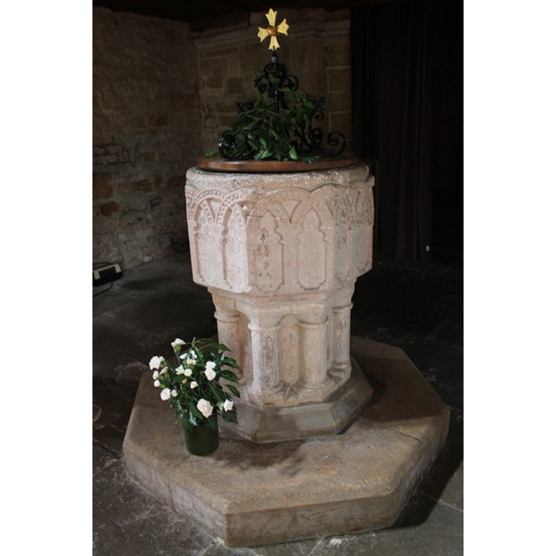
Image copyright © J. Hannan-Briggs, 2012
CC-BY-SA-2.0
Results: 5 records
view of font and cover
Copyright Statement: Image copyright © J. Hannan-Briggs, 2012
Image Source: digital photograph taken 12 August 2012 by J.Hannan-Briggs [www.geograph.org.uk/photo/3107802] [accessed 4 November 2014]
Copyright Instructions: CC-BY-SA-2.0
design element - architectural - arcade - blind - round arches - intersecting arches - beaded-tape motif
Scene Description: [cf. Font notes]
Copyright Statement: Image copyright © J. Hannan-Briggs, 2012
Image Source: digital photograph taken 12 August 2012 by J.Hannan-Briggs [www.geograph.org.uk/photo/3107802] [accessed 4 November 2014]
Copyright Instructions: CC-BY-SA-2.0
view of church exterior - southeast view
![EXT SE digital photograph taken 12 August 2012 by J.Hannan-Briggs [www.geograph.org.uk/photo/3107791] [accessed 4 November 2014]
INT E digital photograph taken 12 August 2012 by J.Hannan-Briggs [www.geograph.org.uk/photo/3107793] [accessed 4 November 2014]
INT W END digital photograph taken 12 August 2012 by J.Hannan-Briggs [www.geograph.org.uk/photo/3107813] [accessed 4 November 2014]
FONT digital photograph taken 12 August 2012 by J.Hannan-Briggs [www.geograph.org.uk/photo/3107802] [accessed 4 November 2014]](/static-50478a99ec6f36a15d6234548c59f63da52304e5/compressed/1141107018_compressed.png)
Scene Description: EXT SE digital photograph taken 12 August 2012 by J.Hannan-Briggs [www.geograph.org.uk/photo/3107791] [accessed 4 November 2014]
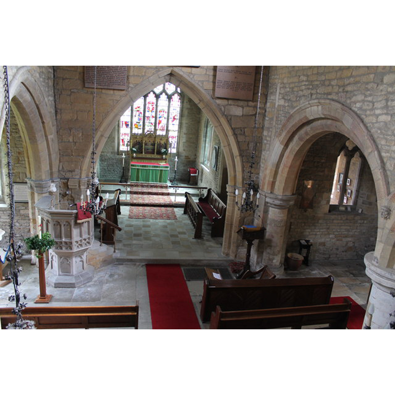
INT E digital photograph taken 12 August 2012 by J.Hannan-Briggs [www.geograph.org.uk/photo/3107793] [accessed 4 November 2014]
INT W END digital photograph taken 12 August 2012 by J.Hannan-Briggs [www.geograph.org.uk/photo/3107813] [accessed 4 November 2014]
FONT digital photograph taken 12 August 2012 by J.Hannan-Briggs [www.geograph.org.uk/photo/3107802] [accessed 4 November 2014]
Copyright Statement: Image copyright © J. Hannan-Briggs, 2012
Image Source: digital photograph taken 12 August 2012 by J.Hannan-Briggs [www.geograph.org.uk/photo/3107791] [accessed 4 November 2014]
Copyright Instructions: CC-BY-SA-2.0
view of font and cover in context
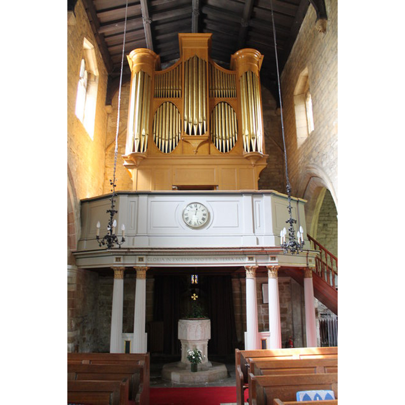
Scene Description: at the west end of the nave, beneath the gallery
Copyright Statement: Image copyright © J. Hannan-Briggs, 2012
Image Source: digital photograph taken 12 August 2012 by J.Hannan-Briggs [www.geograph.org.uk/photo/3107813] [accessed 4 November 2014]
Copyright Instructions: CC-BY-SA-2.0
view of church interior - nave - looking east
Copyright Statement: Image copyright © J. Hannan-Briggs, 2012
Image Source: digital photograph taken 12 August 2012 by J.Hannan-Briggs [www.geograph.org.uk/photo/3107793] [accessed 4 November 2014]
Copyright Instructions: CC-BY-SA-2.0
INFORMATION
Font ID: 12184BRA
Object Type: Baptismal Font1
Font Century and Period/Style: 12th - 13th century, Late Norman
Church / Chapel Name: Parish Church of St. Guthlac
Font Location in Church: Inside the church
Church Patron Saint(s): St. Guthlac [aka Guthlake]
Church Address: Main St, Branston-by-Belvoir, Leicestershire, NG32 1RU, UK
Site Location: Leicestershire, East Midlands, England, United Kingdom
Directions to Site: Located off the A607, NNE of Waltham on the Wolds, in the Vale of Belvoir
Ecclesiastic Region: Diocese of Leicester
Historical Region: Hundred of Framland
Font Notes:
Click to view
There is an entry for this Branston [variant spelling] in the Domesday survey [http://domesdaymap.co.uk/place/SK8129/branston/] [accessed 4 November 2014], but it mentions neither cleric nor church in it. The font in this church is noted in Pevsner (1984): "Font. Norman, octagonal, with intersected beaded arches."
COORDINATES
UTM: 30U 648203 5858623
Latitude & Longitude (Decimal): 52.856908, -0.798772
Latitude & Longitude (DMS): 52° 51′ 24.87″ N, 0° 47′ 55.58″ W
MEDIUM AND MEASUREMENTS
Material: stone
Font Shape: octagonal, mounted
Basin Interior Shape: round
Basin Exterior Shape: octagonal
LID INFORMATION
Date: modern?
Material: wood and metal
Apparatus: no
Notes: round, flat and plain wooden [oak?] platform, with metal scroll-rib openwork and gilded cross finial
REFERENCES
- Pevsner, Nikolaus, Leicestershire and Rutland, Harmondsworth: Penguin Books, 1984, p. 109