Woodton / Udetuna / Undetena / Uuddetuna / Wodetona / Wodetuna / Wooton
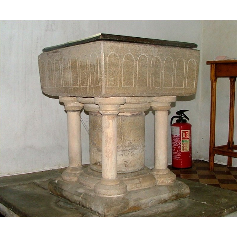
Image copyright © Simon Knott, 2005
Standing permission
Results: 6 records
view of font and cover
Copyright Statement: Image copyright © Simon Knott, 2005
Image Source: digital photograph March 2005 by Simon Knott [www.norfolkchurches.co.uk/woodton/woodton.htm]
Copyright Instructions: Standing permission
design element - architectural - arcade - blind - round arches
Scene Description: seven per side, but probably modern; perhaps the whole basin is modern
Copyright Statement: Image copyright © Simon Knott, 2005
Image Source: digital photograph March 2005 by Simon Knott [www.norfolkchurches.co.uk/woodton/woodton.htm]
Copyright Instructions: Standing permission
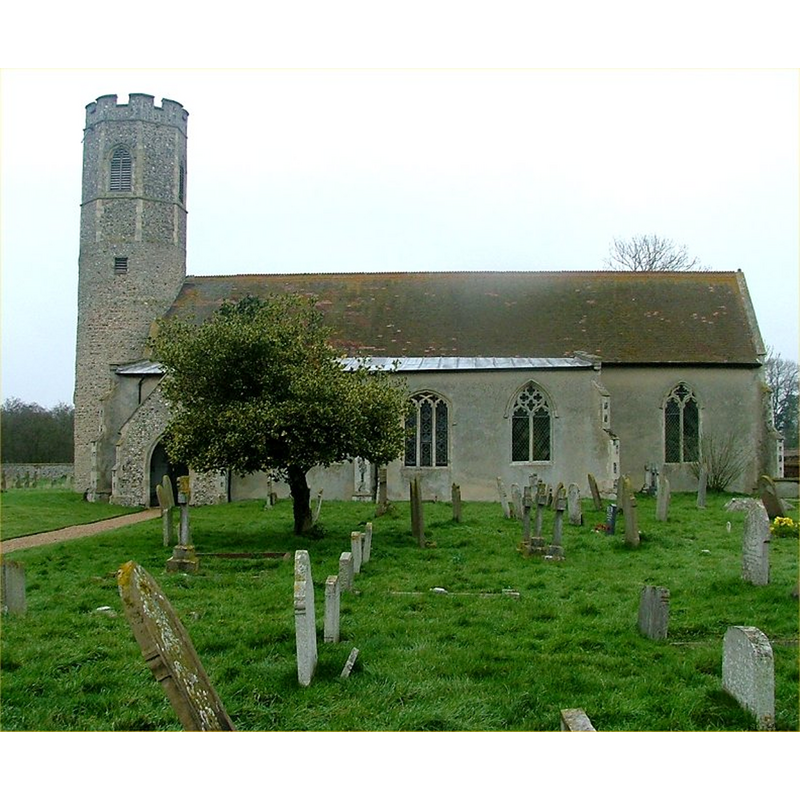
view of church exterior - southwest view
![Photo caption: "Norman round tower" [with a later octagonal storey]](/static-50478a99ec6f36a15d6234548c59f63da52304e5/compressed/1140307047_compressed.png)
Scene Description: Photo caption: "Norman round tower" [with a later octagonal storey]
Copyright Statement: Image copyright © George Plunkett, 2014
Image Source: B&W photograph taken 16 April 1977 by George Plunkett [www.georgeplunkett.co.uk/Norfolk/W/Woodton All Saints church from SW [5770] 1977-04-16.jpg] [accessed 6 March 2014]
Copyright Instructions: Standing permission by Jonathan Plunkett
view of church exterior - south view
Copyright Statement: Image copyright © Simon Knott, 2005
Image Source: digital photograph March 2005 by Simon Knott [www.norfolkchurches.co.uk/woodton/woodton.htm]
Copyright Instructions: Standing permission
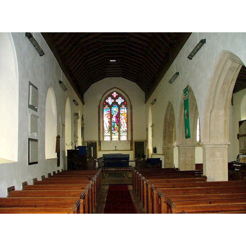
view of church interior - nave - looking east
Copyright Statement: Image copyright © Simon Knott, 2005
Image Source: digital photograph March 2005 taken by Simon Knott [www.norfolkchurches.co.uk/woodton/woodton.htm] [accessed 6 March 2014]
Copyright Instructions: Standing permission
design element - motifs - moulding
Scene Description: forming the capitals and bases of the supporting shafts; some (?) modern
Copyright Statement: Image copyright © Simon Knott, 2005
Image Source: digital photograph March 2005 by Simon Knott [www.norfolkchurches.co.uk/woodton/woodton.htm]
Copyright Instructions: Standing permission
INFORMATION
Font ID: 12137WOO
Object Type: Baptismal Font1
Font Century and Period/Style: 12th - 13th century [re-cut], Late Norman? / Early English? [altered]
Church / Chapel Name: Parish Church of All Saints
Font Location in Church: Inside the church
Church Patron Saint(s): All Saints
Church Notes: round-tower church
Church Address: Church Road, Woodton, Norfolk, NR35 2NB, UK
Site Location: Norfolk, East Anglia, England, United Kingdom
Directions to Site: Located 8 km NNW of Bungay (Suffolk), 16 km SSE of Norwich [Woodton is some times listed under Suffolk; it is located in S Norfolk, near the county border]
Ecclesiastic Region: Diocese of Norwich
Historical Region: Hundred of Loddon
Additional Comments: altered font / restored font (the present font [cf. FontNotes]) -- disappeared font? (the one from the pre-Conquest church here)
Font Notes:
Click to view
There are seven entries for Woodton [variant spelling] in the Domesday survey [http://domesdaymap.co.uk/place/TM2894/woodton/] [accessed 6 March 2014], one of which includes a church with lands in it. Blomefield (1805-1810) notes that the church here was part of the holdings by the freeman Ulketel before the Conquest [NB: Domesday does not acknowledge Anglo-Saxon titles, so earlier lords are 'freemen']; he further notes: "The Church is a rectory dedicated to All-Saints: in the reign of Edward I. Sir James, son of Clereband was patron, and the rector had a manse, with 30 acres of land". The present font is described in Pevsner & Wilson (1999): "C13, of marble, square, with the familiar shallow blank arches, but completely re-cut." Described and illustrated in Knott (2005): "The font is curious. On the face of it is a plain, square Norman affair, it has been reset on elaborate columns and has arcading inscribed into its sides. The result is very pleasing, I think." As it now stands, everything is too sharp, too regular, for a Norman font; the only pieces that appear to have any age patina are the central shaft and the lower half of the lower base. As Knott indicates [cf. supra] it has been reset, and most of the base must be a replacement. The incised arches of the basin are modern work; it may have been re-tooled in all of its outer surfaces [the basin interior needs to be checked for adze or chisel work-patterns to ascertain its age]. The flat and plain square wooden cover is modern.
Credit and Acknowledgements: We are grateful to Simon Knott, of www.norfolkchurches.co.uk, for his photographs of church and font.
COORDINATES
UTM: 31U 389089 5818049
Latitude & Longitude (Decimal): 52.501277, 1.366035
Latitude & Longitude (DMS): 52° 30′ 4.6″ N, 1° 21′ 57.73″ E
MEDIUM AND MEASUREMENTS
Material: stone
Font Shape: square, mounted
Basin Interior Shape: round
Basin Exterior Shape: square
LID INFORMATION
Date: modern
Material: wood
Apparatus: no
Notes: [cf. FontNotes]
REFERENCES
- Blomefield, Francis, An essay towards a topographical history of Norfolk, 1805-1810, vol. 10: 190-193 / [www.british-history.ac.uk/report.aspx?compid=78657] [accessed 6 March 2014]
- Knott, Simon, The Norfolk Churches Site, Simon Knott, 2004. [standing permission to reproduce images received from Simon (February 2005]. URL: www.norfolkchurches.co.uk.
- Pevsner, Nikolaus, Norfolk 2: North-West and South (2nd ed.), London: Penguin, 1999, p. 786