Tring / Threhangre / Tleunge / Trenge / Treunga / Treungula / Triangle
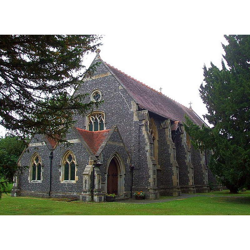
Image copyright © Rob Farrow, 2014
CC-BY-SA-2.0
Results: 4 records
view of church exterior - southwest view
Scene Description: Source caption: "All Saints, Long Marston. This towerless, spireless, little flint-dashed Victorian church serves the village of Long Marston, and replaced the venerable chapel of ease (also All Saints), the tower of which survives"
Copyright Statement: Image copyright © Rob Farrow, 2014
Image Source: digital photograph taken 7 July 2010 by Rob Farrow [www.geograph.org.uk/photo/1954527] [accessed 20 September 2016]
Copyright Instructions: CC-BY-SA-2.0
view of church exterior - tower
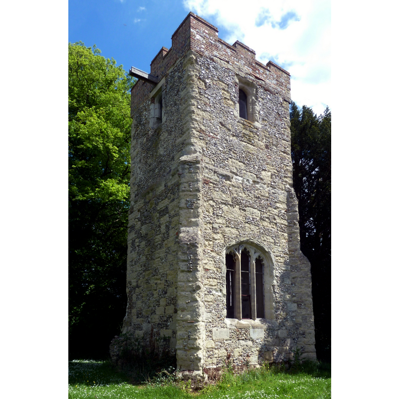
Scene Description: Source caption: "Old Church Tower of All Saints, Long Marston. This C15th tower is all that remains of an ancient Chapel of Ease that dated back to the C12th which was demolished in 1883 as it was in a highly dangerous state of repair. It now stands in its peaceful churchyard"
Copyright Statement: Image copyright © Rob Farrow, 2014
Image Source: digital photograph taken 25 May 2014 by Rob Farrow [www.geograph.org.uk/photo/3997056] [accessed 20 September 2016]
Copyright Instructions: CC-BY-SA-2.0
view of church exterior in context
![Source caption: "Good Friday in Tring […] Service around the Cross in the Churchyard of St Peter & St Paul"](/static-50478a99ec6f36a15d6234548c59f63da52304e5/compressed/1160922004_compressed.png)
Scene Description: Source caption: "Good Friday in Tring […] Service around the Cross in the Churchyard of St Peter & St Paul"
Copyright Statement: Image copyright © Chris Reynolds, 2016
Image Source: digital photograph taken 25 March 2016 by Chris Reynolds [www.geograph.org.uk/photo/4878727] [accessed 20 September 2016]
Copyright Instructions: CC-BY-SA-2.0
view of church interior - nave - looking east
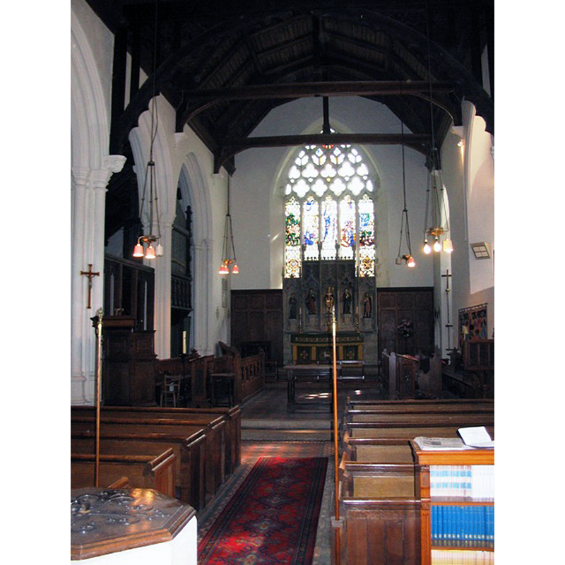
Scene Description: Source caption: "All Saints Church, Long Marston – Interior. At the time it was decided to demolish the old church and build this one there was a major restoration of Tring Parish Church in progress. As a result the clustered columns, high moulded bases and the organ came from Tring." -- the baptismal font is partially visible in the foreground, left side
Copyright Statement: Image copyright © Chris Reynolds, 2006
Image Source: digital photograph taken 9 September 2006 by Chris Reynolds [www.geograph.org.uk/photo/1203191] [accessed 20 September 2016]
Copyright Instructions: CC-BY-SA-2.0
INFORMATION
Font ID: 12001TRI
Object Type: Baptismal Font1
Font Century and Period/Style: 14th - 15th century, Decorated? / Perpendicular?
Church / Chapel Name: New Parish Church of All Saints (new church)
Font Location in Church: Inside the new church
Church Patron Saint(s): [All Saints? -- Lewis (1848) gives the dedication of the old church as St. Peter & St. Paul]
Previous Font Location(s): originally from the Old Church demolished 1883
Church Notes: According to the VCH [cf. FontNotes] Long Marston All Saints' was demolished, except for its 15thC tower, in 1883
Church Address: All Saint's address: Station Road, Tring Rural, Hertfordshire HP23 4QS / St. Peter and St. Paul's address: Tring, Hertfordshire HP23 5BB
Site Location: Hertfordshire, East, England, United Kingdom
Directions to Site: Located off the B4635, N of the A41, E of Drayton Beauchamp, 50 km NW of Hertford, about the same distance WNW of London
Ecclesiastic Region: Diocese of St. Albans
Historical Region: Hundred of Tring [in Domesday] -- Hundred of Dacorum
Additional Comments: altered font (the present font [cf. FontNotes]) -- disappeared font? (the one from the pre-Conquest church here?)
Font Notes:
Click to view
There is an entry for Tring [variant spelling] in the Domesday survey [http://opendomesday.org/place/SP9211/tring/] [accessed 20 September 2016]; it mentions neither cleric nor church in it, but it was until 1066 in the lordship of one Engelric, the priest, which may indicate the presence of a church in it. Lewis' Dictionary of 1848 notes: "the font is in the later English style, higly enriched." The Victoria County History (Hertfordshire, vol. 2, 1908) notes: "The church of Tring belonged to the abbot of Faversham in the reign of Edward I, having, perhaps, been granted to the abbey with the manor […] The church of ST. PETER AND ST. PAUL, TRING […] is in effect a fine fifteenth-century building, much repaired, but in point of size has probably grown very little since the thirteenth century […] The font is modern, and stands under the east arch of the tower." [NB: in the same VCH entry as Tring is included the church of All Saints, Long Marston, which was demolished in 1883 except for its 15thC tower; a font is noted: "The font is ancient, but its octagonal bowl has been cut back, and the necking and shaft alone preserve their old surface, appearing to be of the first half of the fourteenth century."] The Royal Commission on Historical Monuments, Hertforshire (1911) notes: "Font: with octagonal bowl, cut back necking and shaft, apparently 14th-century."
COORDINATES
UTM: 30U 658287 5745072
Latitude & Longitude (Decimal): 51.834012, -0.702656
Latitude & Longitude (DMS): 51° 50′ 2.44″ N, 0° 42′ 9.56″ W
MEDIUM AND MEASUREMENTS
Material: stone
Font Shape: octagonal, mounted
Basin Interior Shape: round
Basin Exterior Shape: octagonal
REFERENCES
- Victoria County History [online], University of London, 1993-. URL: https://www.british-history.ac.uk.
- Great Britain. Royal Commission on Historical Monuments (England), An Inventory of the Historical Monuments in Hertfordshire, London: Printed for His Majesty's Stationary Office by J. Truscott, 1911, p. 223
- Lewis, Samuel, A Topographical Dictionary of England, Comprising the Several Counties, Cities, Boroughs, Corporate and Market Towns, Parishes, Chapelries, and Townships, and the Islands of Guernsy, Jersey, and Man, with Historical and Statistical Descriptions [...], London: S. Lewis, 1831, [www.british-history.ac.uk/report.asp?compid=51354] [accessed 13 March 2007]