Shephall / Escepehala / Escepehale / Scepehale / Schepehale / Sepehale / Shepehall
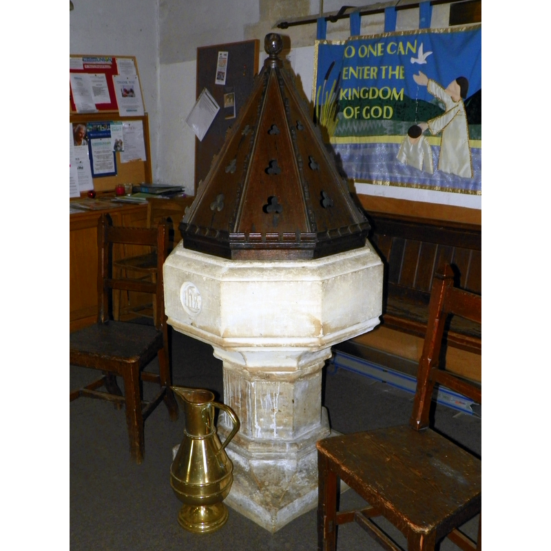
Image copyright © Peter O'Connor [aka anemoneprojectors], 214
CC-BY-SA-2.0
Results: 4 records
view of font and cover
Scene Description: the modern font in use
Copyright Statement: Image copyright © Peter O'Connor [aka anemoneprojectors], 214
Image Source: digital photograph taken 19 February 2014 by Peter O'Connor [aka anemoneprojectors] [www.flickr.com/photos/anemoneprojectors/14834894535] [accessed 4 October 2016]
Copyright Instructions: CC-BY-SA-2.0
view of church exterior - southwest view
![EXT SW digital photograph taken 17 January 2005 by Robin Hall [www.geograph.org.uk/photo/107602] [accessed 4 October 2016]
INT E digital photograph taken in 2013 by Paul Simister [http://stmaryshephall.co.uk/history-of-the-church/st-marys-church-by-paul-simister/] [accessed 4 October 2016] NO KNOWN...
INT W digital photograph taken in 2013 by Paul Simister [http://stmaryshephall.co.uk/history-of-the-church/st-marys-church-by-paul-simister/] [accessed 4 October 2016] NO KNOWN...
MOD FONT digital photograph taken 19 February 2014 by Peter O'Connor [aka anemoneprojectors] [www.flickr.com/photos/anemoneprojectors/14834894535] [accessed 4 October 2016] CC BY-SA 2.0](/static-50478a99ec6f36a15d6234548c59f63da52304e5/compressed/1161004001_compressed.png)
Scene Description: EXT SW digital photograph taken 17 January 2005 by Robin Hall [www.geograph.org.uk/photo/107602] [accessed 4 October 2016]
INT E digital photograph taken in 2013 by Paul Simister [http://stmaryshephall.co.uk/history-of-the-church/st-marys-church-by-paul-simister/] [accessed 4 October 2016] NO KNOWN...
INT W digital photograph taken in 2013 by Paul Simister [http://stmaryshephall.co.uk/history-of-the-church/st-marys-church-by-paul-simister/] [accessed 4 October 2016] NO KNOWN...
MOD FONT digital photograph taken 19 February 2014 by Peter O'Connor [aka anemoneprojectors] [www.flickr.com/photos/anemoneprojectors/14834894535] [accessed 4 October 2016] CC BY-SA 2.0
Copyright Statement: Image copyright © Robin Hall, 2005
Image Source: digital photograph taken 17 January 2005 by Robin Hall [www.geograph.org.uk/photo/107602] [accessed 4 October 2016]
Copyright Instructions: CC-BY-SA-2.0
view of church interior - nave - looking west
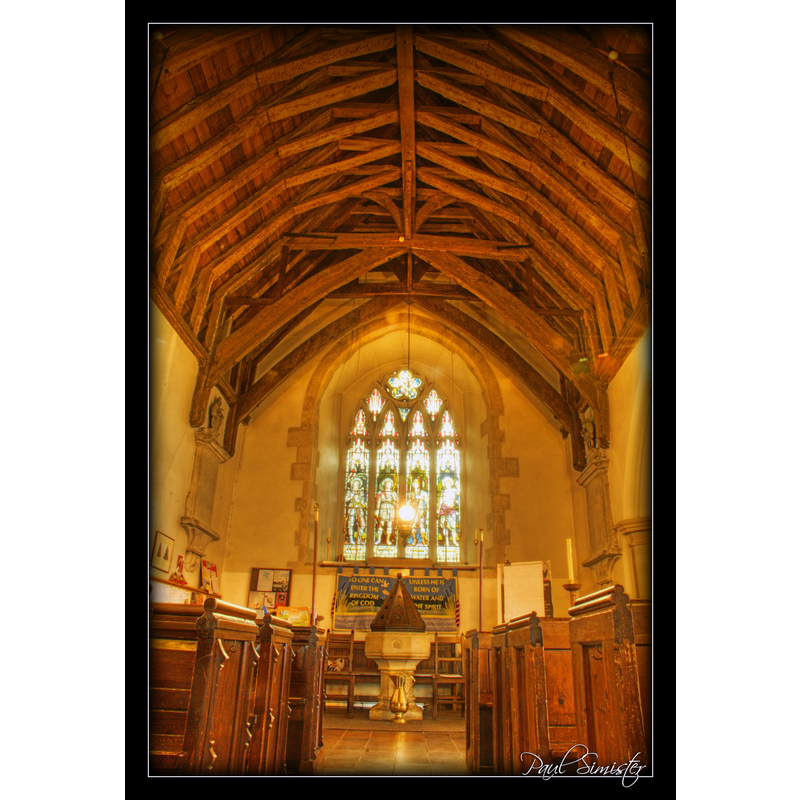
Scene Description: with the modern font and cover at the far end
Copyright Statement: Image copyright © Paul Simister, 2013
Image Source: digital photograph taken in 2013 by Paul Simister [http://stmaryshephall.co.uk/history-of-the-church/st-marys-church-by-paul-simister/] [accessed 4 October 2016]
Copyright Instructions: No known copyright restriction / Fair Dealing
view of church interior - nave - looking east
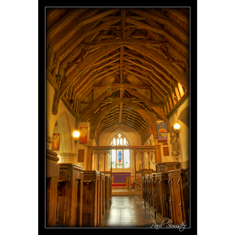
Copyright Statement: Image copyright © Paul Simister, 2013
Image Source: digital photograph taken in 2013 by Paul Simister [http://stmaryshephall.co.uk/history-of-the-church/st-marys-church-by-paul-simister/] [accessed 4 October 2016]
Copyright Instructions: No known copyright restriction / Fair Dealing
INFORMATION
Font ID: 11999SHE
Object Type: Baptismal Font1
Font Century and Period/Style: 12th century, Late Norman
Church / Chapel Name: Parish Church of St. Mary
Font Location in Church: reported in the churchyard ca. 1908
Church Patron Saint(s): St. Mary the Virgin
Church Address: Shephall Green, Shephall, Stevenage, Hertfordshire SG2 9XP, UK
Site Location: Hertfordshire, East, England, United Kingdom
Directions to Site: Located 3 km SE of Stevenage
Ecclesiastic Region: Diocese of St. Albans
Historical Region: Hundred of Broadwater [in Domesday] -- Hundred of Cashio
Additional Comments: abandoned font / disused font / replaced font [cf. FontNotes]
Font Notes:
Click to view
There are two entries for Shephall [variant spelling] in the Domesday survey [http://opendomesday.org/place/TL2522/shephall/] [accessed 3 October 2016], neither of which mentions cleric or church in it. The Victoria County History (Hertfordshire, vol. 2, 1908) notes: "The church of Shephall belonged to the monastery of Reading, but was renounced by them in 1151–4 in favour of the abbey of St. Albans. […] The church was confirmed to the abbey by Pope Honorius III in 1219 […] Externally it shows nothing of age […] Within the church nothing older than the first half of the fourteenth century is to be seen. […] None of the fittings of the church are old, except the chancel screen, which is of the fifteenth century […] The font is modern, and stands at the end of the north aisle, while the old font is set in the churchyard, and is so thickly overgrown with ivy that none of its stonework can be seen." Noted in the Royal Commission on Historical Monuments, Hertfordshire (1911) in much the same terms as in the VCH entry above. An entry in the Transactions of the Hertfordshire Archaeological Society (vol. 9, pt. 1 (1934) reports that "the old font, which is in a very dilapidated condition, may be seen in the churchyard."
COORDINATES
UTM: 30U 694304 5752629
Latitude & Longitude (Decimal): 51.890512, -0.176281
Latitude & Longitude (DMS): 51° 53′ 25.84″ N, 0° 10′ 34.61″ W
MEDIUM AND MEASUREMENTS
Material: stone
REFERENCES
- Victoria County History [online], University of London, 1993-. URL: https://www.british-history.ac.uk.
- Great Britain. Royal Commission on Historical Monuments (England), An Inventory of the Historical Monuments in Hertfordshire, London: Printed for His Majesty's Stationary Office by J. Truscott, 1911, p. 206