Cumnor / Colmanora / Comenore
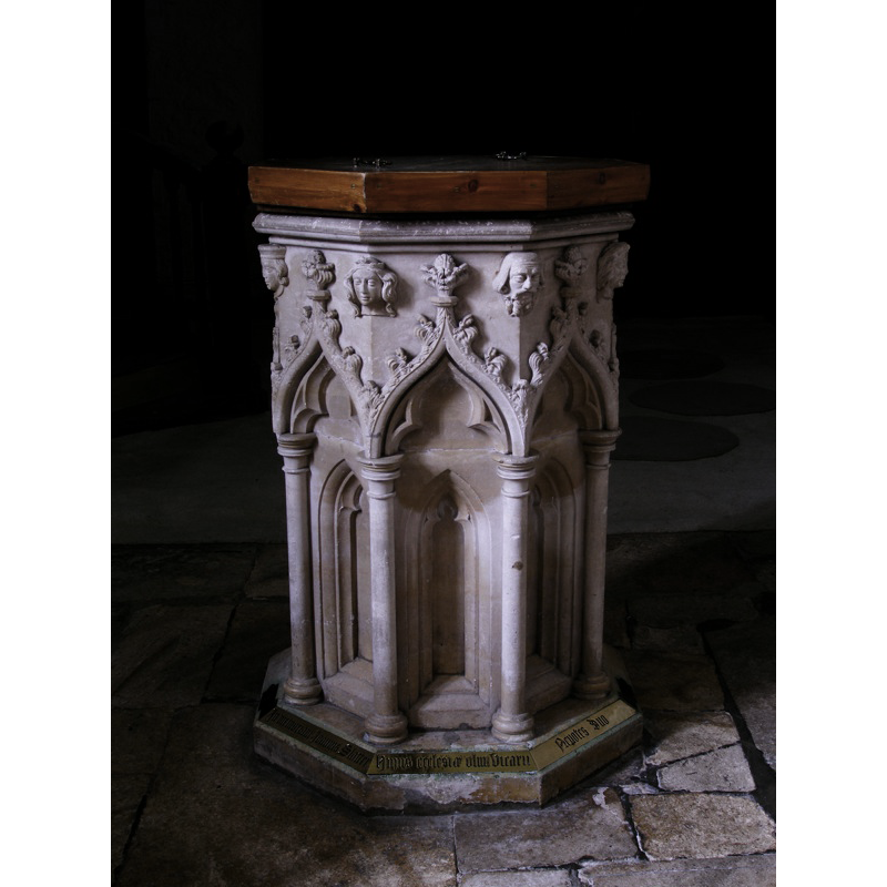
Image copyright © John Ward, 2008
Standing permission
Results: 8 records
view of font and cover
Copyright Statement: Image copyright © John Ward, 2008
Image Source: digital photograph taken 21 April 2008 by John Ward
Copyright Instructions: Standing permission
human figure - head - 8
Copyright Statement: Image copyright © John Ward, 2008
Image Source: digital photograph taken 21 April 2008 by John Ward
Copyright Instructions: Standing permission
design element - motifs - moulding
Copyright Statement: Image copyright © John Ward, 2008
Image Source: digital photograph taken 21 April 2008 by John Ward
Copyright Instructions: Standing permission
design element - architectural - arcade - Ogee arches - crocketed - 8
Scene Description: with deeply-carved trefoil niches
Copyright Statement: Image copyright © John Ward, 2008
Image Source: digital photograph taken 21 April 2008 by John Ward
Copyright Instructions: Standing permission
design element - architectural - window or niche - trefoiled - 8
Copyright Statement: Image copyright © John Ward, 2008
Image Source: digital photograph taken 21 April 2008 by John Ward
Copyright Instructions: Standing permission
view of church interior - looking west
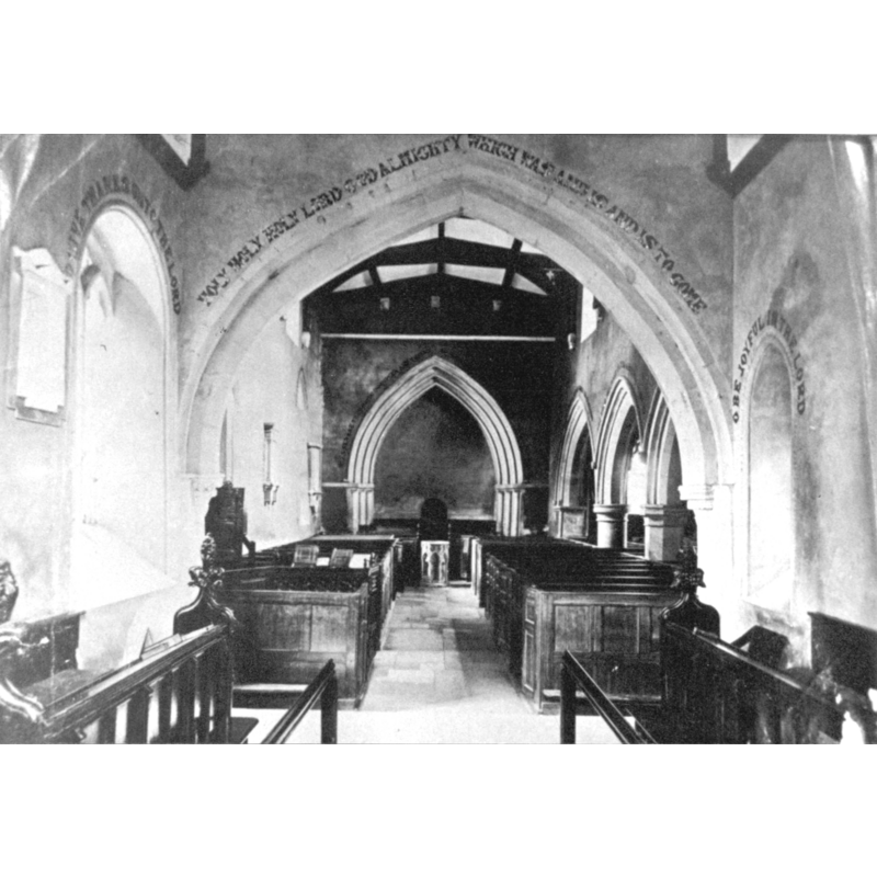
Scene Description: the font is visible at the west end of the nave
Copyright Statement: Image copyright © [in the public domain]
Image Source: B&W photograph ca. 1920 [original source unknown] in www.bodley.ox.ac.ik/external/cumnor/images/002.htm
Copyright Instructions: Assumed PD
inscription
Copyright Statement: Image copyright © John Ward, 2008
Image Source: digital photograph taken 21 April 2008 by John Ward
Copyright Instructions: Standing permission
design element - architectural - column - clustered columns - with capitals and bases - 8
Copyright Statement: Image copyright © John Ward, 2008
Image Source: digital photograph taken 21 April 2008 by John Ward
Copyright Instructions: Standing permission
INFORMATION
Font ID: 11992CUM
Object Type: Baptismal Font1?
Font Century and Period/Style: 11th century, Pre-Conquest? / Norman
Church / Chapel Name: Parish Church of St. Michael
Church Patron Saint(s): St. Michael
Church Address: High Street, Cumnor, Oxfordshire, OX2 9PE, UK
Site Location: Oxfordshire, South East, England, United Kingdom
Directions to Site: Located on the B4017, W of Oxford, 3 km SW of Botley
Ecclesiastic Region: Diocese of Oxford
Historical Region: formerly Berkshire -- Hundred of Hormer
Additional Comments: disappeared font?
Font Notes:
Click to view
There are three entries for Cumnor [variant spelling] in the Domesday survey [http://opendomesday.org/place/SP4604/cumnor/] [accessed 2 June 2015], one of which mentions a church in it. The present font and cover are modern, noted in Howard & Crossley (1919). The Victoria County History (Berkshire, vol. 4, 1924) notes: "There was a church at Cumnor at the time of the Domesday Survey. [...] The west tower and the middle part of the south wall of the nave [of the present church] date from the close of the 12th century." There is no font mentioned in the VCH (ibid.) although it notes the first register for baptisms at this church starting in 1559. The present font is octagonal, of the type without a distinguishable base that was not uncommon in this period in England, but this is a modern version of the old design; the sides are decorated with deeply-carved trefoil niches; the outer perimeter of the niche decorated with crocketed Ogee arches topped with flowery finials; at the upper angles of the basin, just below the rim moulding, human heads, at least one of which is crowned; a band of brass around the lower base chamfer bears a running inscription in Latin [transcription not available] that appears to refer to a former vicar of the Parish and be contemporary with the rest of the font. [NB: we have no information on the medieval font of this church].
Credit and Acknowledgements: We are grateful to John Ward, of Oxfordshire Churches [http://homepage.mac.com/john.ward/oxfordshirechurches], for his photograph of this modern font
COORDINATES
UTM: 30U 615105 5732777
Latitude & Longitude (Decimal): 51.734079, -1.333124
Latitude & Longitude (DMS): 51° 44′ 2.68″ N, 1° 19′ 59.24″ W
LID INFORMATION
Material: wood, oak?
Apparatus: no
Notes: octagonal and flat, but quite thick
REFERENCES
- Victoria County History [online], University of London, 1993-. URL: https://www.british-history.ac.uk.
- Howard, F.E., English Church Woodwork: a Study in Craftmanship during the Mediaeval period A.D. 1250-1550, London: B.T. Batsford, 1919, [http://www.archive.org/stream/englishchurchwoo00howauoft/englishchurchwoo00howauoft_djvu.txt]