Rickmansworth / Prichemareworde / Rickmansworth / Rickmesworth / Rykemersworye / Rykesmaresworth
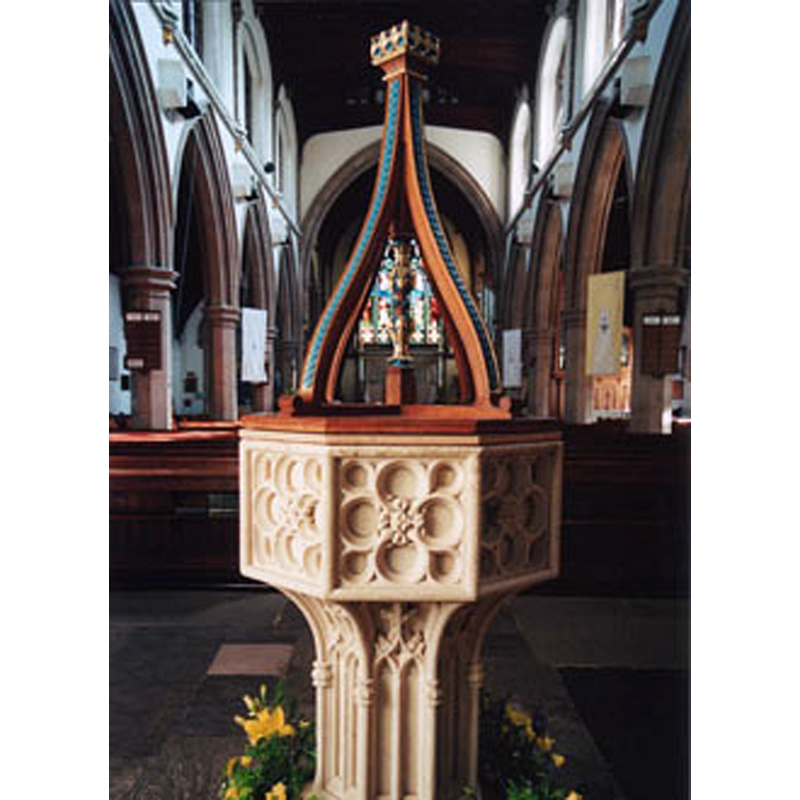
Image copyright © Parish of St Mary, 2016
No known copyright restriction / Fair Dealing
Results: 4 records
view of font and cover in context
Scene Description: the modern font in use seen here at the west end of the nave
Copyright Statement: Image copyright © Parish of St Mary, 2016
Image Source: digital photograph in the Parish web site [www.stmarysrickmansworth.org.uk/0_images/church_tour/church-tour-02.jpg] [accessed 27 September 2016]
Copyright Instructions: No known copyright restriction / Fair Dealing
view of font in context
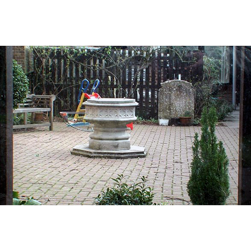
Scene Description: one of the two modern fonts in this church -- Source caption: "St Mary, Rickmansworth, Herts - Garden. With redundant font"
Copyright Statement: Image copyright © John Salmon, 2007
Image Source: digital photograph taken 4 February 2003 by John Salmon [www.geograph.org.uk/photo/350435] [accessed 27 September 2016]
Copyright Instructions: CC-BY-SA-2.0
view of church exterior - southeast view
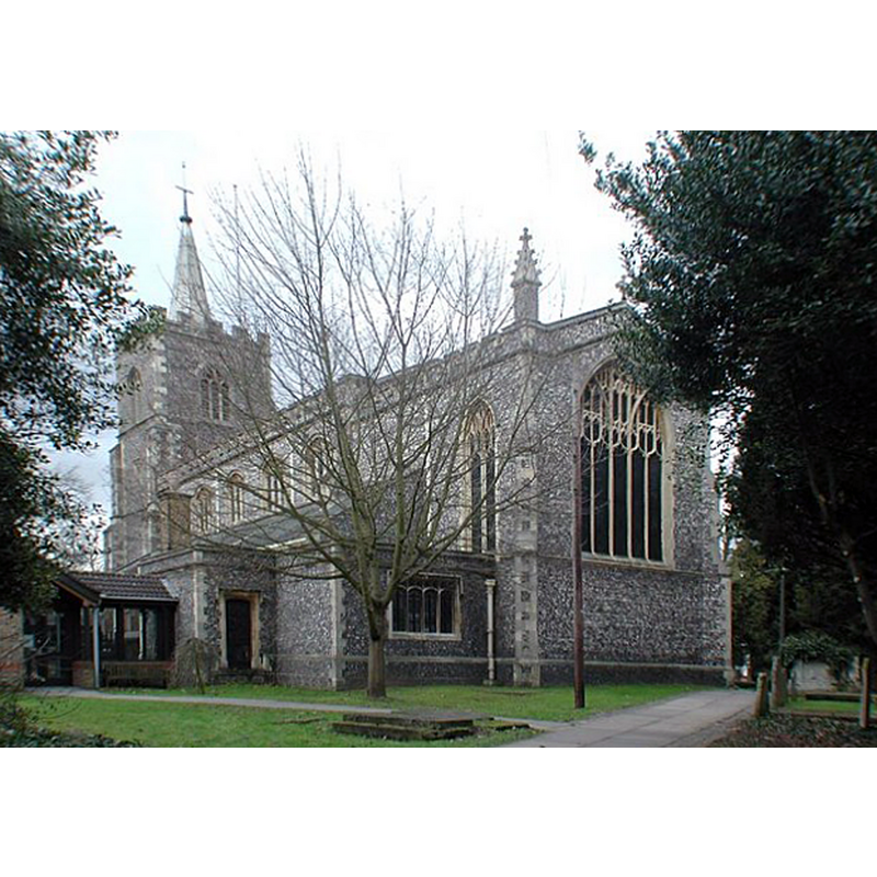
Copyright Statement: Image copyright © John Salmon, 2007
Image Source: digital photograph taken 4 February 2003 by John Salmon [www.geograph.org.uk/photo/350443] [accessed 27 September 2016]
Copyright Instructions: CC-BY-SA-2.0
view of church interior - plan
![[NB: the modern font inside, identified with no. 2, is located at the west end of the nave, placed there in 1890]](/static-50478a99ec6f36a15d6234548c59f63da52304e5/compressed/1160928020_compressed.png)
Scene Description: [NB: the modern font inside, identified with no. 2, is located at the west end of the nave, placed there in 1890]
Copyright Statement: Image copyright © Parish of St Mary, 2016
Image Source: digital image of a plan in the Parish web site [www.stmarysrickmansworth.org.uk/0_images/church_tour/church-plan.jpg] [accessed 27 September 2016]
Copyright Instructions: No known copyright restriction / Fair Dealing
INFORMATION
Font ID: 11987RIC
Object Type: Baptismal Font1?
Font Century and Period/Style: 17th century
Church / Chapel Name: Parish Church of St. Mary
Font Location in Church: Inside the church, SW corner of the nave
Church Patron Saint(s): St. Mary the Virgin
Church Address: Church Street, Rickmansworth, Hertfordshire WD3 1JJ, UK
Site Location: Hertfordshire, East, England, United Kingdom
Directions to Site: Located off (S) the A412, WSW of Watford
Ecclesiastic Region: Diocese of St. Albans
Historical Region: Hundred of St. Albans [in Domesday] -- Hundred of Cashio
Additional Comments: destroyed font? (an earlier font of this church destroyed by Lollard sympathisers) -- MUST USE -- disappeared font? (was the destroyed font the one from the original 12th-13th century church
Font Notes:
Click to view
There is an entry for Rickmansworth [variant spelling] in the Domesday survey [http://opendomesday.org/place/TQ0593/rickmansworth/] [accessed 27 September 2016], but it mentions neither cleric nor church in it. The Victoria County History, Hertfordshire (1908) notes: "The church of Rickmansworth belonged to the abbey of St. Albans, and was confirmed to them by Pope Honorius III in 1219. […] no part of the present building being older than the seventeenth century […] the font, at the south-west of the nave, appears to be of the seventeenth century." In the Royal Commission on Historical Monuments, Hertfordshire (1911) also as a font probably of the 17th-century." Jacques writes in her 'A History of Rickmansworth' [www.rickmansworth-residents-association.org/archive2.html] [accessed 13 July 2006] that, during the stay of Cardinal Wolsey at the Manor of the More in 1530, "the church was deliberately set ablaze by Lollard sympathisers ...]. The christening font was broken up and holy water scattered about the church". The entry for this church in English Heritage [Listing NGR: TQ0613094220] (1951) reports a font of the 19thC at the west end of the nave. The Parish web site [ww.stmarysrickmansworth.org.uk/pdf_general_pages/History of St Mary's Church.pdf] [accessed 27 September 2016] notes: "The fine octagonal, carved stone font, which replaced a hexagonal 17th Century font, was given in memory of Lt Alfred Northey, son of a previous vicar, who was killed in action of 12th October 1914. The oak cover, designed by Sir Charles Nicholson FRIBA , was presented by Rev H Shepherd in 1945." The web site [www.speel.me.uk/chlondon/rickmansworthch.htm] [accessed 27 September 2016] by Bob Speel reports: "the hexagonal font, with base with pairs of blind Gothic lights, dating from early in the 20th Century - another font, octagonal with quatrefoils on the sides, is outside, adjacent to the Church.
[NB: not clear from the sources available what happened to the 17th-century font; a font is
[NB: not clear from the sources available what happened to the 17th-century font; a font is
COORDINATES
UTM: 30U 675225 5723668
Latitude & Longitude (Decimal): 51.636694, -0.467838
Latitude & Longitude (DMS): 51° 38′ 12.1″ N, 0° 28′ 4.22″ W
MEDIUM AND MEASUREMENTS
Material: stone
REFERENCES
- Victoria County History [online], University of London, 1993-. URL: https://www.british-history.ac.uk.
- Great Britain. Royal Commission on Historical Monuments (England), An Inventory of the Historical Monuments in Hertfordshire, London: Printed for His Majesty's Stationary Office by J. Truscott, 1911, p. 170