Ayot St. Lawrence / Aiete / Ayete [Domesday] / Eyott / Great Ayot
![Main image for Ayot St. Lawrence / Aiete / Ayete [Domesday] / Eyott / Great Ayot](/static-50478a99ec6f36a15d6234548c59f63da52304e5/compressed/1161013008_compressed.png)
Image copyright © John Salmon, 2007
CC-BY-SA-2.0
Results: 5 records
view of font
Scene Description: the modern font of the new church
Copyright Statement: Image copyright © John Salmon, 2007
Image Source: digital photograph taken 9 September 2006 by John Salmon [www.geograph.org.uk/photo/376404] [accessed 12 October 2016]
Copyright Instructions: CC-BY-SA-2.0
view of font
Scene Description: the modern font originally from old St. Lawrence, now in the portico of the new church
Copyright Statement: Image copyright © John Salmon, 2007
Image Source: digital photograph taken 9 September 2006 by John Salmon [www.geograph.org.uk/photo/376398] [accessed 12 October 2016]
Copyright Instructions: CC-BY-SA-2.0
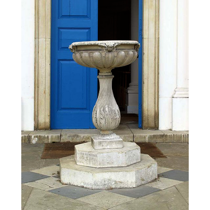
view of church exterior - west view
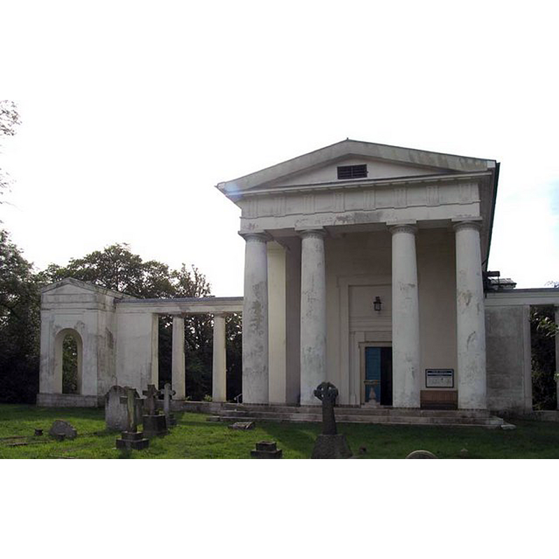
Scene Description: New St. Lawrence; note the baptismal font in the centre of the portico
Copyright Statement: Image copyright © John Salmon, 2007
Image Source: digital photograph taken 9 September 2006 by John Salmon [www.geograph.org.uk/photo/376397] [accessed 12 October 2016]
Copyright Instructions: CC-BY-SA-2.0
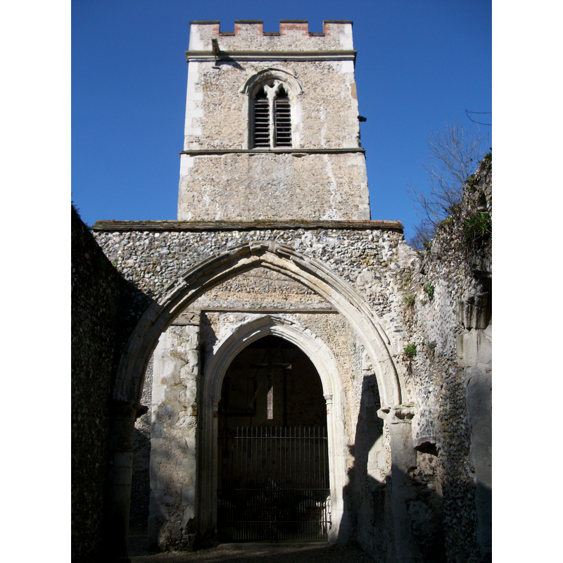
view of church exterior - southeast view
![Old St. Lawrence seen from the southeast; mostly a ruin now
NEW CHURCH EXT W WITH MOD FONT1 digital photograph taken 9 September 2006 by John Salmon [www.geograph.org.uk/photo/376397] [accessed 12 October 2016]
NEW CHURCH MOD FONT1 digital photograph taken 9 September 2006 by John Salmon [www.geograph.org.uk/photo/376398] [accessed 12 October 2016]
NEW CHURCH MOD FONT2 digital photograph taken 9 September 2006 by John Salmon [www.geograph.org.uk/photo/376404] [accessed 12 October 2016]](/static-50478a99ec6f36a15d6234548c59f63da52304e5/compressed/1161013004_compressed.png)
Scene Description: Old St. Lawrence seen from the southeast; mostly a ruin now
NEW CHURCH EXT W WITH MOD FONT1 digital photograph taken 9 September 2006 by John Salmon [www.geograph.org.uk/photo/376397] [accessed 12 October 2016]
NEW CHURCH MOD FONT1 digital photograph taken 9 September 2006 by John Salmon [www.geograph.org.uk/photo/376398] [accessed 12 October 2016]
NEW CHURCH MOD FONT2 digital photograph taken 9 September 2006 by John Salmon [www.geograph.org.uk/photo/376404] [accessed 12 October 2016]
Copyright Statement: Image copyright © Brian Chadwick, 2013
Image Source: digital photograph taken 20 February 2013 by Brian Chadwick [www.geograph.org.uk/photo/3343586] [accessed 12 October 2016]
Copyright Instructions: CC-BY-SA-2.0
view of church interior - nave - looking west
Scene Description: Source caption: "Inside the old church, Ayot St. Lawrence. Beyond the high metal fence in the tower there are two effigies of knights, and a steel ladder with access to the bellfry."
Copyright Statement: Image copyright © Matthew Hatton, 2012
Image Source: digital photograph taken 25 Match 2012 by Matthew Hatton [www.geograph.org.uk/photo/2872696] [accessed 12 October 2016]
Copyright Instructions: CC-BY-SA-2.0
INFORMATION
Font ID: 11948AYO
Object Type: Baptismal Font1
Font Century and Period/Style: 15th century (early?), Perpendicular
Church / Chapel Name: Old Church of St. Lawrence [now derelict]
Font Location in Church: In the church ca. 1911-1912 [cf. FontNotes]
Church Patron Saint(s): St. Lawrence [aka Laurence]
Church Address: Hill Farm Lane, Ayot St Lawrence, Hertfordshire AL6 9BU, UK
Site Location: Hertfordshire, East, England, United Kingdom
Directions to Site: Located halfway between Codicote (SW) and Wheathampstead (NE), SW of Stevenage
Ecclesiastic Region: Diocese of St. Albans
Historical Region: Hundred of Broadwater
Additional Comments: damaged font (the present font, "much broken") -- disappeared font? (the one from the 12thC church here)
Font Notes:
Click to view
There are two entries for Ayot [St Lawrence] [variant spelling] in the Domesday survey [http://opendomesday.org/place/TL1916/ayot-st-lawrence/] [accessed 12 October 2016, neither of which mention cleric or church in it. The Royal Commission on Historical Monuments, Hertforshire (1911) notes: "Font: octagonal, much broken, with a panelled bowl, early 15th-century." The Victoria County History (Hertfordshire , vol 3, 1912) notes: "The church of Ayot St. Lawrence is first mentioned in the Taxation made by Pope Nicholas IV in 1291 […] The old church […] has now fallen into disrepair, having been somewhat unnecessarily superseded in 1779 by the present parish church. It consisted originally of a chancel and nave built probably in the 12th century. […] The church is now roofless, with the exception of the tower […] The font, which is very much broken, is of early 15th-century date, and has an octagonal panelled bowl. […] The modern church of ST. LAWRENCE in Ayot Park was built in 1778 by Sir Lionel Lyde, bart., and consecrated in 1779." There are now two modern fonts in new St. Lawrence's, both modern; one is located in the open portico at the west end of the new church; the other, presumably in use and also modern, is located inside the church. [NB: we have found no photographic evidence to confirm that the battered 15th-century font is still around].
COORDINATES
UTM: 30U 688364 5746626
Latitude & Longitude (Decimal): 51.838633, -0.265762
Latitude & Longitude (DMS): 51° 50′ 19.08″ N, 0° 15′ 56.74″ W
MEDIUM AND MEASUREMENTS
Material: stone
Font Shape: octagonal, mounted
Basin Interior Shape: round
Basin Exterior Shape: octagonal
REFERENCES
- Victoria County History [online], University of London, 1993-. URL: https://www.british-history.ac.uk.
- Great Britain. Royal Commission on Historical Monuments (England), An Inventory of the Historical Monuments in Hertfordshire, London: Printed for His Majesty's Stationary Office by J. Truscott, 1911, p. 43