Lilley / Linlea / Linlee / Linlega / Linlegh / Linlei / Lylle / Lylly / Lyndley / Lyngeleye / Lynley / Lynleye
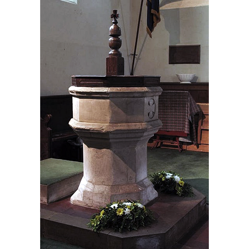
Image copyright © John Salmon, 2007
CC-BY-SA-2.0
Results: 6 records
view of font and cover
Copyright Statement: Image copyright © John Salmon, 2007
Image Source: digital photograph taken 18 May 2007 by John Salmon [www.geograph.org.uk/photo/472199] [accessed 12 October 2016]
Copyright Instructions: CC-BY-SA-2.0
design element - motifs - moulding
Copyright Statement: Image copyright © John Salmon, 2007
Image Source: digital photograph taken 18 May 2007 by John Salmon [www.geograph.org.uk/photo/472199] [accessed 12 October 2016]
Copyright Instructions: CC-BY-SA-2.0
symbol - cross - Greek - in a circle
Scene Description: on the east side of the font
Copyright Statement: Image copyright © John Salmon, 2007
Image Source: digital photograph taken 18 May 2007 by John Salmon [www.geograph.org.uk/photo/472199] [accessed 12 October 2016]
Copyright Instructions: CC-BY-SA-2.0
design element - motifs - moulding - graded
Copyright Statement: Image copyright © John Salmon, 2007
Image Source: digital photograph taken 18 May 2007 by John Salmon [www.geograph.org.uk/photo/472199] [accessed 12 October 2016]
Copyright Instructions: CC-BY-SA-2.0
view of church exterior - southeast view
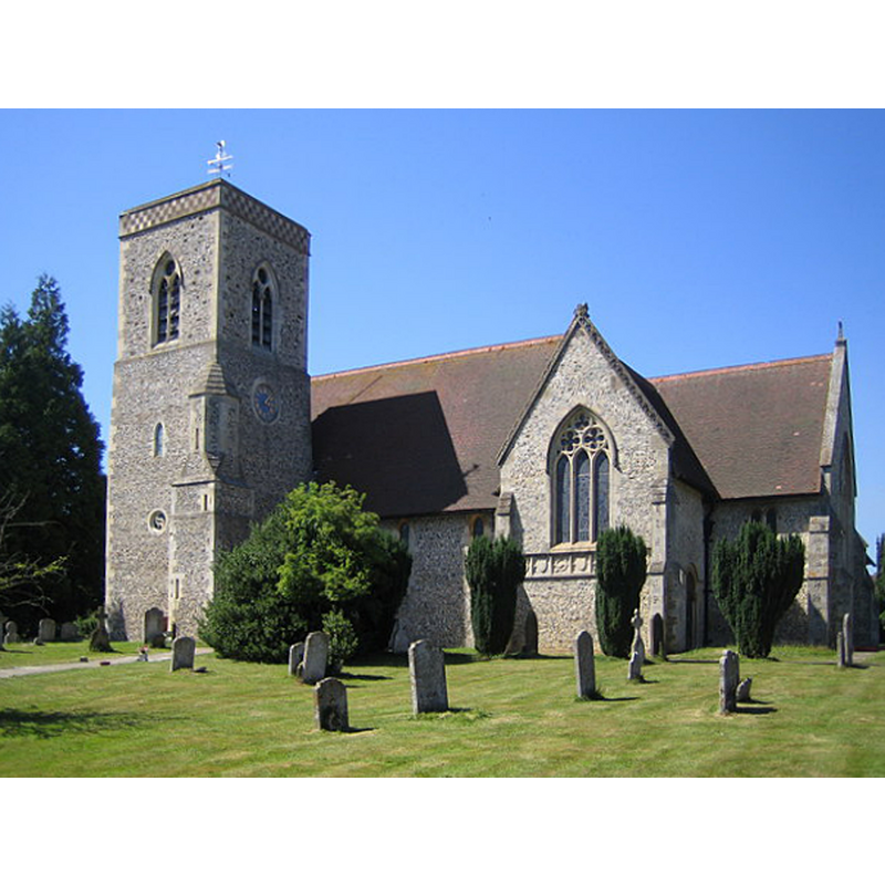
Copyright Statement: Image copyright © Nigel Cox, 2006
Image Source: digital photograph taken 15 July 2006 by Nigel Cox [www.geograph.org.uk/photo/202359] [accessed 12 October 2016]
Copyright Instructions: CC-BY-SA-2.0
view of church interior - nave - looking east
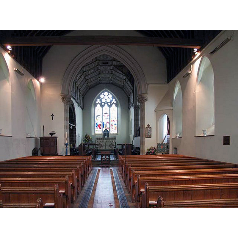
Copyright Statement: Image copyright © John Salmon, 2007
Image Source: digital photograph taken 18 May 2007 by John Salmon [www.geograph.org.uk/photo/472197] [accessed 12 October 2016]
Copyright Instructions: CC-BY-SA-2.0
INFORMATION
Font ID: 11929LIL
Object Type: Baptismal Font1
Font Century and Period/Style: 15th century, Perpendicular
Church / Chapel Name: Parish Church of St. Peter
Font Location in Church: Inside the church, at the W end of the nave
Church Patron Saint(s): St. Peter
Church Address: Lilley Bottom Road, Lilley, Hertfordshire LU2 8LN
Site Location: Hertfordshire, East, England, United Kingdom
Directions to Site: Located between Hitchin (8 km WSW) and Luton (7 km NNE), by the county border with Bedford
Ecclesiastic Region: Diocese of St. Albans
Historical Region: Hundred of Hitchin
Additional Comments: disappeared font? (the one from the Domesday-time church here)
Font Notes:
Click to view
There is an entry for Lilley [variant spelling] in the Domesday survey [http://opendomesday.org/place/TL1126/lilley/] [accessed 12 October 2016]; it mentions a priest but not a church, though there must have been one in it. The Royal Commission on Historical Monuments, Hertfordshire (1911) has: "Font: octagonal, of clunch,15th-century." The Victoria County History (Hertsfordshire, vol. 3, 1912) notes: "The earliest record of the advowson of the church of Lilley is in the year 1213, at which date it was in the king's hands, with other property of the Normans […] The parish church of ST. PETER, which stands in the village, was originally built in the 12th century. It was, however, wholly rebuilt in 1871, a few portions of the old church and some fittings being retained in the new building. […] The font, of the 15th century, is octagonal and of clunch." The entry for this church in English Heritage [Listing NGR: TL1183226370] (1968) reports: "At W end of nave C15 octagonal clunch font with thick shaft, moulded corbel stage to plain bowl with sunk cross on E face. Moulded projecting rim. Flat octagonal
wooden cover with moulded edge and fat turned finial with 3 dimensional cross on top." In Pevsner & Cherry (1977) as a 15th-century font from the medieval church, that survived the restoration of 1870-1871.
wooden cover with moulded edge and fat turned finial with 3 dimensional cross on top." In Pevsner & Cherry (1977) as a 15th-century font from the medieval church, that survived the restoration of 1870-1871.
COORDINATES
UTM: 30U 680455 5755840
Latitude & Longitude (Decimal): 51.924, -0.37562
Latitude & Longitude (DMS): 51° 55′ 26.4″ N, 0° 22′ 32.23″ W
MEDIUM AND MEASUREMENTS
Material: stone, limestone (clunch)
Font Shape: octagonal, mounted
Basin Interior Shape: round
Basin Exterior Shape: octagonal
LID INFORMATION
Material: wood
Apparatus: no
Notes: [cf. FontNotes]
REFERENCES
- Victoria County History [online], University of London, 1993-. URL: https://www.british-history.ac.uk.
- Great Britain. Royal Commission on Historical Monuments (England), An Inventory of the Historical Monuments in Hertfordshire, London: Printed for His Majesty's Stationary Office by J. Truscott, 1911, p. 142
- Pevsner, Nikolaus, Hertfordshire, Harmondsworth: Penguin Books, 1977, p. 235