Clothall / Cladhele / Clahall / Clohall / Clothalle
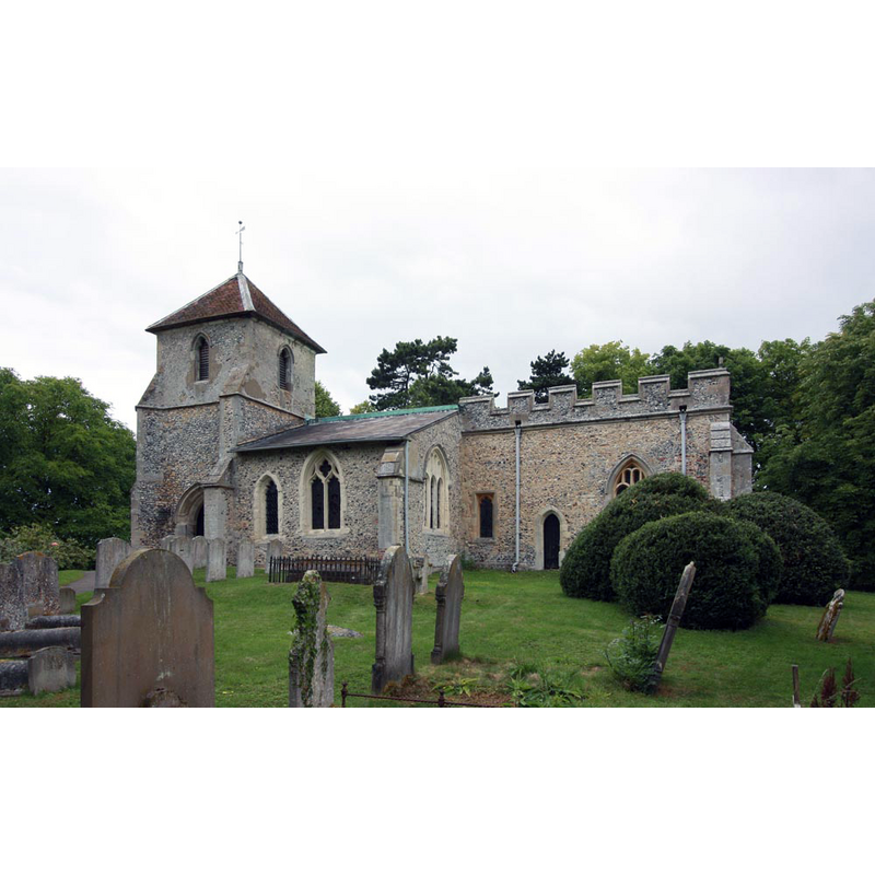
Image copyright © John Salmon, 2011
CC-BY-SA-2.0
Results: 3 records
view of church exterior - southeast view
Copyright Statement: Image copyright © John Salmon, 2011
Image Source: digital photograph taken 21 June 2011 by John Salmon [www.geograph.org.uk/photo/2474015] [accessed 20 October 2016]
Copyright Instructions: CC-BY-SA-2.0
design element - architectural - arcade - blind - round arches
![[cf. Font notes]](/static-50478a99ec6f36a15d6234548c59f63da52304e5/others/permission_not_available.jpg)
Scene Description: [cf. Font notes]
Copyright Statement: Image copyright © The Corpus of Romanesque Sculpture in Britain and Ireland, 2016
Image Source: digital image of a photograph in the CRSBI [www.crsbi.ac.uk/site/786/] [accessed 20 October 2016]
Copyright Instructions: PERMISSION NOT AVAILABLE -- IMAGE NOT FOR PUBLIC USE
design element - motifs - moulding
Scene Description: notice the modern replacement colonnettes
Copyright Statement: Image copyright © The Corpus of Romanesque Sculpture in Britain and Ireland, 2016
Image Source: digital image of a photograph in the CRSBI [www.crsbi.ac.uk/site/786/] [accessed 20 October 2016]
Copyright Instructions: PERMISSION NOT AVAILABLE -- IMAGE NOT FOR PUBLIC USE
INFORMATION
Font ID: 11915CLO
Object Type: Baptismal Font1
Font Century and Period/Style: 12th century, Late Norman
Church / Chapel Name: Parish Church of St. Mary the Virgin
Font Location in Church: Inside the church
Church Patron Saint(s): St. Mary the Virgin
Church Address: Ashanger Lane, Clothall, Hertfordshire SG7 6RE, UK
Site Location: Hertfordshire, East, England, United Kingdom
Directions to Site: Located off (W) the A507, 3.5 km SE of Baldock
Ecclesiastic Region: Diocese of St. Albans
Historical Region: Hundred of Odsey
Additional Comments: altered font (the outer colonnettes of the base are a modern replacement) -- disappeared font? (was there a church here in 1066, as suggested by the lordship a priest in Domesday?)
Font Notes:
Click to view
There are four entries for Clothall [variant spelling] in the Domesday survey [http://opendomesday.org/place/TL2731/clothall/] [accessed 20 October 2016], neither of which mentions a church in it; a priest named Thorbert was lord on one part in 1066, which may indicate that a church existed there at the time. The Royal Commission on Historical Monuments, Hertforshire (1911) reports: "Font: 12th-century, of Purbeck marble, with square basin ornamented with shallow round-headed panels, and carried upon five circular shafts with a moulded base; cover, 17th-century." The Victoria County History (Hertfordshire, vol. 3, 1912) notes: "The earliest known record of Clothall Church is the presentation of a rector in 1237 by Simon de Clothall, lord of the manor. [...] The present church appears to have been erected c. 1350–70 on the foundations of the older one or the older stones re-used, as some of the lower stones are of shelly oolite, the rest of the stonework being of clunch. [...] The font is of the 12th century. It is of Purbeck marble, and has a square basin carried upon a large central shaft, with a smaller shaft at each angle; the bases are moulded and rest on a square plinth. On each face of the basin are four shallow round-headed panels. The 17th-century cover is of wood." In Pevsner & Cherry (1977): "Font: C12, of the table-top type, Purbeck marble, square, with shallow blank round-headed arches." Described and illustrated by Hazel Gardiner in the CRSBI (2016): "An earlier church probably existed on this site, but the only 12thc. feature now present is the font. [...] The font has a square bowl supported on angle colonnettes and a central thicker column. The colonnettes have flattened bulbous bases with merge with the base of the central column. The bases are very damaged, only the NE angle is unrepaired. This monolithic structure is supported on a chamfered plinth comprising a number of shaped stones. Each face of the font is carved with four shallow bays of arcading. The colonnettes are modern. The bowl, base and central support are Purbeck Marble (or possibly Sussex Marble). The font has been damaged and the upper part of the bowl (now repaired with cement) had broken completely away from the bowl. Part of the S side has been restored at the top. Lead lined." Noted in Leach (1975) as a font made of Purbeck marble, without further details [source given: RCHM, 1910].
COORDINATES
UTM: 30U 695668 5761771
Latitude & Longitude (Decimal): 51.97213, -0.15128
Latitude & Longitude (DMS): 51° 58′ 19.67″ N, 0° 9′ 4.61″ W
MEDIUM AND MEASUREMENTS
Material: stone, limestone (Purbeck or Sussex marble)
Font Shape: square, mounted
Basin Interior Shape: round
Basin Exterior Shape: square
Drainage Notes: lead-lined
Basin Depth: 21 cm*
Basin Total Height: 28 cm*
Font Height (less Plinth): 71 cm*
Trapezoidal Basin: 64 x 64 cm*
Notes on Measurements: * CRSBI (2016)
LID INFORMATION
Date: 17th century?
Material: wood, oak?
Notes: [cf. FontNotes]
REFERENCES
- Victoria County History [online], University of London, 1993-. URL: https://www.british-history.ac.uk.
- Corpus of Romanesque Sculpture in Britain and Ireland, The Corpus of Romanesque Sculpture in Britain and Ireland, The Corpus of Romanesque Sculpture in Britain and Ireland. URL: http://www.crsbi.ac.uk.
- Great Britain. Royal Commission on Historical Monuments (England), An Inventory of the Historical Monuments in Hertfordshire, London: Printed for His Majesty's Stationary Office by J. Truscott, 1911, p. 81
- Leach, Rosemary, A Investigation into the use of Purbeck Marble in Medieval England, Hartlepool: E.W. Harrisons & Sons, 1975, p. 70
- Pevsner, Nikolaus, Hertfordshire, Harmondsworth: Penguin Books, 1977, p. 132