Ulting / Ultingam
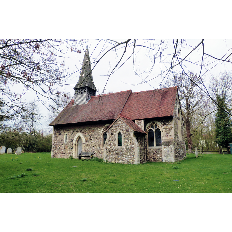
Image copyright © Derek Voller, 2019
CC-BY-SA-2.5
Results: 2 records
view of church exterior - southeast view
Scene Description: Source caption: "All Saints church, Ulting, Essex"
Copyright Statement: Image copyright © Derek Voller, 2019
Image Source: digital photograph 21 March 2019 by Derek Voller [https://www.geograph.org.uk/photo/6095187] [accessed 2 June 2024]
Copyright Instructions: CC-BY-SA-2.5
design element - architectural - arcade - blind - pointed arches - 8
![arches or panels [cf. Font notes]](/static-50478a99ec6f36a15d6234548c59f63da52304e5/others/image_not_available.jpg)
Scene Description: arches or panels [cf. Font notes]
![arches or panels [cf. Font notes]](/static-50478a99ec6f36a15d6234548c59f63da52304e5/bsi-testing-site/others/image_not_available.jpg)
INFORMATION
Font ID: 11739ULT
Object Type: Baptismal Font1
Font Century and Period/Style: 13th century (early?) [basin only] [composite font], Transitional / Early English [altered]
Church / Chapel Name: Parish Church of All Saints
Font Location in Church: Inside the church
Church Patron Saint(s): All Saints
Church Notes: church 1150; restored 1870s
Church Address: Church Rd, Ulting, Maldon CM9 6QU, United Kingdom -- Tel.: +44 1245 380958
Site Location: Essex, East, England, United Kingdom
Directions to Site: Located off the FP33, 5 km NW of Maldon, 6-7 km NNE of Chelmsford town centre
Ecclesiastic Region: Diocese of Chelmsford
Historical Region: Hundred of Witham [in Domesday]
Additional Comments: altered font: earlier base replaced
Font Notes:
Click to view
There is an entry for Ulting [variant spelling] in the Domesday survey [https://opendomesday.org/place/TL8008/ulting/] [accessed 2 June 2024]; it mentions neither priest nor church in it. Noted in the Royal Commission on Historical Monuments (Essex, 1916-1923): "Font: octagonal bowl of Purbeck marble with shallow pointed panels, early 13th-century." Listed in Leach (1975) as a font made of Purbeck marble; "bowl with one panels on each face; no subsidiary shafts". In Pevsner (1976): "Font. Of Purbeck marble; not square but octagonal with only one of the usual blank arches per side. The angles of the octagon are chamfered." Bettley & Pevsner (2007) suggest dates for the basin, "early C13" and for the base, "C19". The entry for this church in Historic England [List Entry Number: 1111002] notes: "Parish church. C13 nave and chancel, chancel with earlier core, restored and extended 1873 [...] Octagonal font, probably early C13 Purbeck marble bowl, with two-centre arched sunk panels, chamfered angles and rim, supported on central and angle columns, on later plain octagonal base."
COORDINATES
UTM: 31U 334886 5735785
Latitude & Longitude (Decimal): 51.7486, 0.608069
Latitude & Longitude (DMS): 51° 44′ 54.96″ N, 0° 36′ 29.05″ E
MEDIUM AND MEASUREMENTS
Material: stone, limestone (Purbeck marble)
Font Shape: octagonal, mounted
Basin Interior Shape: round
Basin Exterior Shape: octagonal
REFERENCES
- Bettley, James, Essex, New Haven and London: Yale University Press, 2007, p. 796
- Great Britain. Royal Commission on Historical Monuments, An Inventory of the historical monuments in Essex, London: H.M. Stationary Office, 1916-1923, vol. 2: 237
- Leach, Rosemary, A Investigation into the use of Purbeck Marble in Medieval England, Hartlepool: E.W. Harrisons & Sons, 1975, p. 78
- Pevsner, Nikolaus, Essex, Harmondsworth: Penguin, 1976, p. 397