Radway / Radwei / Radweia / Rodewei
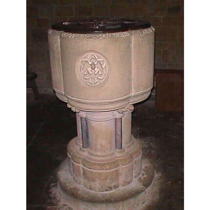
Image copyright © John Wilkes, 2006
Image and permission received (e-mail of 17 March 2006)
Results: 3 records
view of font and cover
Scene Description: the modern font
Copyright Statement: Image copyright © John Wilkes, 2006
Image Source: digital photograph by John Wilkes [www.allthecotswolds.com]
Copyright Instructions: Image and permission received (e-mail of 17 March 2006)
view of church exterior
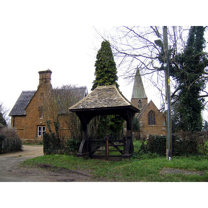
Scene Description: the new church
Copyright Statement: Image copyright © Jonathan Billinger, 2007
Image Source: digital photograph taken 1 February 2007 by Jonathan Billinger [www.geograph.org.uk/photo/343345] [accessed 13 January 2015]
Copyright Instructions: CC-BY-SA-2.0
view of church exterior - churchyard, cemetery
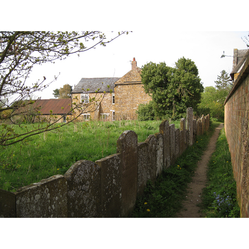
Scene Description: Source caption: "Footpath by the old churchyard"
Copyright Statement: Image copyright © Robin Stott, 2010
Image Source: digital photograph taken 24 April 2010 by Robin Stott [www.geograph.org.uk/photo/1833597] [accessed 13 January 2015]
Copyright Instructions: CC-BY-SA-2.0
INFORMATION
Font ID: 11585RAD
Object Type: Baptismal Font1
Font Century and Period/Style: 11th - 12th century, Norman
Church / Chapel Name: Old Parish Church of St. Peter [in ruins]
Church Patron Saint(s): St. Peter
Church Address: Tysoe Road, Radway, Warwickshire CV35 0UE, UK
Site Location: Warwickshire, West Midlands, England, United Kingdom
Directions to Site: Located between the A422 and the B4086, just E of the Edgehill battle grounds, about 12 km NW of Banbury
Ecclesiastic Region: Diocese of Coventry
Historical Region: Hundred of Hunesberi [in Domesday] -- Hundred of Kington
Additional Comments: disappeared font? (the font from the medieval church probably built after 1086)
Font Notes:
Click to view
There are three entries for Radway [variant spelling] in the Domesday survey [http://domesdaymap.co.uk/place/SP3648/radway/] [accessed 13 January 2015], neither of which mention cleric or church in it. The Victoria County History (Warwick, vol. 5, 1949) notes: "The church of Radway was appropriated to the Abbey of Stoneleigh before 1291 [...] rebuilt on a new site in 1866"; no font mentioned. English Heritage [Listing NGR: SP3681648080] (1967) reports a "Stone font with lobed bowl and composite stem" in this church. The Warwickshire County Council site [http://timetrail.warwickshire.gov.uk/detail.aspx?monuid=WA694] [accessed 13 January 2015] notes: "The site of the Medieval Church of St Peter which was the parish church in Radway. It was rebuilt on a different site in 1886. The remains of the Medieval Church are still visible, as are some grave stones and a memorial. The site is located to the south of the present Church." The present baptismal font in the new church consists of a quatrefoi-shaped basin of vertical sides raised on a stem formed by a cluster of columns and a moulded lower base; the front side of the basin has a star-shaped symbol on it; there are curlicues on the underbowl; the upper rim side has a running inscription; flat wooden cover of the same shape as the basin. The font appears late-Victorian, of the late-19th century, the date of the new church. [NB: we have no information on the font of the original medieval church now in ruins; a Norman piscina was found among the ruins, suggesting a church founded soon after 1086].
COORDINATES
UTM: 30U 605138 5776610
Latitude & Longitude (Decimal): 52.13, -1.464
Latitude & Longitude (DMS): 52° 7′ 48″ N, 1° 27′ 50.4″ W
INSCRIPTION
Inscription Language: English
Inscription Location: around the upper rim edge
Inscription Text: "[...] BAPTIZED[...]"
Inscription Notes: full text not available
Inscription Source: cf. Image Area
LID INFORMATION
Date: 19th century?
Material: wood
Apparatus: no
Notes: [cf. FontNotes]
REFERENCES
- Victoria County History [online], University of London, 1993-. URL: https://www.british-history.ac.uk.