Pitcombe / Pidecome
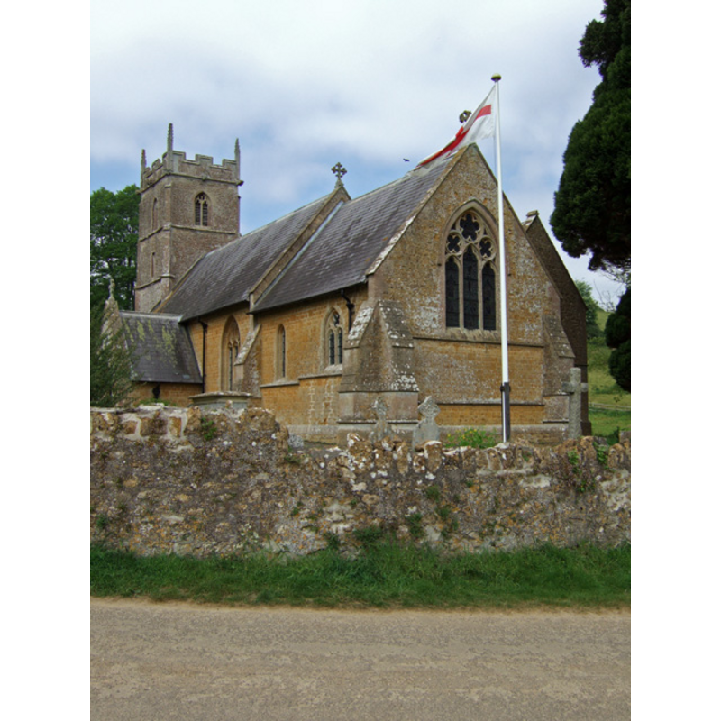
Image copyright © Mike Searle, 2007
CC-BY-SA-3.0
Results: 1 records
view of church exterior - southeast view
Scene Description: Source caption: "The church of St. Leonard, was with the exception of the tower rebuilt in 1857-8 to designs by G. E. Street."
Copyright Statement: Image copyright © Mike Searle, 2007
Image Source: digital photograph taken 5 May 2007 by Mike Searle [www.geograph.org.uk/photo/424253] [accessed 26 August 2013]
Copyright Instructions: CC-BY-SA-3.0
INFORMATION
Font ID: 11484PIT
Object Type: Baptismal Font1?
Font Century and Period/Style: 12th century, Norman
Workshop/Group/Artisan: lead font?
Church / Chapel Name: Parish Church of St. Leonard
Font Location in Church: Inside the church
Church Patron Saint(s): St. Leonard
Church Address: Church Lane / Mill Lane, Pitcombe, Somerset BA10 0PE, UK -- Tel.: +44 1963 351492
Site Location: Somerset, South West, England, United Kingdom
Directions to Site: Located off the A359, 2 km SSW of Bruton, about 8 km NW of Wincanton
Ecclesiastic Region: Diocese of Bath & Wells
Historical Region: Hundred of Bruton
Font Notes:
Click to view
There is an entry for Pitcombe [variant spelling] in the Domesday survey [http://opendomesday.org/place/ST6732/pitcombe/] [accessed 12 April 2018], but it mentions neither cleric nor church in it. Phelps (1836) reports "an ancient font" in this church. Paley (1844), Cox (1875) and Lethaby (1893) list a "leaden font" here. Wade & Wade (1929) write: "The church, with the exception of the tower, has been rebuilt, and contains nothing of interest, except an ancient font." The entry for this parish in the Victoria County History (Somerset, vol. 7, 1999) notes: "Pitcombe was at first probably a dependent chapel of the minster, and certainly of the later priory, at Bruton. The early 12th-century font may be the earliest evidence for a church and may signify that partial independence had been achieved by then." The entry for this church in the National Monuments Record [Listing NGR: ST6727332719] notes: "Norman tub font set on later base". Not mentioned in Pevsner (1958).
COORDINATES
UTM: 30U 537214 5660264
Latitude & Longitude (Decimal): 51.092669, -2.468595
Latitude & Longitude (DMS): 51° 5′ 33.61″ N, 2° 28′ 6.94″ W
MEDIUM AND MEASUREMENTS
Material: stone
Font Shape: tub-shaped
Basin Interior Shape: round
Basin Exterior Shape: round
REFERENCES
- Victoria County History [online], University of London, 1993-. URL: https://www.british-history.ac.uk.
- Cox, John Charles, 1875-1877
- Lethaby, William Richard, Leadwork, old and ornamental, and for the most part English [...] with illustrations, London; New York: Macmillan & co., 1893, p. 63
- Paley, Frederick Apthorp, Illustrations of Baptismal Fonts, London, UK: John van Voorst, 1844, p. 24
- Phelps, William (Revd.), The History and Antiquities of Somersetshire; being a general and parochial survey [...] [vol. 1], London: Printed for the author , by J. B. Nichols and Son, 1836, vol. 1: 260
- Wade, G.H., Somerset, London: Methurn & Co., 1929, [www.gutenberg.org/files/12287/12287-h/12287-h.htm] [accessed 4 April 2008]