Dorchester nr. Weymouth No. 2 / Dore Cestre / Dorecestre
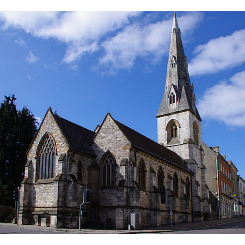
Image copyright © Chris Talbot, 2012
CC-BY-SA-2.0
Results: 2 records
view of church exterior - northeast view
Scene Description: Source caption: "Dorchester - All Saints Church [...] has has also been known as 'Alhalens' or 'All Hallows'"
Copyright Statement: Image copyright © Chris Talbot, 2012
Image Source: edted detail of a digital photograph taken 1 April 2012 by Chris Talbot [www.geograph.org.uk/photo/3006564] [accessed 2 Fabruary 2020]
Copyright Instructions: CC-BY-SA-2.0
design element - architectural - arcade - blind - round arches
![[cf. Font notes]](/static-50478a99ec6f36a15d6234548c59f63da52304e5/others/image_not_available.jpg)
Scene Description: [cf. Font notes]
![[cf. Font notes]](/static-50478a99ec6f36a15d6234548c59f63da52304e5/bsi-testing-site/others/image_not_available.jpg)
INFORMATION
Font ID: 11399DOR
Object Type: Baptismal Font1
Font Century and Period/Style: Medieval
Church / Chapel Name: Parish Church of All Saints [aka Alhalens' / All Hallows] [redundant 1970; became archaeological store for the Dorset County Museum]
Font Location in Church: Reported inside the tower ca. 1970
Church Patron Saint(s): All Saints
Church Address: 32 High E St, Dorchester DT1 1HF, UK
Site Location: Dorset, South West, England, United Kingdom
Directions to Site: Located off the B3150 [aka Bridport Rd / London Rd], N and W of the A35, 13 km N of Weymouth
Ecclesiastic Region: Diocese of Salisbury
Historical Region: Hundred of Dorchester
Additional Comments: disused font? / disappeared font? (the one from the Domesday-time church here)
Font Notes:
Click to view
There are three entries for this Dorchester [variant spelling] in the Domesday survey [http://domesdaymap.co.uk/place/SY6890/dorchester/] [accessed 2 November 2014], reporting two churches and church lands here. During his visit to this church in October 1825, Glynne (1923) noted: "The font is of an early period, and is a large square moulded (one) with semi-circular arches, and upon a plain pedestal." In a later visit in 1852. Glynne (ibid.) added: "All Saints church was wholly rebuilt about 1841. Not a vestige of the old church remains." The entry for this church in An Inventory of the Historical Monuments in Dorset (vol. 2, Souuth east, 1970) notes: "The old church on the site was destroyed by fire in 1613. Its replacement was itself demolished and replaced in the mid 19th century by the present church in the early 14th-century Gothic style from the designs of Benjamin Ferrey; the foundation stone was laid in 1843 [...] Fonts: In N.W. tower, square bowl, each face with arcading of round-headed sunk panels, 12th-century, disused. In nave, of freestone, octagonal, with ogee-headed panels on each face framing trefoil-headed sinkings, on each angle a large blank shield, probably 1843. The modern font-cover incorporates a globe and dove said to be from the former sounding-board of the pulpit."
COORDINATES
UTM: 30U 539852 5618329
Latitude & Longitude (Decimal): 50.7154, -2.4355
Latitude & Longitude (DMS): 50° 42′ 55.44″ N, 2° 26′ 7.8″ W
MEDIUM AND MEASUREMENTS
Material: stone
Font Shape: square, mounted
Basin Exterior Shape: square
REFERENCES
- Glynne, Stephen Richard, "Notes on some Dorset churches", 44, 86-104, Proceedings of the Dorset Natural History and Antiquarian Field Club, 1923