Almer / West Almer
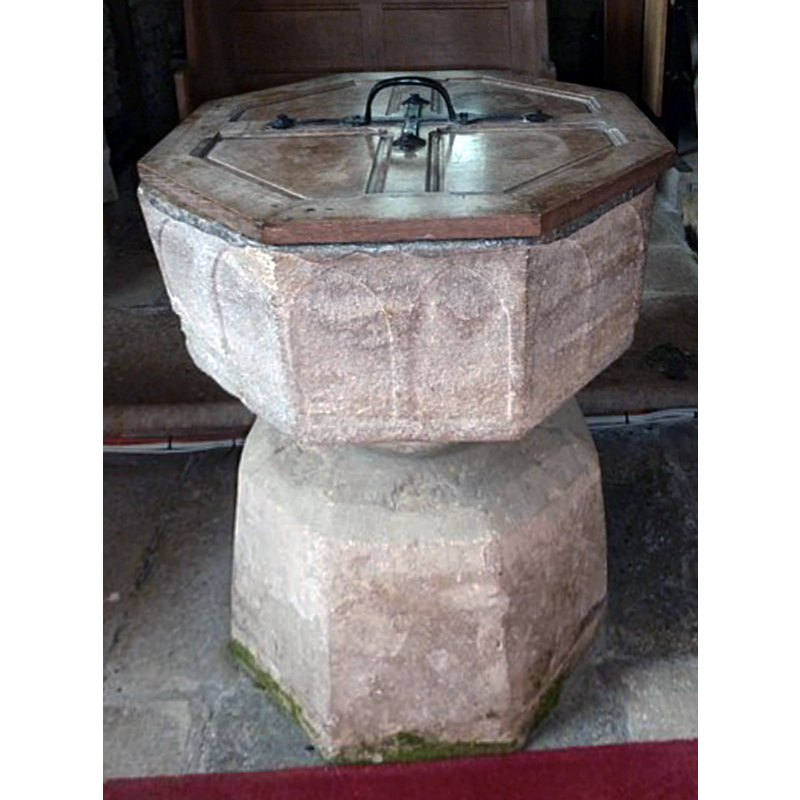
Image copyright © Basher Eyre, 2012
CC-BY-SA-2.5
Results: 5 records
view of font and cover - east side
Scene Description: Source caption: "St Mary, Almer: font" -- the lead lining is partially showing under the cover; the 'base' has been identified in some sources as a re-used font basin [cf. FontNotes]
Copyright Statement: Image copyright © Basher Eyre, 2012
Image Source: edited detail of a digital photograph 3 October 2012 by Basher Eyre [https://www.geograph.org.uk/photo/3161646] [accessed 20 February 2023]
Copyright Instructions: CC-BY-SA-2.5
design element - architectural - arcade - blind - pointed arches - 16
Scene Description: a pair on each of the eight sides of the basin
Copyright Statement: Image copyright © Basher Eyre, 2012
Image Source: edited detail of a digital photograph 3 October 2012 by Basher Eyre [https://www.geograph.org.uk/photo/3161646] [accessed 20 February 2023]
Copyright Instructions: CC-BY-SA-2.5
view of church exterior - southeast view
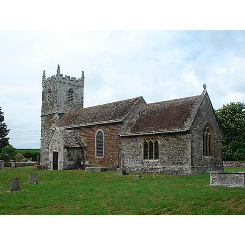
Scene Description: Source caption: "St Mary's Church Almer"
Copyright Statement: Image copyright © Ray Beer, 2007
Image Source: digital photograph 8 May 2007 by Ray Beer [https://www.geograph.org.uk/photo/426721] [accessed 20 February 2023]
Copyright Instructions: CC-BY-SA-2.5
view of church interior - looking east
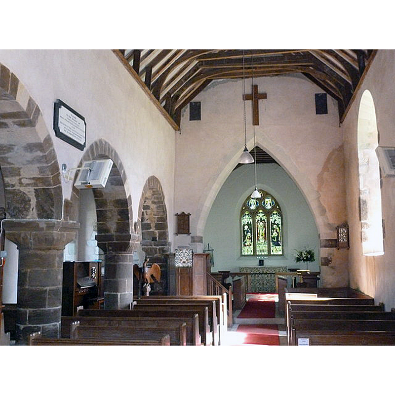
Scene Description: Source caption: "Inside St Mary, Almer"
Copyright Statement: Image copyright © Basher Eyre, 2012
Image Source: digital photograph 8 September 2012 by Basher Eyre [https://www.geograph.org.uk/photo/3161622] [accessed 20 February 2023]
Copyright Instructions: CC-BY-SA-2.5
view of church interior - looking west
![Source caption: "Inside St Mary, Almer" -- showing the font and cover at the far [west] end](/static-50478a99ec6f36a15d6234548c59f63da52304e5/compressed/1230220013_compressed.png)
Scene Description: Source caption: "Inside St Mary, Almer" -- showing the font and cover at the far [west] end
Copyright Statement: Image copyright © Basher Eyre, 2012
Image Source: digital photograph 8 September 2012 by Basher Eyre [https://www.geograph.org.uk/photo/3161623] [accessed 20 February 2023]
Copyright Instructions: CC-BY-SA-2.5
INFORMATION
Font ID: 11281ALM
Object Type: Baptismal Font1
Font Century and Period/Style: 13th century, Early English
Cognate Fonts: A group of Dorset fonts noted in Long (1923) including: "West Almer, Canford Magna, Cranborne, East Morden, Hazelbury Bryan, Shapwick, Whitcombe, Wimborne Minster and Wootton Glanville."
Church / Chapel Name: Parish Church of St. Mary
Font Location in Church: Inside the church, at the W end
Church Patron Saint(s): St. Mary the Virgin
Church Address: 9EP, Almer, Blandford Forum DT11 9EN, United Kingdom
Site Location: Dorset, South West, England, United Kingdom
Directions to Site: Located off the A31, 7-8 km SSE of Blandofrd Forum, 12 km W of Wimborne Minster
Ecclesiastic Region: Diocese of Salisbury
Additional Comments: recycled font: the base of the font is another font
Font Notes:
Click to view
Noted in the 3rd ed. of Hutchins (1973 c1861-1874): "The bowl of the font is octagonal, with two shallow pointed arches on each face. It seems originally to have stood upon six small pillars surrounding the massive central stem." Noted in Long (1923) as a good example of "a considerable number of Early English fonts in this county [...] mostly of Purbeck marble, a fact which leads one to suppose that the majority were constructed in or near the Isle of Purbeck, and exported in considerable quantities to other parts of Dorset, and even much further afield. The type consists of an octagonal bowl, with shallow pointed arcading on the sides. The bowl is usually mounted on a thick central, and four or eight smaller detached angle shafts, standing on a low plain base." In Newman & Pevsner (1972): "Font. C13, Purbeck marble, octagonal, with two flat pointed arches each side [...] The base of the font is another, reversed, font." The entry for this church in Historic England [Listing NGR: SY9132098931] notes: "Parish church. C12 nave and north arcade, C14 rebuilding of the north aisle, west tower of C15, south wall of nave and south porch C18 (1720), chancel rebuilt late C19, restoration of 1908 [...] the Purbeck font (c1400) has an octagonal bowl with coupled arches to each face, supported on a narrow column, which rests on a C13 inverted bowl (itself re-cut)." Noted in Leach (1975) as a font made of Purbeck marble, Polygonal I Type (Octagonal): no details [source given: E.T. Long].
COORDINATES
UTM: 30U 561703 5626827
Latitude & Longitude (Decimal): 50.7899, -2.1246
Latitude & Longitude (DMS): 50° 47′ 23.64″ N, 2° 7′ 28.56″ W
MEDIUM AND MEASUREMENTS
Material: stone, limestone (Purbeck marble)
Font Shape: octagonal, mounted
Basin Interior Shape: round
Basin Exterior Shape: octagonal
Drainage Notes: lead lined
LID INFORMATION
Material: wood
Apparatus: no
Notes: octagonal, plain and flat; metal handle; appears modern
REFERENCES
- Hutchins, John, The History and Antiquities of the County of Dorset, Wakefield: E.P. Pub. Ltd., 1973, vol. 3: 496
- Leach, Rosemary, A Investigation into the use of Purbeck Marble in Medieval England, Hartlepool: E.W. Harrisons & Sons, 1975, p. 75
- Long, E.T., "Dorset church fonts", 44, Proceedings of the Dorset Natural History and Antiquarian Field Club, 1923, pp. 62-76; p. 69, 76
- Pevsner, Nikolaus, Dorset, Harmondsworth: Penguin, 1972, p. 75