Mexborough / Mechesburg
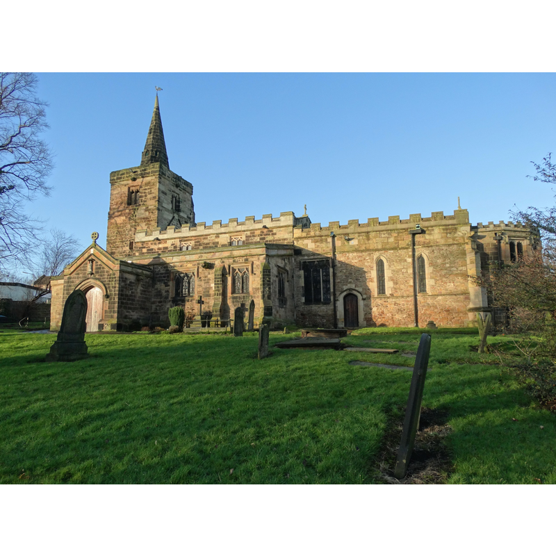
Image copyright © Neal Theasby, 2016
CC-BY-SA-2.0
Results: 3 records
view of church exterior - southeast view
Scene Description: Source caption: "Parish Church of St John the Baptist, Mexborough. Mexborough parish church is very ancient in origin. Documents show that a church was on this site shortly after the Norman Conquest in 1066. In 1350-1400 the church consisted of a tower and spire, a nave and a square-headed chancel. When the refurbishment in 1890 started, it was evident that the church had gone through three stages of restoration."
Copyright Statement: Image copyright © Neal Theasby, 2016
Image Source: digital photograph taken 22 January 2016 by Neil Theasby [www.geograph.org.uk/photo/4801532] [accessed 16 November 2018]
Copyright Instructions: CC-BY-SA-2.0
view of church interior - nave - looking west
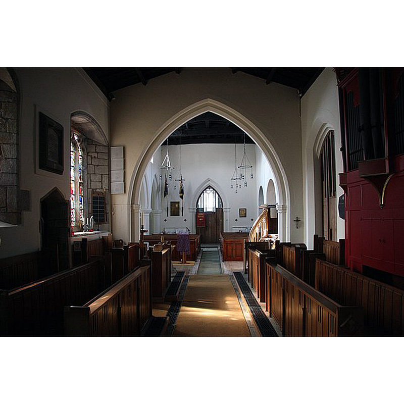
Copyright Statement: Image copyright © Richard Croft, 2009
Image Source: digital photograph taken 20 March 2009 by Richard Croft [www.geograph.org.uk/photo/1215744] [accessed 16 November 2018]
Copyright Instructions: CC-BY-SA-2.0
view of church interior - nave - looking east
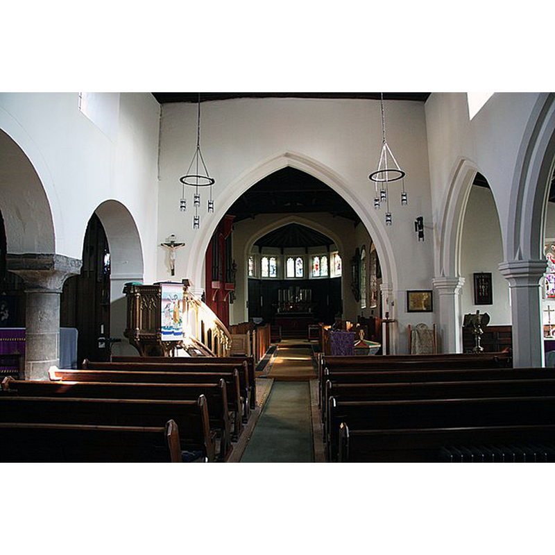
Scene Description: Source caption: "St.John the Baptist's nave. Plain late 12th century north arcade and 15th century south arcade in St.John the Baptist's church"
Copyright Statement: Image copyright © Richard Croft, 2009
Image Source: digital photograph taken 20 March 2009 by Richard Croft [www.geograph.org.uk/photo/1215721] [accessed 16 November 2018]
Copyright Instructions: CC-BY-SA-2.0
INFORMATION
Font ID: 11229MEX
Object Type: Baptismal Font1
Font Century and Period/Style: 14th century, Medieval
Church / Chapel Name: Parish Church of St. John the Baptist
Font Location in Church: [cf. FontNotes]
Church Patron Saint(s): St. John the Baptist
Church Address: Church St, Mexborough S64 0ER, United Kingdom -- Tel.: +44 1709 582321
Site Location: South Yorkshire, Yorkshire and the Humber, England, United Kingdom
Directions to Site: Located off (N) the A6023, 10 km NE of Rotherham
Ecclesiastic Region: Diocese of Sheffield
Historical Region: Hundred of Strafforth -- formerly WRYrks
Additional Comments: buried font - unused font (the present font) -- disappeared font? (the one from the original (10th-11thC?) church here)
Font Notes:
Click to view
There is an entry for Mexborough [variant spelling] in the Domesday survey [http://opendomesday.org/place/SE4700/mexborough/] [accessed 16 November 2018] but it mentions neither cleric nor church in it. Hunter (1828-1831) writes: "The large octagonal font is doubtless […] a relic of the original church". In Moule (1837). Noted in Glynne's 16 April 1853 visit to this church (in Butler, 2007): "The font has an octagonal bowl and some rope moulding." Armitage (1905) writes: "I was informed that the old font was buried inside the tower; I do not know what it had been doing to deserve this." Noted in Mee (1941) as a medieval relic "recovered after being buried". The entry for this church in Historic England [Listing NGR: SK4797299741] notes: "Church. C12 core, otherwise C13, C14 and C15; aisle rebuilt and apse added 1891. [...] Medieval, octagonal font. Remains of C10-Cll cross in south aisle." In Harman & Pevsner (2017): "Dumpty octagon. C14?" The CRSBI (2018) notes, citing Clay (C. T. Clay, 'York Minster Fasti I', Yorkshire Archaeological Society Record Series (123), Leeds, 1958, 57-8.): "the church was founded by the Saxon family of Ailric, and post Conquest was in two parts, one given by Montbegon to the house of Bretton (Monk Bretton), and the other to St Nicholas at Pontefact by Swein, which subsequently came to Nostell priory. Later in the 13th century both halves were transferred to the archdeaconry of York. The two parts of the church were disputed between the archdeacon of York and Monk Bretton priory in 1262 and both confirmed to the archdeacon (Clay 1958, 57-8)." The CRSBI entry (ibid.) also notes: "Font, octagonal bowl and some rope moulding", but gives no date for the font.
COORDINATES
UTM: 30U 614214 5928409
Latitude & Longitude (Decimal): 53.49223, -1.2784
Latitude & Longitude (DMS): 53° 29′ 32.03″ N, 1° 16′ 42.24″ W
MEDIUM AND MEASUREMENTS
Material: stone
Font Shape: octagonal
Basin Exterior Shape: octagonal
REFERENCES
- Armitage, Ella S., A key to English antiquities with special reference to the Sheffield and Rotherham disctrict, London: J.M. Dent & Co., 1905, p. 262
- Glynne, Stephen Richard, The Yorkshire notes of Sir Stephen Glynne (1825-1874), Woodbridge: The Boydell Press; Yorkshire Archaeological Society, 2007, p. 294
- Harman, Ruth, Yorkshire West Riding: Sheffield and the South, New Haven; London: Yale University Press, 2017, p. 403
- Hunter, Joseph, South Yorkshire, Wakefield: EP Publishing for Sheffield City Libraries, 1974 c1828-1931, vol. 1: 394
- Mee, Arthur, The King's England, Yorkshire, West Riding, London: Hodder & Stoughton, 1941, p. 257
- Moule, Thomas, The English counties delineated; or, A topographical description of England [...], London: George Virtue, 1837 [vol. 2], vol. 2: 491