Long Preston / Prestune
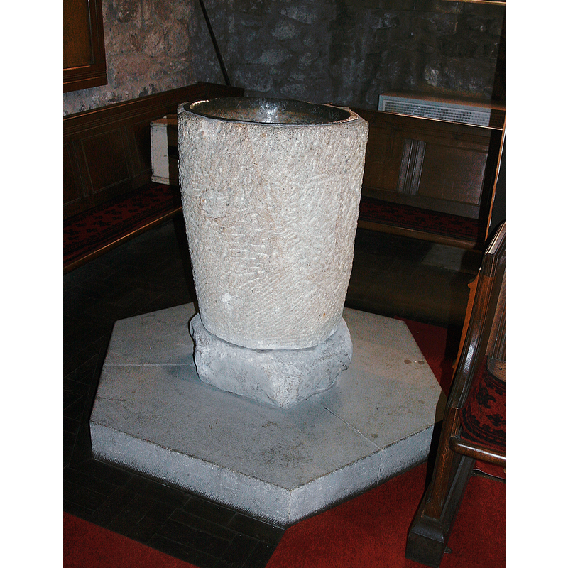
Image copyright © Jim Woodward-Nutt, 2011
CC-BY-SA-3.0
Results: 4 records
view of font
Scene Description: Source caption: "The Font at St Mary's Long Preston. The carved stone font is late Saxon or early Norman." [NB: Pevsner's comment on its date "probably Norman, but whether early or Later, or indeed pre-Norman, it seems impossible to say" is apprpriate; one other source [cf. FontNotes] states that it is made of sandstone and has a zig-zag.moulding on it [where?]; there is a patched hole noticesble about 2/3 up the left side; was the font used as a garden planter? a water-trough?]
Copyright Statement: Image copyright © Jim Woodward-Nutt, 2011
Image Source: digital photograph taken 30 April 2011 by Jim Woodward-Nutt [www.geograph.org.uk/photo/2407006] [accessed 23 September 2020]
Copyright Instructions: CC-BY-SA-3.0
view of church exterior - southeast view
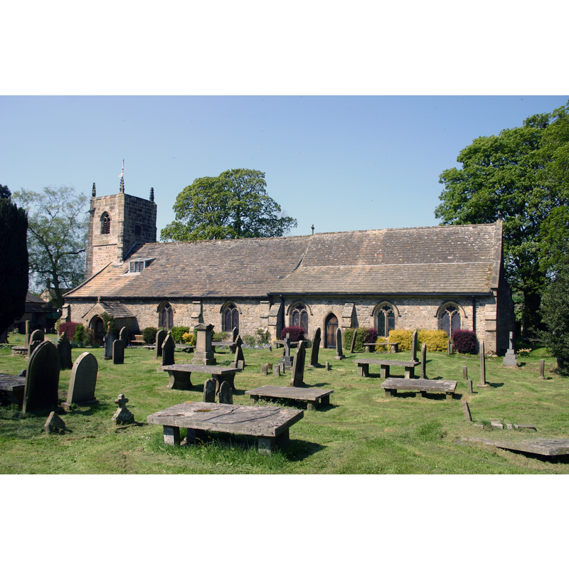
Copyright Statement: Image copyright © Jim Woodward-Nutt, 2011
Image Source: digital photograph taken 30 April 2011 by Jim Woodward-Nutt [www.geograph.org.uk/photo/2406948] [accessed 23 September 2020]
Copyright Instructions: CC-BY-SA-3.0
view of church interior - looking east
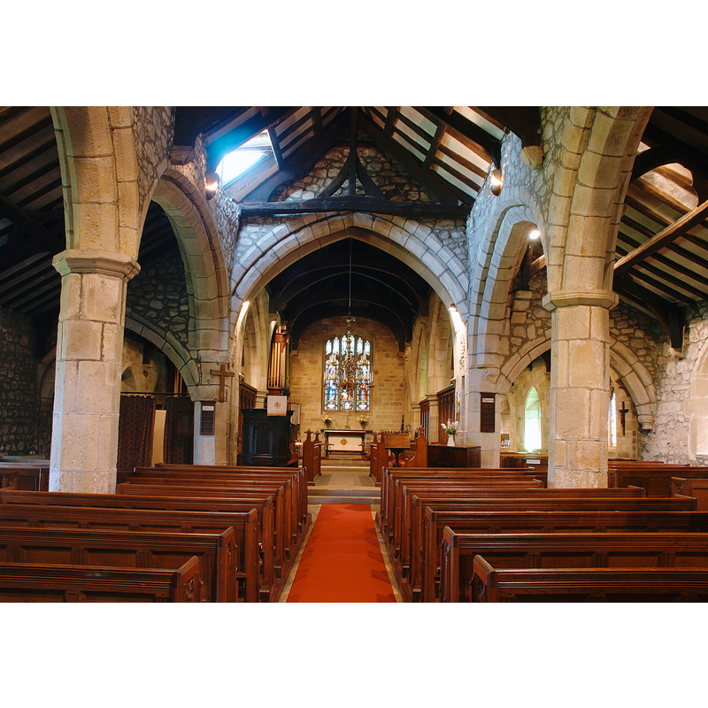
Scene Description: Source caption: "The Nave and Chancel at St Mary's Church. The present church dates from the late 14th or early 15th century. Note the leaning columns on the right hand side of the nave!"
Copyright Statement: Image copyright © Jim Woodward-Nutt, 2011
Image Source: digital photograph taken 30 April 2011 by Jim Woodward-Nutt [www.geograph.org.uk/photo/2406979] [accessed 23 September 2020]
Copyright Instructions: CC-BY-SA-3.0
view of canopy
![Source caption: "The Font Canopy at St Mary's Church [...] bears the date 1726, and the initials of the churchwardens at the time."](/static-50478a99ec6f36a15d6234548c59f63da52304e5/compressed/1200923014_compressed.png)
Scene Description: Source caption: "The Font Canopy at St Mary's Church [...] bears the date 1726, and the initials of the churchwardens at the time."
Copyright Statement: Image copyright © Jim Woodward-Nutt, 2011
Image Source: digital photograph taken 30 April 2011 by Jim Woodward-Nutt [www.geograph.org.uk/photo/2406966] [accessed 23 September 2020]
Copyright Instructions: CC-BY-SA-3.0
INFORMATION
Font ID: 11186PRE
Object Type: Baptismal Font1
Font Century and Period/Style: 11th - 12th century, Norman
Church / Chapel Name: Parish Church of St. Mary
Font Location in Church: Inside the church, at the W end
Church Patron Saint(s): St. Mary the Virgin
Church Notes: a church in Prestune [Long Preston] is mentioned in the Domesday survey
Church Address: Church St, Long Preston, Skipton BD23 4NJ, UK -- Tel.: +44 1729 851511
Site Location: West Yorkshire, Yorkshire and the Humber, England, United Kingdom
Directions to Site: Located off (E) the A65, 7-8 km S of Settle
Ecclesiastic Region: Diocese of Leeds
Historical Region: Hundred of Craven
Additional Comments: altered font: in the mid-19th century the font was encased in wood; it would not have been its original state, being Norman (?); the casing was later removed
Font Notes:
Click to view
There is a multiple entry that includes [Long] Preston [variant spelling] in the Domesday survey [https://opendomesday.org/place/SD8358/long-preston/] [accessed 23 September 2020]; it mentions a church in it.. A baptismal font here is noted in Glynne's August 1846 (?) visit to this church (in Butler, 2007): "The font is cased in wood and has a high Jacobean wood cover, as at Skipton" [NB: Butler's (ibid.) later annotation of Glynne reads: "The font is no longer cased in wood; the cover carries the date 1726 though the style is seventeenth-century." Noted in Morris (1932): "Very rude hexagonal font, with cover dated 1726." Mee (1941) has: "The crude six-sided Norman font has a cover of 1726 like a tower." [NB: unlikely Norman dating for the font itself -- did Mee transfer the shape of the cover or of the base to the font?]. Pevsner (1986 c1967) writes: "Font. Circular, with very tall, tapering bowl. The date probably Norman, but whether early or Later, or indeed pre-Norman, it seems impossible to say. Font cover. An interesting piece, in so far as it is Jacobean in character yet dated as late as 1726. Hexagonal, two tiers, and crocketed spire. The upper tier with simple openwork foliage." The entry for this church in Historic England [Listing NGR: SD8371758092] notes: "Parish church. Late C14/early C15 with C19 and C20 alterations. [...] Romanesque sandstone font with zig-zag moulding; 1726 oak canopy."
COORDINATES
UTM: 30U 549139 5985907
Latitude & Longitude (Decimal): 54.0191, -2.25
Latitude & Longitude (DMS): 54° 1′ 8.76″ N, 2° 15′ 0″ W
MEDIUM AND MEASUREMENTS
Material: stone
Font Shape: round, mounted
Basin Interior Shape: round
Basin Exterior Shape: round
Drainage Notes: lead-lined
LID INFORMATION
Date: 1726
Material: wood, oak
Notes: [cf. FontNotes]
REFERENCES
- Glynne, Stephen Richard, The Yorkshire notes of Sir Stephen Glynne (1825-1874), Woodbridge: The Boydell Press; Yorkshire Archaeological Society, 2007, p. 281
- Mee, Arthur, The King's England, Yorkshire, West Riding, London: Hodder & Stoughton, 1941, p. 248
- Morris, Joseph Ernest, The West Riding of Yorkshire, London: Methuen & Co., 1932, p. 344
- Pevsner, Nikolaus, Yorkshire: the West Riding, Harmondsworth: Penguin Books, 1986 c1967, p. 357