Rokeby / Rochebi / Rookeby
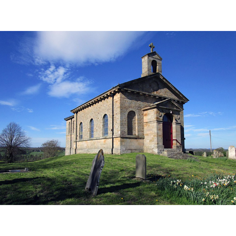
Image copyright © Jonathan Thacker, 2018
CC-BY-SA-2.0
Results: 1 records
view of church exterior
Scene Description: If the church were canonically oriented -which it is not- this would be the southwest view of the late-18thC church that replaced a medieval one
Copyright Statement: Image copyright © Jonathan Thacker, 2018
Image Source: digital photograph taken 4 May 2018 by Jonathan Thacker [www.geograph.org.uk/photo/5768016] [accessed 12 November 2019]
Copyright Instructions: CC-BY-SA-2.0
INFORMATION
Font ID: 11082ROK
Object Type: Baptismal Font1?
Font Date: ca. 1200?
Font Century and Period/Style: 12th - 13th century, Transitional
Church / Chapel Name: Parish Church of St. Michael [in ruins / Scheduled Monument]
Font Location in Church: [cf. FontNotes]
Church Patron Saint(s): St. Michael
Church Address: [the ruins of the medieval church are 50m north west of Dairy Bridge, Rokeby Park]
Site Location: Durham, North East, England, United Kingdom
Directions to Site: [the ruins of the medieval church are located off Mortham Ln, 50 m NW of Dairy Bridge, Rokeby Park, S of Barnard Castle]
Historical Region: Hundred of Land of Count Alan -- formerly NRYrks
Additional Comments: disappeared font? (the one from the ca.1200 church here)
Font Notes:
Click to view
There is an entry for Rokeby (Hall) [variant spelling] in the Domesday survey [https://opendomesday.org/place/NZ0814/rokeby-hall/] [accessed 4 February 2020] but it mentions neither cleric nor church in it. There is a reference to Rokeby and a 'font' related to the church of St Mary there [cf. infra]. The entry for this parish in the Victoria County History (York North Riding, vol. 1, 1914) notes: "The advowson of Rokeby Church belonged to Brian Fitz Alan in 1204 [...] The church of ST. MARY THE VIRGIN is a small and plain structure of Renaissance design, built by Sir Thomas Robinson in 1740, in place of the older church, which stood to the north-east of Rokeby Hall, near the Tees; nothing but a few marks in the turf remain to show its site, and a few gravestones only are left in position. [...] The font is in modern Gothic style." The entry for the remains of St Michael's Church in Rokeby Park [List Entry Number: 1016875 / 24 Sept. 1999] notes: "The church has an association with Rokeby Hall which can be traced back to the 13th century, and burials indicate its existence in the 12th century. The extent of the churchyard is well preserved and deposits within the churchyard are undisturbed and will be well preserved beneath the present ground surface. The monument includes the earthwork and buried remains of St Michael's Church, which is situated 50m north west of Dairy Bridge and within the north east corner of the grounds of Rokeby Park. The monument includes the church, a socket stone for a cross and an associated graveyard. The church survives as an earthwork up to 0.5m high"; no font mentioned. The entry for the modern church in Historic England [Listing NGR: NZ0725713808] notes; "Parish Church. Consecrated 1778 [...] Free-standing font by Mason: mahogany, fluted bowl on slender tripod base." Pevsner (1985) writes: "Font. A delighful, Adamish piece of mahogany. Small flutred bowl on a very slim baluster and three yet slimmer tripod feet." [NB: we have no information on the font of the medieval church here]
COORDINATES
UTM: 30U 572827 6042199
REFERENCES
- Victoria County History [online], University of London, 1993-. URL: https://www.british-history.ac.uk.
- Pevsner, Nikolaus, Yorkshire: the North Riding, Harmondsworth: Penguin Books, 1985 c1966, p. 310
- Whitaker, Thomas Dunham, An history of Richmondshire, in the North Riding of the County of York [...], with illustrations by J.M.W. Turner, London: [s.n.], 1823, vol. 1: 154