Brougham No. 1 / Brovacum
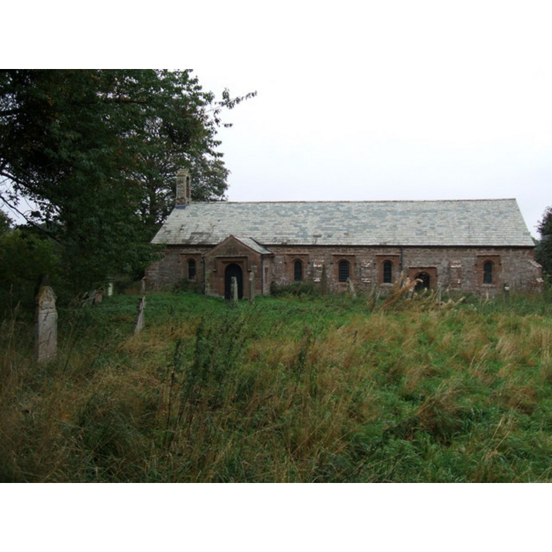
Image copyright © David Brown, 2009
CC-BY-SA-3.0
Results: 5 records
view of church exterior - south view
Copyright Statement: Image copyright © David Brown, 2009
Image Source: digital photograph taken 14 October 2009 by David Brown [www.geograph.org.uk/photo/1534804] [accessed 25 October 2013]
Copyright Instructions: CC-BY-SA-3.0
view of church interior - nave - looking west
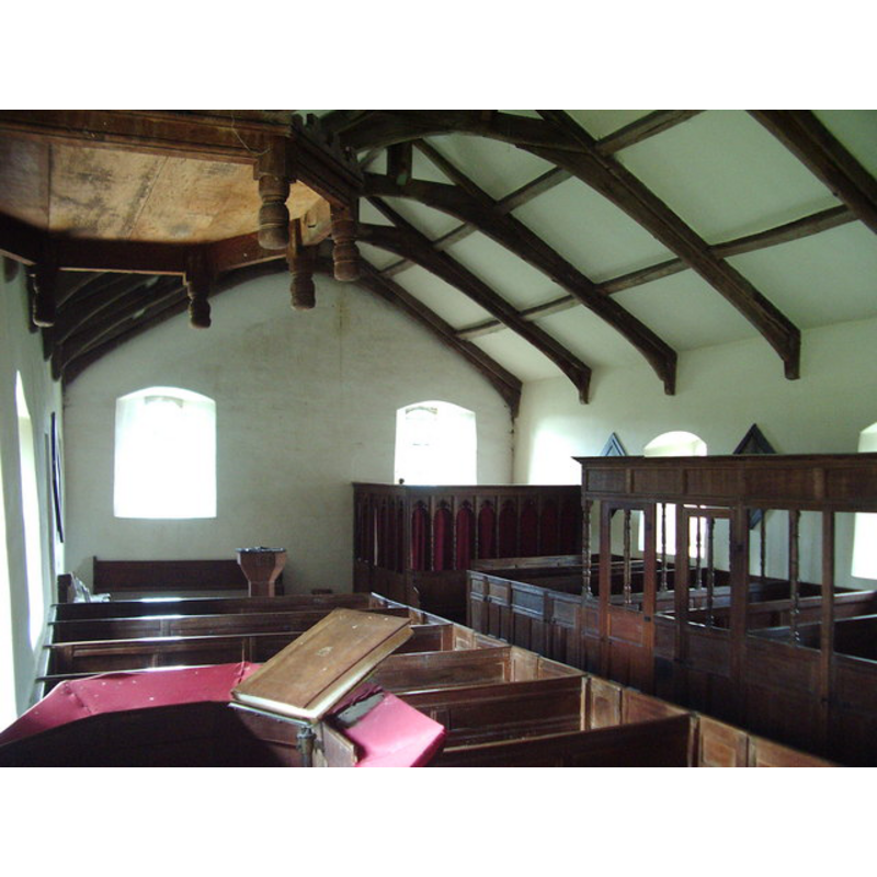
Copyright Statement: Image copyright © Alexander P Kapp, 2006
Image Source: digital photograph taken 24 August 2006 by Alexander P Kapp [www.geograph.org.uk/photo/227248] [accessed 25 October 2013]
Copyright Instructions: CC-BY-SA-2.0
view of church interior - nave - looking east
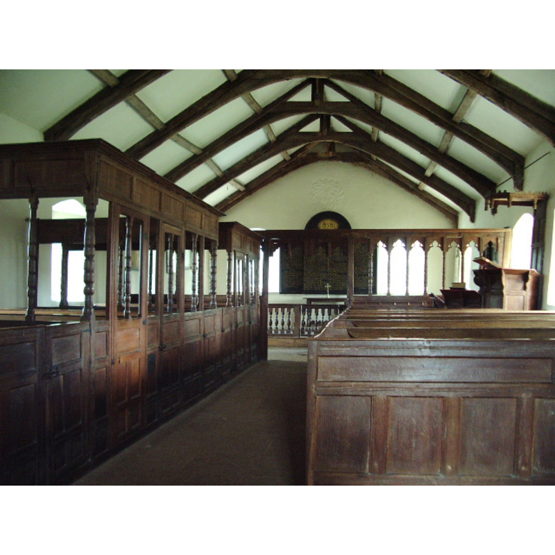
Copyright Statement: Image copyright © Alexander P Kapp, 2006
Image Source: digital photograph taken 24 August 2006 by Alexander P Kapp [www.geograph.org.uk/photo/227243] [accessed 25 October 2013]
Copyright Instructions: CC-BY-SA-2.0
view of font and cover

Copyright Statement: Image copyright © Sheeepdog Rex [Rex Harris, 2012
Image Source: digital photograph taken 25 June 2012 by Sheeepdog Rex [Rex Harris] [www.flickr.com/photos/sheepdog_rex/7472662988/] [accessed 25 October 2013]
Copyright Instructions: PERMISSION NOT AVAILABLE -- IMAGE NOT FOR PUBLIC USE
inscription
Scene Description: "1662"
Copyright Statement: Image copyright © Sheeepdog Rex [Rex Harris, 2012
Image Source: digital photograph taken 25 June 2012 by Sheeepdog Rex [Rex Harris] [www.flickr.com/photos/sheepdog_rex/7472662988/] [accessed 25 October 2013]
Copyright Instructions: PERMISSION NOT AVAILABLE -- IMAGE NOT FOR PUBLIC USE
INFORMATION
Font ID: 11039BRO
Object Type: Baptismal Font1
Font Date: 1662
Font Century and Period/Style: 17th century(mid), Restoration
Church / Chapel Name: Parish Church of St. Ninian [aka Ninekirk / Ninekirks] [redundant]
Font Location in Church: Inside the church, at the W end of the nave,
Church Patron Saint(s): St. Ninian [aka Nynia]
Church Notes: redundant; now in the care of the Churches Conservation Trust
Church Address: Brougham, Cumbria CA10 2AD
Site Location: Cumbria, North West, England, United Kingdom
Directions to Site: The church is located about 3 km NE of the Castle
Ecclesiastic Region: Diocese of Carlisle
Historical Region: formerly Westmoreland
Additional Comments: disappeared font? (the original one replaced by a plain 17th-century one -- there may have been a British Roman church here)
Font Notes:
Click to view
Curwen (1932) writes: "This church is now in a very remote part of the parish, far away from any houses, in the centre of a field. The dedication to a British Saint appears to indicate that it stands upon the site of a RomanoBritish foundation [cf. infra] But the first mention that we have of it is found in the "Antique Taxatio Ecclesiastica" of Pope Nicholas iv, made in 1291" [...] The Commonwealth Survey of 1657 gives the following: [...] 'The church was "repaired and new built frõ the ground or such ruins as threatened to lay it there," by the Lady Anne in 1660, and she records that it "would in all likelyhood have fallen downe, it was soe ruinous, if it had not bin now repaired by me." Fortunately the interior has not been restored materially since. Her initials and the date, 1660, are in relief plaster work at the east end. The date of the font is 1662 and that on the quaint poorbox is 1663.'" Robert de Appleby, 1310, is given in Curwen (ibid.) as the first recorded incumbent here. Noted in Pevsner (1967): "Font. 1662, plain, octagonal." Illustrated in Byner (2013). [NB: this font appears to date from the complete rebuilding of the original Norman church by Lady Anne Clifford [aka Anne Pembroke]. There may have been a much earlier church here; the Ancient Monuments site [www.ancientmonuments.info/en23678-st-ninian-s-preconquest-monastic-site-site] [accessed 25 October 2013] notes: "St Ninian's Preconquest Monastic Site, Site of Nucleated Medieval Settlement, St Ninian's Church and Churchyard" [WGS84 Coordinates: 54.6629, -2.68127 -- Grid Reference
SJ561561 (356060, 529986)], where it reports the presence of "A possible Roman altar is situated in the SE of St Ninian's Church. The altar measures 14.75" by 6" with concave sides." -- we have no information on the earlier font[s]. [cf. Index entry for Brougham No. 2 for a font possibly of the 17th century in St. Wilfrid's Chapel nearby]
SJ561561 (356060, 529986)], where it reports the presence of "A possible Roman altar is situated in the SE of St Ninian's Church. The altar measures 14.75" by 6" with concave sides." -- we have no information on the earlier font[s]. [cf. Index entry for Brougham No. 2 for a font possibly of the 17th century in St. Wilfrid's Chapel nearby]
COORDINATES
UTM: 30U 520338 6057315
Latitude & Longitude (Decimal): 54.6628, -2.6847
Latitude & Longitude (DMS): 54° 39′ 46.08″ N, 2° 41′ 4.92″ W
MEDIUM AND MEASUREMENTS
Material: stone
Font Shape: octagonal, mounted
Basin Interior Shape: round
Basin Exterior Shape: octagonal
INSCRIPTION
Inscription Language: numbers
Inscription Location: on one of the sides of the basin
Inscription Text: "1662"
LID INFORMATION
Material: wood
Apparatus: no
Notes: octagonal and flat, with metal decoration
REFERENCES
- Byrne, Matthew, Beautiful churches saved by The Churches Conservation Trust, London: Frances Lincoln, 2013, p. 83-88
- Curwen, John F., The Later Records relating to North Westmorland: or the Barony of Appleby, Kendal: T. Wilson, 1932, p. 278-290 / [www.british-history.ac.uk/report.aspx?compid=43519] [accessed 25 October 2013]
- Pevsner, Nikolaus, Cumberland and Westmorland, Harmondsworth: Penguin Books, 1967, p. 234