Stoak / Stoke
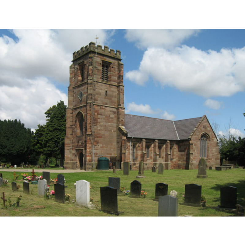
Image copyright © Sue Adair, 2009
CC-BY-SA-3.0
Results: 2 records
view of church exterior - southwest view
Copyright Statement: Image copyright © Sue Adair, 2009
Image Source: digital photograph taken 9 July 2009 by Sue Adair [www.geograph.org.uk/photo/1407356] [accessed 11 December 2012]
Copyright Instructions: CC-BY-SA-3.0
design element - architectural - arcade - blind
![described in Ormerod as "tall narrow Saxon arches" [cf. Font notes]](/static-50478a99ec6f36a15d6234548c59f63da52304e5/others/image_not_available.jpg)
Scene Description: described in Ormerod as "tall narrow Saxon arches" [cf. Font notes]
![described in Ormerod as "tall narrow Saxon arches" [cf. Font notes]](/static-50478a99ec6f36a15d6234548c59f63da52304e5/bsi-testing-site/others/image_not_available.jpg)
INFORMATION
Font ID: 10774STO
Object Type: Baptismal Font1
Font Century and Period/Style: 11th - 12th century, Pre-Conquest? / Norman?
Church / Chapel Name: Parish Church of St. Lawrence
Font Location in Church: [cf. FontNotes]
Church Patron Saint(s): St. Lawrence [aka Laurence]
Church Address: Church Lane, Stoak, Cheshire, CH2 4HP
Site Location: Cheshire, North West, England, United Kingdom
Directions to Site: Located near the M56-M53 junction, NNE of Chester
Ecclesiastic Region: Diocese of Chester
Historical Region: Hundred of Wirral
Additional Comments: destroyed font: destroyed by workmen lighting a fire in it -- MUST USE
Font Notes:
Click to view
Ellis (1902) writes: "In the works of Ormerod and Mortimer only three of the Wirral fonts are noticed, and both authors refer to the one at Stoke, which is described by Ormerod as circular, about three feet high, and rather more than two feet in diameter, ornamented round the sides with a series of tall and narrow Saxon arches (Hist. Ches. ii, 390). Not having seen any trace of an ancient font on my visit to the church, I made inquiry from the vicar, the Rev. R.W. Pritchard, who informed me that the old font was 'destroyed many years ago, by some workmen stupidly lighting a fire in it, while the church was under repair." An appendix by Crossley in Richards (1973) quotes Ormerod's description of ca. 1882: "At the west end, under a rude oaken gallery dated 1679, is a circular font, about three feet in height and rather more than two feet in diameter, ornamented round the sides with a series of tall narrow Saxon arches." Crossley (ibid.) then quotes from a Ellis [cf. supra].
COORDINATES
UTM: 30U 509024 5900187
Latitude & Longitude (Decimal): 53.250872, -2.864743
Latitude & Longitude (DMS): 53° 15′ 3.14″ N, 2° 51′ 53.08″ W
MEDIUM AND MEASUREMENTS
Material: stone
Font Shape: cylindrical
Basin Interior Shape: round
Basin Exterior Shape: round
Diameter (includes rim): 60+ cm*
Font Height (less Plinth): 90 cm*
Notes on Measurements: * [given in Richards (1973: 431), after Ormerod (1882), as "about three feet in height and rather more than two feet in diameter"
REFERENCES
- Ellis, John W., "The Mediaeval Fonts of the Hundreds of West Derby and Wirral", LVIII (New series: XVII), Transactions of the Historic Society of Lancashire and Cheshire, 1902, pp. 59-80; p. 77, 80
- Ormerod, George, The History of the county palatine and city of Chester, [...], Manchester: E.J. Morten, 1980 c1882, vol. II: 389-390
- Richards, Raymond, Old Cheshire churches: a survey of their history, fabric and furniture with records of the older monuments, with a supplementary survey relating to the lesser old chapels of Cheshire, Didsbury, Manchester: E.J. Morten, 1973, p. 431