Meldreth / Melrede
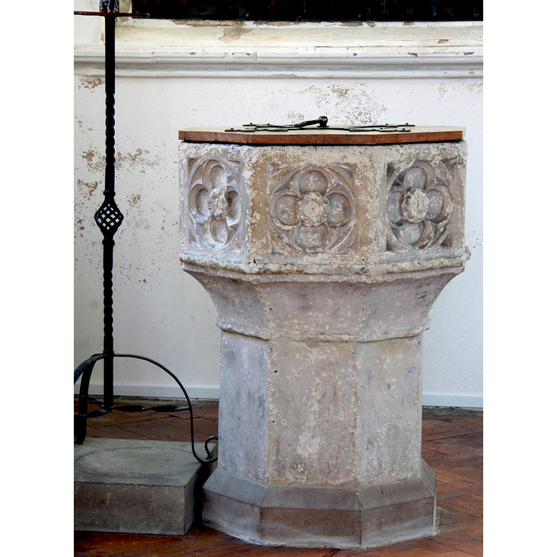
Image copyright © John Salmon, 2011
CC-BY-SA-2.0
Results: 6 records
view of font and cover
Copyright Statement: Image copyright © John Salmon, 2011
Image Source: digital photograph taken 24 February 2011 by John Salmon [www.geograph.org.uk/photo/2294854] [accessed 7 June 2016]
Copyright Instructions: CC-BY-SA-2.0
design element - motifs - floral - rose - in a quatrefoil - in a circle - 8
Scene Description: EXT SE digital photograph taken 4 March 2014 by John Sutton [www.geograph.org.uk/photo/3872255] [accessed 7 June 2016]
EXT SW digital photograph taken 29 February 2012 by David Purchase [www.geograph.org.uk/photo/2828832] [accessed 7 June 2016]
INT E digital photograph taken 24 February 2011 by John Salmon [www.geograph.org.uk/photo/2294843] [accessed 7 June 2016]
INT W digital photograph taken 24 February 2011 by John Salmon [www.geograph.org.uk/photo/2294849] [accessed 7 June 2016]
FONT digital photograph taken 24 February 2011 by John Salmon [www.geograph.org.uk/photo/2294854] [accessed 7 June 2016]
Copyright Statement: Image copyright © John Salmon, 2011
Image Source: digital photograph taken 24 February 2011 by John Salmon [www.geograph.org.uk/photo/2294854] [accessed 7 June 2016]
Copyright Instructions: CC-BY-SA-2.0
view of church exterior - southwest view
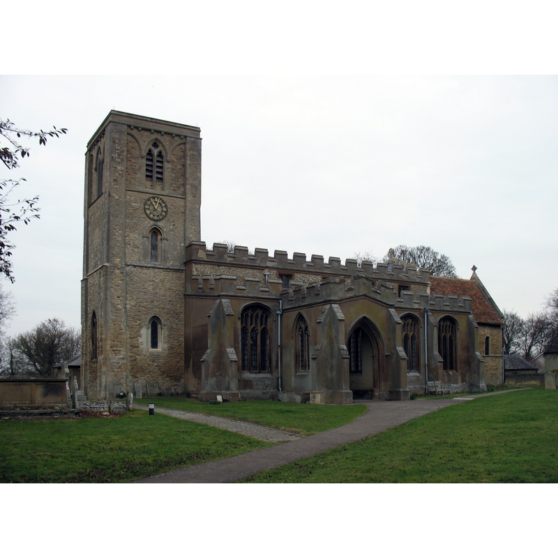
Copyright Statement: Image copyright © David Purchase, 2012
Image Source: digital photograph taken 29 February 2012 by David Purchase [www.geograph.org.uk/photo/2828832] [accessed 7 June 2016]
Copyright Instructions: CC-BY-SA-2.0
view of church exterior - southeast view
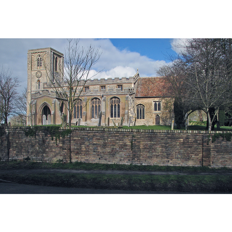
Copyright Statement: Image copyright © John Sutton, 2014
Image Source: digital photograph taken 4 March 2014 by John Sutton [www.geograph.org.uk/photo/3872255] [accessed 7 June 2016]
Copyright Instructions: CC-BY-SA-2.0
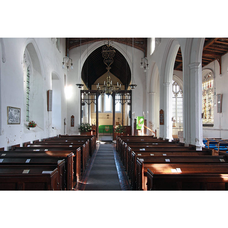
view of church interior - nave - looking west
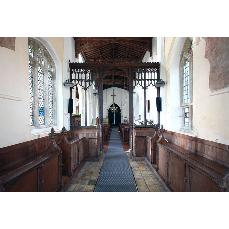
Copyright Statement: Image copyright © John Salmon, 2011
Image Source: digital photograph taken 24 February 2011 by John Salmon [www.geograph.org.uk/photo/2294849] [accessed 7 June 2016]
Copyright Instructions: CC-BY-SA-2.0
view of church interior - nave - looking east
Scene Description: the font is partially visible at the east end of the south aisle
Copyright Statement: Image copyright © John Salmon, 2011
Image Source: digital photograph taken 24 February 2011 by John Salmon [www.geograph.org.uk/photo/2294843] [accessed 7 June 2016]
Copyright Instructions: CC-BY-SA-2.0
INFORMATION
Font ID: 10717MEL
Object Type: Baptismal Font1
Font Century and Period/Style: 14th - 15th century, Perpendicular
Church / Chapel Name: Parish Church of the Holy Trinity
Font Location in Church: Inside the church, at the E end of the S aisle [not its original position]
Church Patron Saint(s): The Holy Trinity
Church Address: 35 N End Road, Meldreth, Cambridgeshire SG8 6NR
Site Location: Cambridgeshire, East, England, United Kingdom
Directions to Site: Located off the A10, just NNW of Melbourn, 16 km SW of Cambridge
Ecclesiastic Region: Diocese of Ely
Historical Region: Hundred of Arringford
Additional Comments: altered font / moved font (the lower base and plinth of the present font have been replaced or added) -- disappeared fonts? (the ones from the two Domesday-time churches here)
Font Notes:
Click to view
There are nine entries for Meldreth [variant spelling] in the Domesday survey [http://opendomesday.org/place/TL3746/meldreth/] [accessed 7 June 2016], two which mention a church in each; four priests altogether are noted as being lords in 1066: Leofwin, Edric, Almer and Godwin. Interestingly none of them appear as either lords or tenants in 1086. The English Heritage entry for this church [Listing NGR: TL3777746837] (1967) reports: "Font C14. Octagonal bowl of limestone on octagonal stem. Quatrefoils carved to each face of bowl." Pevsner (1970) writes: "Font. Octagonal, Perp[endicular], with quatrefoil panels." The Victoria County History (Cambridge, vol. 8, 1982) notes: "In 1066 a church or monasterium at Meldreth belonged to Ely abbey. The five priests there, who were sokemen of Ely, probably served that small minster. [...] After the priests mentioned in 1066 no rector is recorded until the late 12th century. [...] The unusually long [present] chancel dates from the 12th century and perhaps echoes the size of an earlier minster"; no font is mentioned in the VCH entry for this parish.
COORDINATES
UTM: 31U 295232 5776674
Latitude & Longitude (Decimal): 52.102655, 0.010062
Latitude & Longitude (DMS): 52° 6′ 9.56″ N, 0° 0′ 36.22″ E
MEDIUM AND MEASUREMENTS
Material: stone
Font Shape: octagonal, mounted
Basin Interior Shape: round
Basin Exterior Shape: octagonal
LID INFORMATION
Date: modern
Material: wood, oak
Apparatus: no
Notes: octagonal and flat, with metal decoration and ring handle; modern
REFERENCES
- Victoria County History [online], University of London, 1993-. URL: https://www.british-history.ac.uk.
- Pevsner, Nikolaus, Cambridgeshire, Harmonsworth: Penguin, 1970, p. 441