Waresley / Wedreslei / Wereslai / Werisleg / Werisley
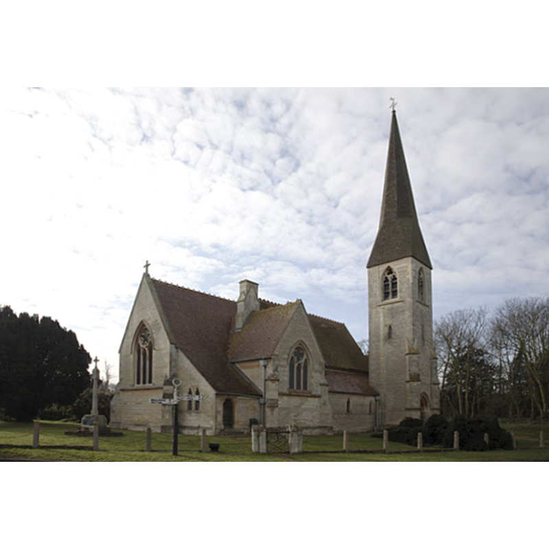
Image copyright © Martin John Bishop, 2007
CC-BY-SA-3.0
Results: 3 records
view of church exterior - northeast view
Copyright Statement: Image copyright © Martin John Bishop, 2007
Image Source: digital photograph taken 6 February 2007 by Martin John Bishop [www.geograph.org.uk/photo/331410] [accessed 24 April 2012]
Copyright Instructions: CC-BY-SA-3.0
view of font

Scene Description: the modern font; the modern cover behind the font
Copyright Statement: Image copyright © Brentorboxer, 2012
Image Source: digital photograph by Brentorboxer [www.waymarking.com/waymarks/WM85QV_Font_St_James_Church_Waresley_Cambridgeshire_UK] [accessed 24 April 2012]
Copyright Instructions: PERMISSION NOT AVAILABLE -- IMAGE NOT FOR PUBLIC USE
view of font and cover in context
Scene Description: the modern font and cover at the west end of the nave
Copyright Statement: Image copyright © Brentorboxer, 2012
Image Source: digital photograph by Brentorboxer [www.waymarking.com/waymarks/WM85QV_Font_St_James_Church_Waresley_Cambridgeshire_UK] [accessed 24 April 2012]
Copyright Instructions: PERMISSION NOT AVAILABLE -- IMAGE NOT FOR PUBLIC USE
INFORMATION
Font ID: 10687WAR
Object Type: Baptismal Font1
Font Century and Period/Style: 11th century, Medieval
Church / Chapel Name: Old Parish Church of St. James the Great [earlier St. Andrew's] [destroyed in 1724]
Church Patron Saint(s): St. James the Greater [aka James the Great, James the Elder] [the earlier church had been originally dedicated to St. Andrew]
Church Address: Waresley, Cambridgeshire SG19 3BS
Site Location: Cambridgeshire, East, England, United Kingdom
Directions to Site: Located on the B1040, just S of the crossing with the B1046, 4 km NE of Gamlingay, SW of Cambridge
Ecclesiastic Region: Diocese of Ely
Historical Region: formerly Huntingdonshire -- Hundred of Toseland
Additional Comments: destroyed font? (the earlier church was destoyed by a storm in 1724 [cf. FontNotes])
Font Notes:
Click to view
The Victoria County History (Huntingdon, vol. 2, 1932) notes: "The church and priest of Waresley are mentioned in Domesday Book (1086) [...] The ancient church which appears to have been dedicated to St. Andrew, but later was generally spoken of as St. James the Great, stood at the east end of the village. (fn. 72) It was destroyed by a storm in 1724, and in 1728 was rebuilt [...] This church was pulled down and a new church built on another site in 1856"; there is no mention of a font in the VCH entry for this parish. Pevsner (1968) (after GMCH) notes an "excellent and typical" font cover, but does not mention the font.
COORDINATES
UTM: 30U 693298 5784286
Latitude & Longitude (Decimal): 52.17514, -0.172998
Latitude & Longitude (DMS): 52° 10′ 30.5″ N, 0° 10′ 22.79″ W
LID INFORMATION
Notes: [cf. FontNotes]
REFERENCES
- Victoria County History [online], University of London, 1993-. URL: https://www.british-history.ac.uk.
- Pevsner, Nikolaus, Bedfordshire and the County of Huntingdon and Peterborough, Harmondsworth: Penguin, 1968, p. 363