Upwood / Upehude / Upwode / Upwude
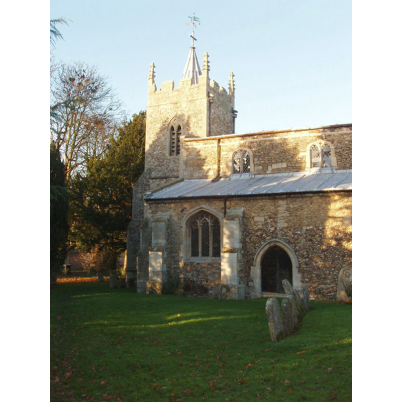
Image copyright © David Hawgood, 2006
CC-BY-SA-3.0
Results: 3 records
view of church exterior - southwest end
Copyright Statement: Image copyright © David Hawgood, 2006
Image Source: digital photograph taken 28 November 2006 by David Hawgood [www.geograph.org.uk/photo/287089] [accessed 23 April 2012]
Copyright Instructions: CC-BY-SA-3.0
view of font

Copyright Statement: Image copyright © The British Academy & Ron Baxter, 2004
Image Source: The Corpus of Romanesque Sculpture in Britain and Ireland [www.crsbi.ac.uk/ed/hu/upwoo/]
Copyright Instructions: PERMISSION NOT AVAILABLE -- IMAGE NOT FOR PUBLIC USE
view of church interior
Scene Description: View of church interior ca. 1930
Copyright Statement: Image copyright © http://pages.britishlibrary.net/ramseyteam/USPpages2/usppicknave.htm, [2004?]
Copyright Instructions: PERMISSION NOT AVAILABLE -- IMAGE NOT FOR PUBLIC USE
INFORMATION
Font ID: 10686UPW
Object Type: Baptismal Font1
Font Date: ca. 1150?
Font Century and Period/Style: 12th century (mid?), Medieval [composite]
Church / Chapel Name: Parish Church of St. Peter
Font Location in Church: Inside the church, S aisle, near the S door
Church Patron Saint(s): St. Peter
Church Address: 2 Church Lane, Upwood, Cambridgeshire PE26 2QE
Site Location: Cambridgeshire, East, England, United Kingdom
Directions to Site: Located off the B1040, 3 km SW of Ramsey
Ecclesiastic Region: Diocese of Ely
Historical Region: formerly Huntingdonshire -- Hundred of Hurstingstone
Additional Comments: altered font: the base is modern -- damaged font: damage to the upper basin side
Font Notes:
Click to view
Noted in the RCHM (1926). The Victoria County History (Huntingdon, vol. 2, 1932) writes: "Of the church mentioned in the Domesday Survey (1086), which was probably of timber, nothing remains, but about the year 1100 a stone church consisting of a chancel and an aisle-less nave was built, of which the chancel arch and part of the north wall of the nave remain. Some fifty years later the chancel was rebuilt and widened and an arcade cut into the nave wall and a north aisle built. [...] The font is a plain square bowl possibly of c. 1150, on a modern stem and base; it has a 17th-century pyramidal oak cover." Pevsner (1968) [after the RCHM, 1926] notes only the font cover: "Jacobean, with nicely decorated ribs". In the CRSBI (2008): Romanesque square basin mounted on a modern pedestal; the CRSBI notes the repairs to the upper rim of the basin, "testifying the removal of a lock".
COORDINATES
UTM: 30U 693780 5812342
Latitude & Longitude (Decimal): 52.426897, -0.149809
Latitude & Longitude (DMS): 52° 25′ 36.83″ N, 0° 8′ 59.31″ W
MEDIUM AND MEASUREMENTS
Material: stone
Font Shape: square, mounted
Basin Interior Shape: round
Basin Exterior Shape: square
Drainage Notes: lead lining
Diameter (inside rim): 59 cm*
Height of Basin Side: 33 cm*
Basin Total Height: 33 cm*
Trapezoidal Basin: 71.5 x 73 cm*
Notes on Measurements: * [CRSBI (2008)]
LID INFORMATION
Date: Jacobean / 17th century?
Material: wood, oak
Notes: [cf. FontNotes]
REFERENCES
- Victoria County History [online], University of London, 1993-. URL: https://www.british-history.ac.uk.
- Corpus of Romanesque Sculpture in Britain and Ireland, The Corpus of Romanesque Sculpture in Britain and Ireland, The Corpus of Romanesque Sculpture in Britain and Ireland. URL: http://www.crsbi.ac.uk.
- Great Britain. Royal Commission on Historical Monuments, An Inventory of the Historical Monuments in Huntingdonshire, London: [The Commission], 1926, p. 280
- Pevsner, Nikolaus, Bedfordshire and the County of Huntingdon and Peterborough, Harmondsworth: Penguin, 1968, p. 360