Westoning / Weston / Weston Inge / Weston Tregoz / Westone
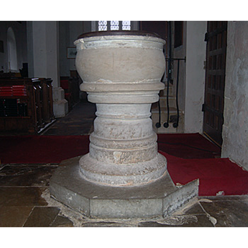
Image copyright © Bedford Borough Council, 2009
No known copyright restriction / Fair Dealing
Results: 5 records
view of font and cover
Copyright Statement: Image copyright © Bedford Borough Council, 2009
Image Source: digital photograph taken February 2010 in Bedford Borough Council [www.bedfordshire.gov.uk/CommunityAndLiving/ArchivesAndRecordOffice/CommunityArchives/Westoning/WestoningChurchArchitecture.aspx] [accessed 27 October 2011]
Copyright Instructions: No known copyright restriction / Fair Dealing
design element - motifs - roll moulding
Copyright Statement: Image copyright © Bedford Borough Council, 2009
Image Source: digital photograph taken February 2010 in Bedford Borough Council [www.bedfordshire.gov.uk/CommunityAndLiving/ArchivesAndRecordOffice/CommunityArchives/Westoning/WestoningChurchArchitecture.aspx] [accessed 27 October 2011]
Copyright Instructions: No known copyright restriction / Fair Dealing
design element - motifs - moulding
Copyright Statement: Image copyright © Bedford Borough Council, 2009
Image Source: digital photograph taken February 2010 in Bedford Borough Council [www.bedfordshire.gov.uk/CommunityAndLiving/ArchivesAndRecordOffice/CommunityArchives/Westoning/WestoningChurchArchitecture.aspx] [accessed 27 October 2011]
Copyright Instructions: No known copyright restriction / Fair Dealing
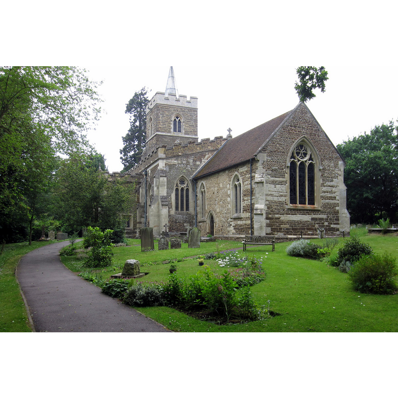
view of church exterior - southeast view
Copyright Statement: Image copyright © Philip Jeffrey, 2013
Image Source: digital photograph taken 18 June 2013 by Philip Jeffrey [www.geograph.org.uk/photo/3516210] [accessed 23 September 2015]
Copyright Instructions: CC-BY-SA-2.0
design element - motifs - moulding
Scene Description: several
Copyright Statement: Image copyright © Bedford Borough Council, 2009
Image Source: digital photograph taken February 2010 in Bedford Borough Council [www.bedfordshire.gov.uk/CommunityAndLiving/ArchivesAndRecordOffice/CommunityArchives/Westoning/WestoningChurchArchitecture.aspx] [accessed 27 October 2011]
Copyright Instructions: No known copyright restriction / Fair Dealing
INFORMATION
Font ID: 10638WES
Object Type: Baptismal Font1
Font Century and Period/Style: 13th century [composite font?], Medieval [composite]
Church / Chapel Name: Parish Church of St. Mary Magdalene
Font Location in Church: Inside the church, at the W end, by the S doorway
Church Patron Saint(s): St. Mary Magdalene
Church Address: Church Road, Westoning, Bedfordshire MK45 5JW
Site Location: Bedfordshire, East, England, United Kingdom
Directions to Site: Located off (W) the A5120, 6-7 km SSW of Ampthill, SSW of Bedford
Ecclesiastic Region: Diocese of St. Albans
Historical Region: Hundred of Hitchin [in Domesday] -- Hundred of Manshead
Additional Comments: disappeared font? (the one from the original 12thC church here)
Font Notes:
Click to view
There is an entry for Westoning [variant spelling] in the Domesday survey [http://opendomesday.org/place/TL0232/westoning/] [accessed 23 September 2015], but it mentions neither cleric nor church in it. The Victoria County History (Bedfordshire, vol. 3, 1912) notes: "The church of Westoning was granted to the nuns of Elstow by Henry II [1154-1189] with the church of Hitchin in Hertfordshire. [...] In 1291 its value was £4 6s. 8d [...] A few late 12th-century carved stones are built into the inside of the south aisle wall, and a good deal of ruined material of this date is to be seen elsewhere, but the church seems to have been entirely rebuilt at the beginning of the 14th century on the existing plan [...] The base of the font appears to be a 13th-century capital placed directly on the pavement, and may have belonged to the nave arcade of an earlier church; the bowl is round." Noted in Pevsner (1968): "Font. Cauldron-shaped, with big bold rolls -- obviously C13." The wooden cover is round and flat; appears modern. The whole is raised on a modern polygonal plinth. [NB: we have no information on the font from the earlier church here].
COORDINATES
UTM: 30U 671415 5762218
Latitude & Longitude (Decimal): 51.984148, -0.503775
Latitude & Longitude (DMS): 51° 59′ 2.93″ N, 0° 30′ 13.59″ W
MEDIUM AND MEASUREMENTS
Material: stone
Font Shape: cauldron-shaped, mounted
Basin Interior Shape: round
Basin Exterior Shape: round
LID INFORMATION
Date: modern?
Material: wood, oak?
Apparatus: no
Notes: [cf. FontNotes]
REFERENCES
- Victoria County History [online], University of London, 1993-. URL: https://www.british-history.ac.uk.
- Pevsner, Nikolaus, Bedfordshire and the County of Huntingdon and Peterborough, Harmondsworth: Penguin, 1968, p. 162