Holwell nr. Hitchin / Holewelle
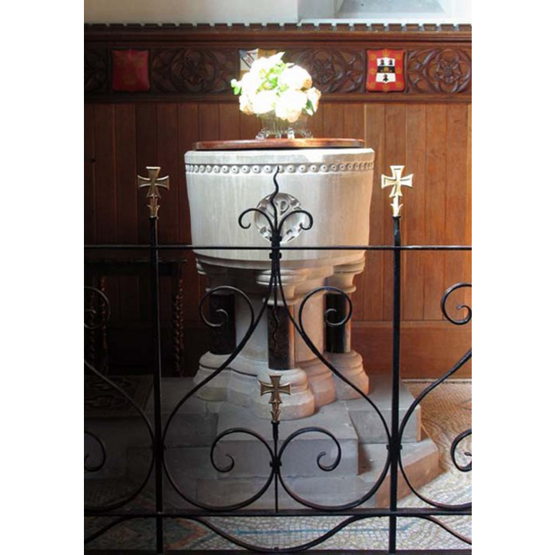
Image copyright © John Salmon, 2007
CC-BY-SA-3.0
Results: 4 records
view of font and cover
Scene Description: the modern font [cf. FontNotes]
Copyright Statement: Image copyright © John Salmon, 2007
Image Source: digital photograph taken 18 May 2007 by John Salmon [www.geograph.org.uk/photo/471803] [accessed 9 May 2012]
Copyright Instructions: CC-BY-SA-3.0
view of church exterior - southwest view
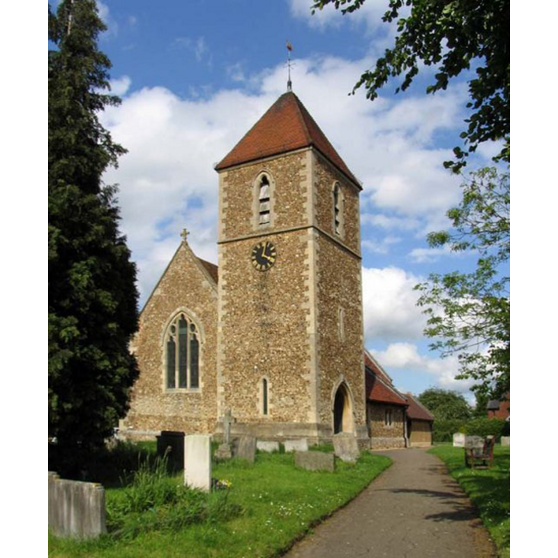
Copyright Statement: Image copyright © John Salmon, 2007
Image Source: digital photograph taken 18 May 2007 by John Salmon [www.geograph.org.uk/photo/471793] [accessed 9 May 2012]
Copyright Instructions: CC-BY-SA-3.0
view of church exterior - northwest view
![EXT NW digital photograph taken 18 May 2007 by John Salmon [www.geograph.org.uk/photo/471792] [accessed 9 May 2012]
EXT SW digital photograph taken 18 May 2007 by John Salmon [www.geograph.org.uk/photo/471793] [accessed 9 May 2012]
INT EAST digital photograph taken 18 May 2007 by John Salmon [www.geograph.org.uk/photo/471800] [accessed 9 May 2012]
FONT the modern font digital photograph taken 18 May 2007 by John Salmon [www.geograph.org.uk/photo/471803] [accessed 9 May 2012]](/static-50478a99ec6f36a15d6234548c59f63da52304e5/compressed/1120509004_compressed.png)
Scene Description: EXT NW digital photograph taken 18 May 2007 by John Salmon [www.geograph.org.uk/photo/471792] [accessed 9 May 2012]
EXT SW digital photograph taken 18 May 2007 by John Salmon [www.geograph.org.uk/photo/471793] [accessed 9 May 2012]
INT EAST digital photograph taken 18 May 2007 by John Salmon [www.geograph.org.uk/photo/471800] [accessed 9 May 2012]
FONT the modern font digital photograph taken 18 May 2007 by John Salmon [www.geograph.org.uk/photo/471803] [accessed 9 May 2012]
Copyright Statement: Image copyright © John Salmon, 2007
Image Source: digital photograph taken 18 May 2007 by John Salmon [www.geograph.org.uk/photo/471792] [accessed 9 May 2012]
Copyright Instructions: CC-BY-SA-3.0
view of church interior - southwest view
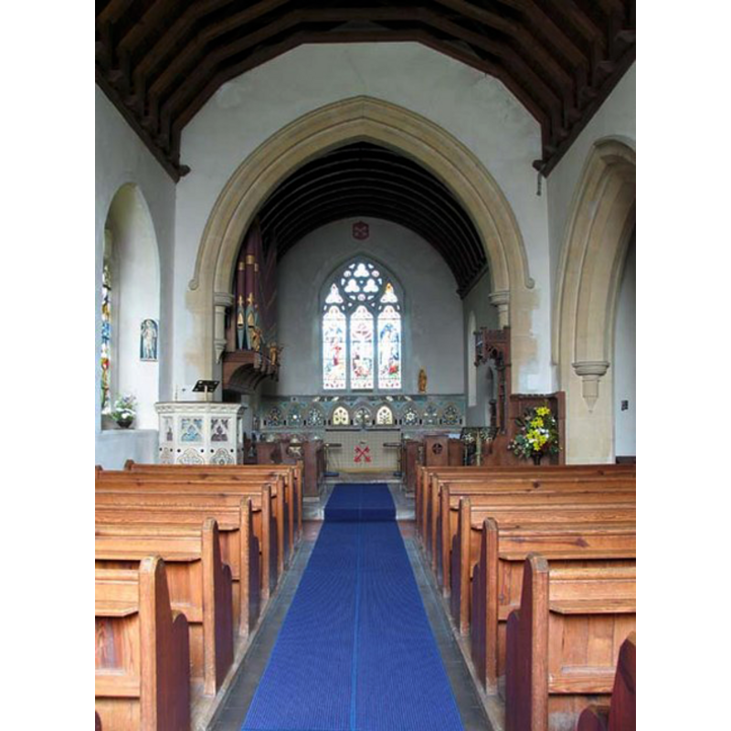
Copyright Statement: Image copyright © John Salmon, 2007
Image Source: digital photograph taken 18 May 2007 by John Salmon [www.geograph.org.uk/photo/471800] [accessed 9 May 2012]
Copyright Instructions: CC-BY-SA-3.0
INFORMATION
Font ID: 10617HOL
Object Type: Baptismal Font1
Font Century and Period/Style: 12th - 13th century, Early English
Cognate Fonts: Eaton Bray and Leighton Buzzard, in the same county; also Belaugh, in Norfolk
Church / Chapel Name: Parish Church of St. Peter
Font Location in Church: [cf. FontNotes]
Church Patron Saint(s): St. Peter
Church Address: Holwell Road, Holwell, Hertfordshire SG5 3SS
Site Location: Hertfordshire, East, England, United Kingdom
Directions to Site: Located off the A600, 6 km NNW of Hitchin, 7 km S of Shefford, W of Letchworth
Ecclesiastic Region: Diocese of St. Albans
Historical Region: formerly in Bedfordshire -- Hundred of Clifton
Additional Comments: disappeareed font? (the medieval font here?) -- Holwell was transferred, since the survey of 1831, from Bedfordshire to Hertfordshire.
Font Notes:
Click to view
Noted in Lysons (1806-1833) as one of a group of circular fonts: “in the shape of a bason standing on five pillars, some of which have capitals of foliage” [Leighton Buzzard and Eaton Bray are two others in this group]. The Victoria County History (Bedford, vol. 2, 1908) notes: "The church of St. Peter was entirely rebuilt in 1877 [...] A few pieces of old work have been re-used, the most interesting being the string across the inner face of the east wall of the chancel. This is of fourteenthcentury date [...] The registers begin in 1560"; the VCH entry does not mention a font in this church. The modern font, probably of the late-19th century re-building of this church, consists of a cylindrical basin raised on four marble columns, and is located in an alcove or enclosure behind a railing. [NB: we have no information on the whereabouts of the medieval font seen by Lysons before the 1877 renovation of the church].
COORDINATES
UTM: 30U 685109 5762926
Latitude & Longitude (Decimal): 51.98612, -0.3042
Latitude & Longitude (DMS): 51° 59′ 10.03″ N, 0° 18′ 15.12″ W
MEDIUM AND MEASUREMENTS
Material: stone, limestone?
Font Shape: hemispheric, mounted
Basin Interior Shape: round
Basin Exterior Shape: round
REFERENCES
- Victoria County History [online], University of London, 1993-. URL: https://www.british-history.ac.uk.
- Lysons, Daniel, Magna Britannia, being a concise topographical account of the several counties of Great Britain, London: Printed for T. Cadell and W. Davies, 1806-1822, vol. I: p. 31-32