Wingrave / Withungrave / Witungrave / Wiungraua / Wiungrava
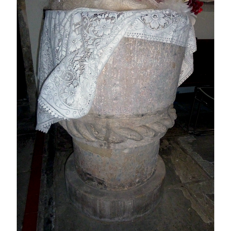
Image copyright © Rob Farrow, 2014
CC-BY-SA-2.0
Results: 5 records
view of font
Copyright Statement: Image copyright © Rob Farrow, 2014
Image Source: digital photograph taken 29 December 2014 by Rob Farrow [www.geograph.org.uk/photo/4311272] [accessed 24 November 2015]
Copyright Instructions: CC-BY-SA-2.0
view of font and cover
Copyright Statement: Image copyright © John Salmon, 2011
Image Source: digital photograph taken 10 September 2011 by John Salmon [www.geograph.org.uk/photo/2610861] [accessed 24 November 2015]
Copyright Instructions: CC-BY-SA-2.0
design element - motifs - rope moulding
Copyright Statement: Image copyright © John Salmon, 2011
Image Source: digital photograph taken 10 September 2011 by John Salmon [www.geograph.org.uk/photo/2610861] [accessed 24 November 2015]
Copyright Instructions: CC-BY-SA-2.0
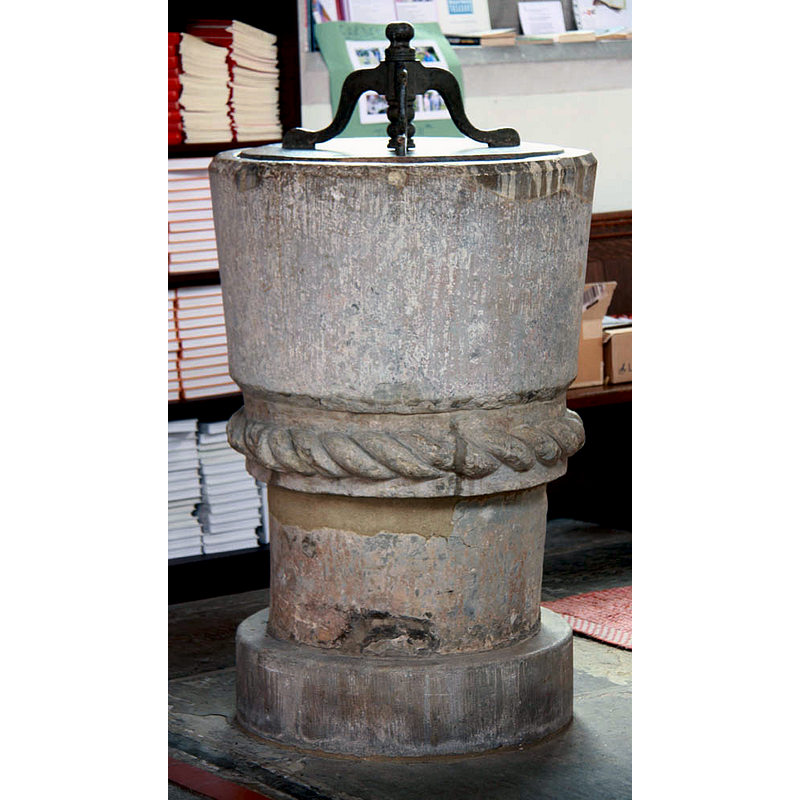
view of basin - detail
Scene Description: a number of new-stone insert repairs are visible around the upper rim area
Copyright Statement: Image copyright © John Salmon, 2011
Image Source: digital photograph taken 10 September 2011 by John Salmon [www.geograph.org.uk/photo/2610861] [accessed 24 November 2015]
Copyright Instructions: CC-BY-SA-2.0
view of church exterior - southeast view
![*********************REPLACE N PICS IF NECESSARY********************
EXT SE digital photograph taken 10 September 2011 by John Salmon [www.geograph.org.uk/photo/2610835] [accessed 24 November 2015]
INT E digital photograph taken 29 December 2014 by Rob Farrow [www.geograph.org.uk/photo/4310731] [accessed 24 November 2015] Source caption: "Wingrave - SS Peter & Paul - Nave. A view eastwards along the nave. The nave has 5 bays of C14th double chamfered arches on octagonal piers. There are interesting C15th carved carved stone corbels to the descending roof trusses with C15th wooden figures above them.
Beyond the double chamfered Chancel Arch lies the Chancel."
FONT+COVER SALMON digital photograph taken 10 September 2011 by John Salmon [www.geograph.org.uk/photo/2610861] [accessed 24 November 2015]
FONT digital photograph taken 29 December 2014 by Rob Farrow [www.geograph.org.uk/photo/4311272] [accessed 24 November 2015] Source caption: "Wingrave - SS Peter & Paul - Norman font. This quite plain Norman font has a band of rope-work (or cable moulding) between its bowl and stand - this is typical of the more ornate Aylesbury Fonts of this area, though this font is not considered to be one of them. Dating from the C12th it is at least as old as the oldest parts of the church in which it stands."](/static-50478a99ec6f36a15d6234548c59f63da52304e5/compressed/1151126001_compressed.png)
Scene Description: *********************REPLACE N PICS IF NECESSARY********************
EXT SE digital photograph taken 10 September 2011 by John Salmon [www.geograph.org.uk/photo/2610835] [accessed 24 November 2015]
INT E digital photograph taken 29 December 2014 by Rob Farrow [www.geograph.org.uk/photo/4310731] [accessed 24 November 2015] Source caption: "Wingrave - SS Peter & Paul - Nave. A view eastwards along the nave. The nave has 5 bays of C14th double chamfered arches on octagonal piers. There are interesting C15th carved carved stone corbels to the descending roof trusses with C15th wooden figures above them.
Beyond the double chamfered Chancel Arch lies the Chancel."
FONT+COVER SALMON digital photograph taken 10 September 2011 by John Salmon [www.geograph.org.uk/photo/2610861] [accessed 24 November 2015]
FONT digital photograph taken 29 December 2014 by Rob Farrow [www.geograph.org.uk/photo/4311272] [accessed 24 November 2015] Source caption: "Wingrave - SS Peter & Paul - Norman font. This quite plain Norman font has a band of rope-work (or cable moulding) between its bowl and stand - this is typical of the more ornate Aylesbury Fonts of this area, though this font is not considered to be one of them. Dating from the C12th it is at least as old as the oldest parts of the church in which it stands."
Copyright Statement: Image copyright © John Salmon, 2011
Image Source: digital photograph taken 10 September 2011 by John Salmon [www.geograph.org.uk/photo/2610835] [accessed 24 November 2015]
Copyright Instructions: CC-BY-SA-2.0
INFORMATION
Font ID: 10606WIN
Object Type: Baptismal Font1
Font Date: ca. 1190?
Font Century and Period/Style: 12th century (late?) [basin only] [composite font], Medieval [composite]
Church / Chapel Name: Parish Church of St. Peter and St. Paul
Font Location in Church: Inside the church
Church Patron Saint(s): St. Peter & St. Paul
Church Address: Winslow Road, Wingrave, Buckinghamshire HP22 4PE
Site Location: Buckinghamshire, South East, England, United Kingdom
Directions to Site: Located 5 km SW of Wing, 8 km NE of Aylesbury
Ecclesiastic Region: Diocese of Oxford
Historical Region: Hundred of Cottesloe
Additional Comments: altered font (stem and base are modern)
Font Notes:
Click to view
There are five entries for Wingrave [variant spelling] in the Domesday survey [http://opendomesday.org/place/SP8719/wingrave/] [accessed 24 November 2015], none of which mention cleric or church in it, except for the name of 'Turstin the priest', who is reported as lord here in 1086. Sheahan (1862) writes: "The font is large and circular, of equal size from top to bottom, and has no ornament or sculpture, save only a wreathed border or fillet, round its lower edge." The Victoria County History (Buckingham, vol. 3, 1925) notes: "The church dates from the latter part of the 12th century, and was probably built by William son of Alured de Wedon [...] The church was thoroughly restored in 1887–8 [...] and in 1898 the upper part of the tower was rebuilt [...] The font dates from the 12th century and is circular. Around the lower edge of the bowl, which is supported on a modern stem and base, is a cable moulding." Noted in Pevsner (1960): "Font. Circular, Norman, with one band of rope." The basin is bucket-shaped and plain, except for the thick rope moulding at the bottom; raised on a modern plain cylindrical pedestal base. [NB: Sheahan (ibid.) reports that the adjacent hamlet of Rowsham, part of the civil parish, had an medieval chapel dedicated to St. Lawrence, but had been destroyed "long since" Sheahan's time].
COORDINATES
UTM: 30U 655652 5748297
Latitude & Longitude (Decimal): 51.863724, -0.739416
Latitude & Longitude (DMS): 51° 51′ 49.4″ N, 0° 44′ 21.9″ W
MEDIUM AND MEASUREMENTS
Material: stone
Font Shape: bucket-shaped, mounted
Basin Interior Shape: round
Basin Exterior Shape: round
LID INFORMATION
Date: modern?
Material: wood
Apparatus: no
Notes: round, flat and plain; modern?
REFERENCES
- Victoria County History [online], University of London, 1993-. URL: https://www.british-history.ac.uk.
- Pevsner, Nikolaus, Buckinghamshire, Harmondsworth: Penguin, 1960, p. 297
- Sheahan, James Joseph, History and topography of Buckinghamshire, comprising a general survey of the county, preceded by an epitome of the early history of Great Britain, London; Pontefract: Longman, Green, Longman, and Roberts; William Edward Bonas [...], 1862, p. 789, 791