North Crawley / Crauelai [Domesday] / Craule / Crawele / Croule-juxta-Newport Pagnell / Crowle / Great Craule / North Crolye
![Main image for North Crawley / Crauelai [Domesday] / Craule / Crawele / Croule-juxta-Newport Pagnell / Crowle / Great Craule / North Crolye](/static-50478a99ec6f36a15d6234548c59f63da52304e5/compressed/1090412009_compressed.png)
Image copyright © LawrenceOP, 2008
CC-BY-SA-3.0
Results: 4 records
view of font and cover
Copyright Statement: Image copyright © LawrenceOP, 2008
Image Source: detail of a digital photograph taken 23 June 2008 by Lawrence OP [http://www.flickr.com/photos/paullew/2607135031/] [accessed 12 April 2009]
Copyright Instructions: CC-BY-SA-3.0
design element - motifs - moulding
Copyright Statement: Image copyright © LawrenceOP, 2008
Image Source: detail of a digital photograph taken 23 June 2008 by Lawrence OP [http://www.flickr.com/photos/paullew/2607135031/] [accessed 12 April 2009]
Copyright Instructions: CC-BY-SA-3.0
view of church exterior - south view
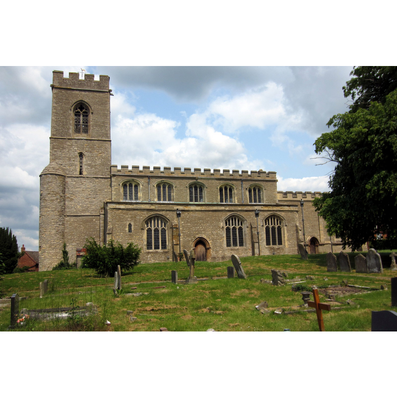
Copyright Statement: Image copyright © Philip Jeffrey, 2013
Image Source: digital photograph taken 26 June 2013 by Philip Jeffrey [www.geograph.org.uk/photo/3528838] [accessed 18 February 2016]
Copyright Instructions: CC-BY-SA-2.0
view of church interior - nave - looking west
Scene Description: the font and cover at the back
Copyright Statement: Image copyright © LawrenceOP, 2008
Image Source: digital photograph taken 23 June 2008 by Lawrence OP [http://www.flickr.com/photos/paullew/2607135031/] [accessed 12 April 2009]
Copyright Instructions: CC-BY-SA-3.0
INFORMATION
Font ID: 10601CRA
Object Type: Baptismal Font1
Font Century and Period/Style: 13th - 14th century, Early English? / Decorated?
Church / Chapel Name: Parish Church of St. Firmin
Font Location in Church: Inside the church, in the W end of the nave
Church Patron Saint(s): St. Firminus of Amiens [aka Fermin, Firmin]
Church Address: 2 High Street, North Crawley, Milton Keynes MK16 9LH
Site Location: Buckinghamshire, South East, England, United Kingdom
Directions to Site: Located 6 km WNW of Newport Pagnell, near the county border with Bedfordshire
Ecclesiastic Region: Diocese of Oxford
Historical Region: Houndred of Moulsoe [in Domesday] -- Hundred of Newport
Additional Comments: disappeared font? (the one from the original 11thC and 12thC church here)
Font Notes:
Click to view
No individual entry for [North] Crawley found in the Domesday survey. Parker (1850) writes: "Font plain, with a central shaft and clusterer shafts round it." Sheahan (1862) writes: "The font is ancient and curious, the large octangular basin being supported by four short clustered columns, and a shaft in the centre. The wooden receptacle for the water, placed within the font is painted black, and decorated with an inscription, and a cross in the centre. The cover of the font, which is of oak, elaborately carved, pyramidal, and very lofty, is suspended by a pully from one of the arches of the nave." Font and cover are described in the Victoria County History (Buckingham, vol. 4, 1927): "The church is referred to in 1086 as a minster (monasterium), and there may have been a small community of priests attached to it. [...] Half of it was bestowed by Robert de Broughton and William his son on Tickford Priory, and the grant was confirmed by Robert, Bishop of Lincoln, in 1151–4, [...] and by Hugh, Bishop of Lincoln, as to a quarter of the church, in 1186–1200. [...] The present building seems to have been developed from a 12th-century church consisting of a chancel and nave [...] The font is of the 14th century. The bowl is octagonal and has a moulded rim and lower edge; it is supported by a central octagonal stem and four small clustered shafts with moulded bases but no capitals. The cover is a good example of 17thcentury joinery. It is octagonal, and each side has an arched panel with pilasters and carved spandrels; the whole is crowned by an embattled cresting, above which rises a panelled obelisk. Upon one of the sides of the lower portion is inscribed: 'Anno Domini: 1640: T.L.'" Pevsner (1960) does not mention the font itself, but ts cover: "Font cover. 1640. Very pretty. Octagonal with panels with the usual blank arches. Castellated top with little ball finials at the corners. Recessed obelisk." The church interior plan in the VCH (ibid.) shows the font located at the west end of the nave.
COORDINATES
UTM: 30U 661140 5773960
Latitude & Longitude (Decimal): 52.092704, -0.647725
Latitude & Longitude (DMS): 52° 5′ 33.73″ N, 0° 38′ 51.81″ W
MEDIUM AND MEASUREMENTS
Material: stone
Font Shape: octagonal, mounted
Basin Interior Shape: round
Basin Exterior Shape: octagonal
LID INFORMATION
Date: 1640 / Jacobean
Material: wood, oak
Apparatus: yes; pulley
Notes: [cf. FontNotes]
REFERENCES
- Victoria County History [online], University of London, 1993-. URL: https://www.british-history.ac.uk.
- Parker, John Henry, The Ecclesiastical and architectural topography of England: Oxfordshire, Oxford, London: Published under the sanction of the Central Commitee of the Archaeological Institute of Great Britain and Ireland [by] John Henry Parker, 1850, [entry no.] 106
- Pevsner, Nikolaus, Buckinghamshire, Harmondsworth: Penguin, 1960, p. 28, 216
- Sheahan, James Joseph, History and topography of Buckinghamshire, comprising a general survey of the county, preceded by an epitome of the early history of Great Britain, London; Pontefract: Longman, Green, Longman, and Roberts; William Edward Bonas [...], 1862, p. 526