Fingest / Fimghurst / Fingherst / Finghurst / Fyngerst / Thingest / Thinghurst / Tingbearst / Tingerst / Tinghurst / Tyngehurst / Tynghurst / Tynhurst / Vingest
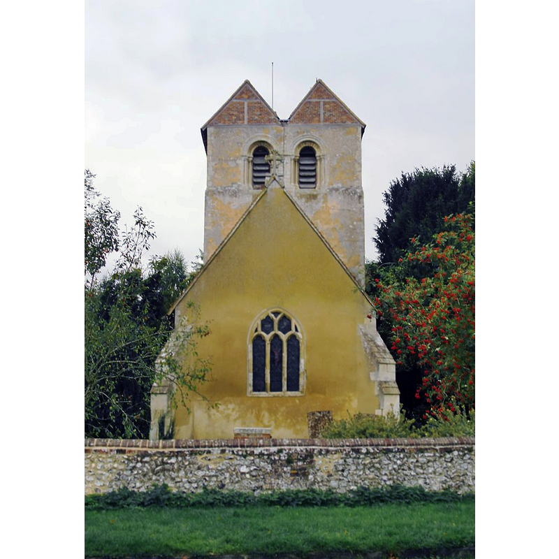
Image copyright © Stefan Czapski, 2013
CC-BY-SA-2.0
Results: 5 records
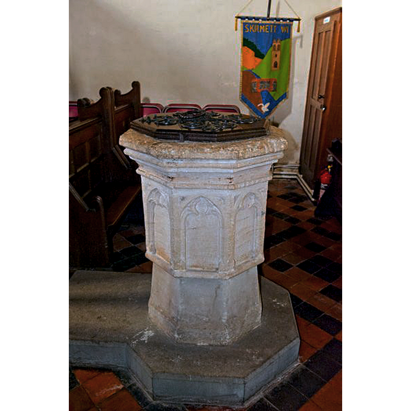
view of font and cover - south side
Copyright Statement: Image copyright © Stefan Czapski, 2013
Image Source: digital photograph taken 8 October 2013 by Stefan Czapski [www.geograph.org.uk/photo/3696398] [accessed 8 October 2015]
Copyright Instructions: CC-BY-SA-2.0
design element - architectural - arcade - blind - trefoiled arches or windows - 8
Scene Description: [cf. Font notes]
Copyright Statement: Image copyright © Stefan Czapski, 2013
Image Source: digital photograph taken 8 October 2013 by Stefan Czapski [www.geograph.org.uk/photo/3696398] [accessed 8 October 2015]
Copyright Instructions: CC-BY-SA-2.0
design element - motifs - moulding - graded
Scene Description: [cf. Font notes]
Copyright Statement: Image copyright © Stefan Czapski, 2013
Image Source: digital photograph taken 8 October 2013 by Stefan Czapski [www.geograph.org.uk/photo/3696398] [accessed 8 October 2015]
Copyright Instructions: CC-BY-SA-2.0
view of church exterior - east view
Scene Description: Source caption: "Fingest church from the east. Much of the church is of Norman origin, in particular the west tower, which Pevsner reckons is 27 feet square at its base - wider than the nave. Nonetheless, the tower's most distinctive feature - its double pitched roof with brick-built gables - is without doubt a much later addition. Pevsner guessed it might date from the 17th century (see the Buckinghamshire volume of 'The Buildings of England') while the Listing Text (compiled in 1955) suggests an 18th or early 19th century date."
Copyright Statement: Image copyright © David Ross & Britain Express Ltd, 2015
Image Source: digital photograph taken by David Ross [www.britainexpress.com/images/attractions/editor/Fingest-8478.jpg] [accessed 8 October 2015]
Copyright Instructions: Standing permission
view of church exterior - southeast view
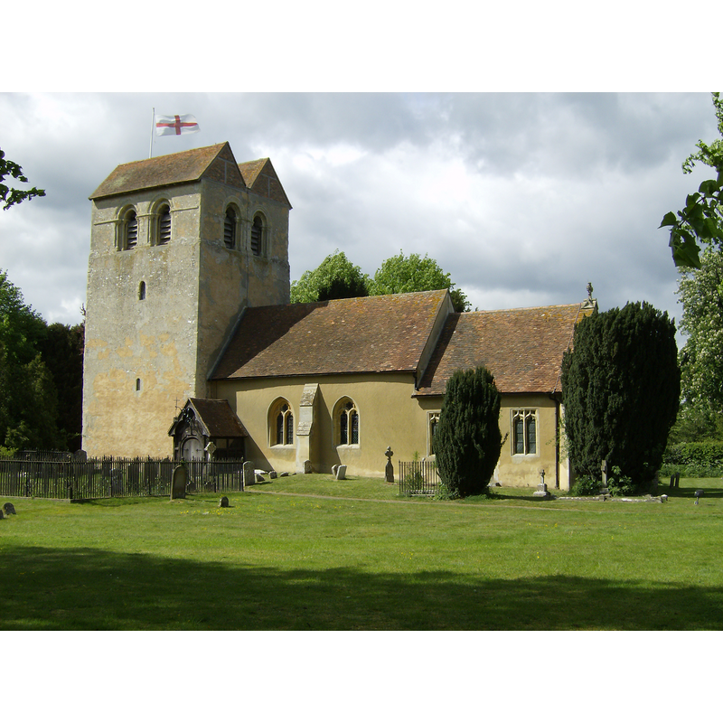
Copyright Statement: Image copyright © [in the public domain]
Image Source: digital photograph taken 6 May 2007 by Sealman [http://en.wikipedia.org/wiki/File:Fingest_Church.JPG]
Copyright Instructions: Released by the author into the public domain
INFORMATION
Font ID: 10588FIN
Object Type: Baptismal Font1
Date Visited: 2008-04-13
Font Century and Period/Style: 15th century [basin only] [composite font], Late Medieval
Church / Chapel Name: Parish Church of St. Bartholomew
Font Location in Church: Inside the church, at the W end, beneath the tower
Church Patron Saint(s): St. Bartholomew
Church Notes: original church probably late-Norman as is the west tower, but the saddle-back top is actually modern, 18th or 19thC?
Church Address: Fingest, Henley-on-Thames, Oxfordshire, RG9 6QE
Site Location: Buckinghamshire, South East, England, United Kingdom
Directions to Site: Located 10 km NNE of Henley-on-Thames 10 WSW of High Wycombe, 12-13 km NW of Marlow
Ecclesiastic Region: Diocese of Oxford
Historical Region: Hundred of Desborough
Additional Comments: visited the font with Nick Hearn [colleague from Oxford Univ - TAY/TABS] and his wife Lena]; did not have a camera with us.
Font Notes:
Click to view
No entry found for Fingest in the Domesday syrvey. Lysons (1806-1833) describe an octagonal baptismal font "enriched with arches", but Lewis' Dictionary of 1848 reports the font, as "circular, and enriched with arches". Sheahan (1862) reports: "The font is octangular". Described in the RCAHM (Buckinghamshire, 1912): "octagonal bowl, with moulded rim, and a trefoiled sunk panel in each side, 15th-century, base and stem, modern." The Victoria County History (Buckingham, vol. 3, 1925) notes that the identification of the entry for 'Dileherst' [Domesday, 1086] as Fingest, which Lipscomb (1831-1843) and other earlier writers suggest, is wrong; the present-day corresponding place is 'Tylers Green', in Burnham Hundred [NB: Fingest was in Desborough Hundred]. The VCH (ibid.) further notes that there is no entry for Fingest Manor in the Domesday Book. The VCH (ibid.) notes the 12th-century tower and nave, and adds: "The panelled octagonal bowl of the font is of the 15th century, but the stem and base are modern." Noted in Pevsner (1960): "Font. Simple, octagonal, C14." On-site notes: two volumes: the basin has graded mouldings around the upper side below which is a blank arcade of pointed arches with trefoiled windows; at the bottom rim of the basin a single thin roll moulding; the pedestal base is broad, octagonal and plain; it is raised on an octagonal plinth with kneeling stone. The basin is lead lined; central drain. [NB: despite the contradictory shape given by Lewis (round) [cf. supra], the Hambleden Valley Churches web site confirms the octagonal shape of this 15th-century font].
Credit and Acknowledgements: We are grateful to David Ross, Britain Express Ltd [www.britainexpress.com], for his photograph of this font
COORDINATES
UTM: 30U 646794 5720208
Latitude & Longitude (Decimal): 51.613742, -0.879804
Latitude & Longitude (DMS): 51° 36′ 49.47″ N, 0° 52′ 47.29″ W
MEDIUM AND MEASUREMENTS
Material: stone
Font Shape: octagonal, mounted
Basin Interior Shape: round
Basin Exterior Shape: octagonal
Drainage System: centre hole in basin
Drainage Notes: lead lining
LID INFORMATION
Date: modern?
Material: wood, oak
Apparatus: no
Notes: octagonal and flat, with metal decoration and ring handle; appears modern; perhaps 19th-century?
REFERENCES
- Victoria County History [online], University of London, 1993-. URL: https://www.british-history.ac.uk.
- Great Britain. Royal Commission on Historical Monuments (England), An inventory of the historical monuments in Buckinghamshire, London: H.M. Stationary Office, 1912-, vol. 1: 157
- Lewis, Samuel, A Topographical Dictionary of England, Comprising the Several Counties, Cities, Boroughs, Corporate and Market Towns, Parishes, Chapelries, and Townships, and the Islands of Guernsy, Jersey, and Man, with Historical and Statistical Descriptions [...], London: S. Lewis, 1831, [www.british-history.ac.uk/report.asp?compid=50963] [accessed 5 February 2007]
- Lysons, Daniel, Magna Britannia, being a concise topographical account of the several counties of Great Britain, London: Printed for T. Cadell and W. Davies, 1806-1822, vol. I: p. 489
- Pevsner, Nikolaus, Buckinghamshire, Harmondsworth: Penguin, 1960, p. 136
- Sheahan, James Joseph, History and topography of Buckinghamshire, comprising a general survey of the county, preceded by an epitome of the early history of Great Britain, London; Pontefract: Longman, Green, Longman, and Roberts; William Edward Bonas [...], 1862, p. 883