Kings Ripton / Kingesrippton / King's Ripton / Rippetona / Riptone / Riptone Regis / Ryptone Regis
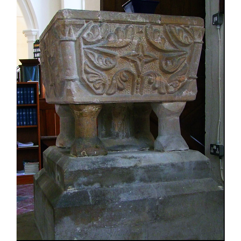
Image copyright © Simon Knott, 2015
Standing permission
Results: 7 records
design element - motifs - foliage
Copyright Statement: Image copyright © Simon Knott, 2015
Image Source: edited detail of a digital photograph 5 July 2-15 by Simon Knott [https://www.flickr.com/photos/norfolkodyssey/19993415365/in/photostream/] [accessed 23 February 2024]
Copyright Instructions: Standing permission
design element - architectural - column - columns with capitals and bases
Copyright Statement: Image copyright © Simon Knott, 2015
Image Source: edited detail of a digital photograph 5 July 2-15 by Simon Knott [https://www.flickr.com/photos/norfolkodyssey/19993415365/in/photostream/] [accessed 23 February 2024]
Copyright Instructions: Standing permission
symbol - star - 4-points
Copyright Statement: Image copyright © Simon Knott, 2015
Image Source: edited detail of a digital photograph 5 July 2-15 by Simon Knott [https://www.flickr.com/photos/norfolkodyssey/19993415365/in/photostream/] [accessed 23 February 2024]
Copyright Instructions: Standing permission
view of church exterior - southeast view
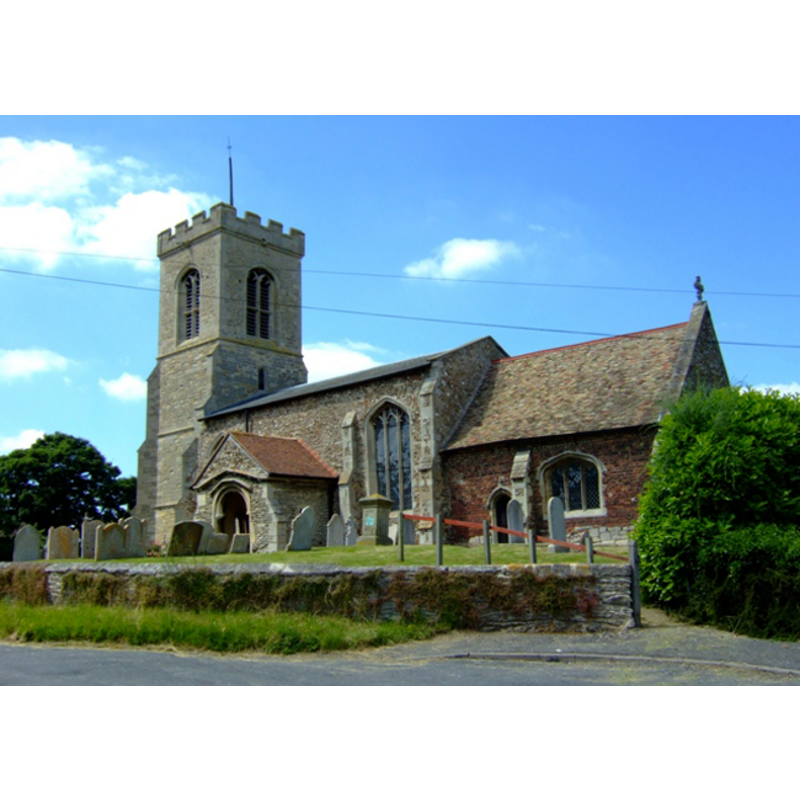
Copyright Statement: Image copyright © Simon Huguet, 2008
Image Source: digital photograph taken 10 June 2008 by Simon Huguet [www.geograph.org.uk/photo/839692] [accessed 23 April 2012]
Copyright Instructions: CC-BY-SA-3.0
design element - architectural - capital - cushion capital
Copyright Statement: Image copyright © Simon Knott, 2015
Image Source: edited detail of a digital photograph 5 July 2-15 by Simon Knott [https://www.flickr.com/photos/norfolkodyssey/19993415365/in/photostream/] [accessed 23 February 2024]
Copyright Instructions: Standing permission
view of font - northeast side

Copyright Statement: Image copyright © Ron Baxter / CRSBI, 2024
Image Source: digital photograph by Ron Baxter in the CRSBI [https://www.crsbi.ac.uk/view-item?i=62357] [accessed 23 February 2024]
Copyright Instructions: PERMISSION NOT AVAILABLE -- IMAGE NOT FOR PUBLIC USE
view of font
Copyright Statement: Image copyright © University of London & History of Parliament Trust, 2011
Image Source: drawing in the VCH [ww.british-history.ac.uk/report.aspx?compid=42485] [accessed 23 April 2012]
Copyright Instructions: PERMISSION NOT AVAILABLE -- IMAGE NOT FOR PUBLIC USE
INFORMATION
Font ID: 10481RIP
Object Type: Baptismal Font1
Font Century and Period/Style: 12th century (late?), Late Norman? / Transitional?
Church / Chapel Name: Parish Church of St. Peter
Font Location in Church: Inside the church
Church Patron Saint(s): St. Peter
Church Address: School Lane, Kings Ripton, Cambridgeshire PE28 2NL, UK
Site Location: Cambridgeshire, East, England, United Kingdom
Directions to Site: Located off the B1090, 6 km NNE of Huntingdon
Ecclesiastic Region: Diocese of Ely
Historical Region: formerly Huntingdonshire -- Hundred of Hurstingstone
Additional Comments: disappeared font? (the font from the 11thC church?)
Font Notes:
Click to view
The Victoria County History (Huntingdon, vol. 2, 1932) notes: "Although not mentioned by name in the Domesday Survey, the church is without doubt one of the two churches recorded under the manor of Hartford. Of this building, however, nothing remains, the earliest part of the present church being the south wall of the nave, probably of the 13th century, and the north and east walls of the chancel dating from late in the same century. [...] The church was restored about 1851. [...] The late 12th-century font has a square bowl ornamented with crude carvings, supported on an octagonal central and four angle shafts, the latter with cushion caps and similar inverted bases." Noted in Pevsner (1968): "Font. Square, with tapering sides. Norman stylized leaves on the sides, including on three sides colonnettes to separate the leaf motifs." The lower base appears modern.
COORDINATES
UTM: 30U 694154 5806295
Latitude & Longitude (Decimal): 52.372469, -0.147824
Latitude & Longitude (DMS): 52° 22′ 20.89″ N, 0° 8′ 52.16″ W
MEDIUM AND MEASUREMENTS
Material: stone
Font Shape: square, mounted
Basin Interior Shape: round
Basin Exterior Shape: square
REFERENCES
- Victoria County History [online], University of London, 1993-. URL: https://www.british-history.ac.uk.
- Pevsner, Nikolaus, Bedfordshire and the County of Huntingdon and Peterborough, Harmondsworth: Penguin, 1968, p. 281-282