Clifton Reynes / Clifton / Clifton next Oineye / Cliftone / Clistone
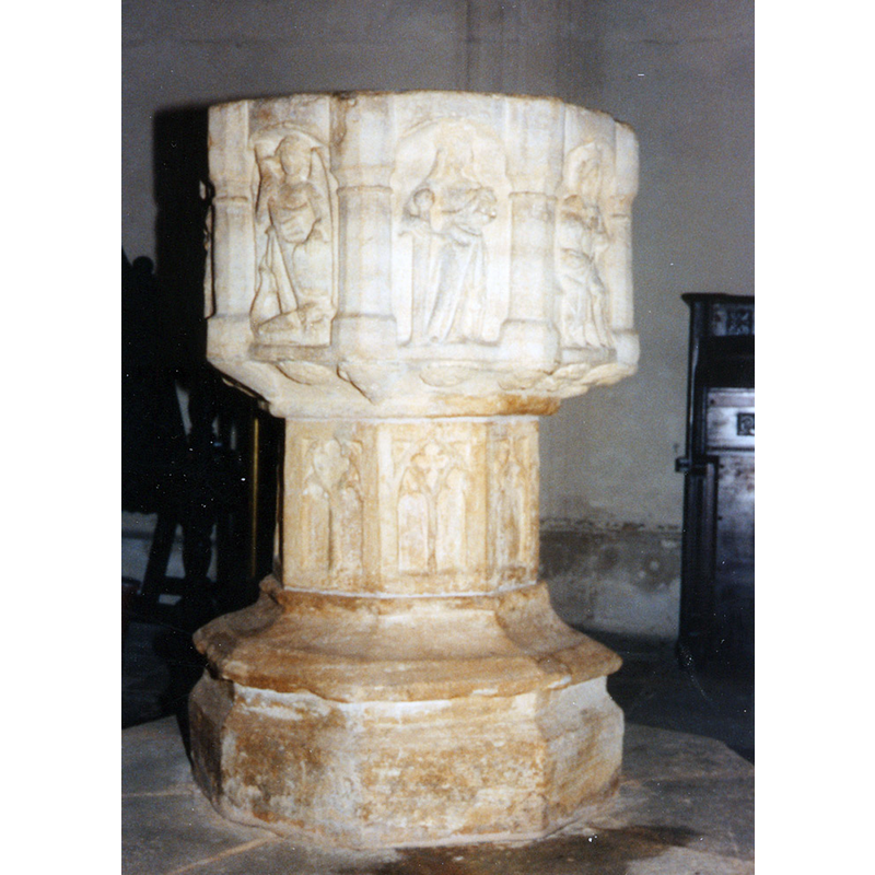
Image copyright © John Salmon, 2012
CC-BY-SA-2.0
Results: 14 records
B01: New Testament - Virgin Mary - Madonna with Christ-child
![on the north side of the basin [cf. FontNotes] [seen here on the right side of the basin](/static-50478a99ec6f36a15d6234548c59f63da52304e5/compressed/1150910016_compressed.png)
Scene Description: on the north side of the basin [cf. FontNotes] [seen here on the right side of the basin
Copyright Statement: Image copyright © John Salmon, 2012
Image Source: detail of a digital photograph taken 19 December 2012 by John Salmon [www.geograph.org.uk/photo/3265609] [accessed 10 September 2015]
Copyright Instructions: CC-BY-SA-2.0
B02: Apostle or saint - St. Catherine of Alexandria
Scene Description: [seen here on the centre side of the basin]
Copyright Statement: Image copyright © John Salmon, 2012
Image Source: detail of a digital photograph taken 19 December 2012 by John Salmon [www.geograph.org.uk/photo/3265609] [accessed 10 September 2015]
Copyright Instructions: CC-BY-SA-2.0
B03: angel - archangel - St. Michael
![on the east side of the basin -- [seen here on the left side of the basin]](/static-50478a99ec6f36a15d6234548c59f63da52304e5/others/image_not_available.jpg)
Scene Description: on the east side of the basin -- [seen here on the left side of the basin]
![on the east side of the basin -- [seen here on the left side of the basin]](/static-50478a99ec6f36a15d6234548c59f63da52304e5/bsi-testing-site/others/image_not_available.jpg)
B04: Apostle or saint - Apostles - St. Peter
B05: God - Trinity
Scene Description: on the south side of the basin [cf. FontNotes]
B06: Apostle or saint - Apostles - St. Paul
B07: Apostle or saint - St. Barbara?
Scene Description: holding a tower? Or, St. Mary Magdalen with her vial of ointment? [cf. FontNotes]
B08: Apostle or saint - St. Margaret of Antioch
view of font
Copyright Statement: Image copyright © John Salmon, 2012
Image Source: digital photograph taken 19 December 2012 by John Salmon [www.geograph.org.uk/photo/3265609] [accessed 10 September 2015]
Copyright Instructions: CC-BY-SA-2.0
design element - architectural - buttress - 8
Copyright Statement: Image copyright © John Salmon, 2012
Image Source: detail of a digital photograph taken 19 December 2012 by John Salmon [www.geograph.org.uk/photo/3265609] [accessed 10 September 2015]
Copyright Instructions: CC-BY-SA-2.0
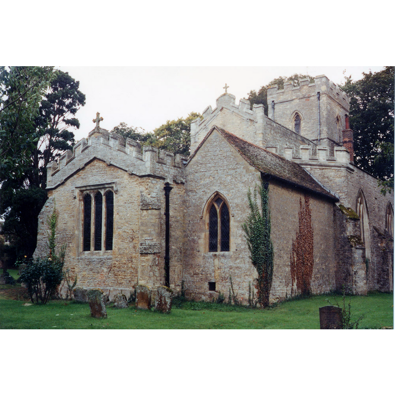
view of church exterior - northeast view
Copyright Statement: Image copyright © John Salmon, 2012
Image Source: digital photograph taken 19 December 2012 by John Salmon [www.geograph.org.uk/photo/3265605] [accessed 10 September 2015]
Copyright Instructions: CC-BY-SA-2.0
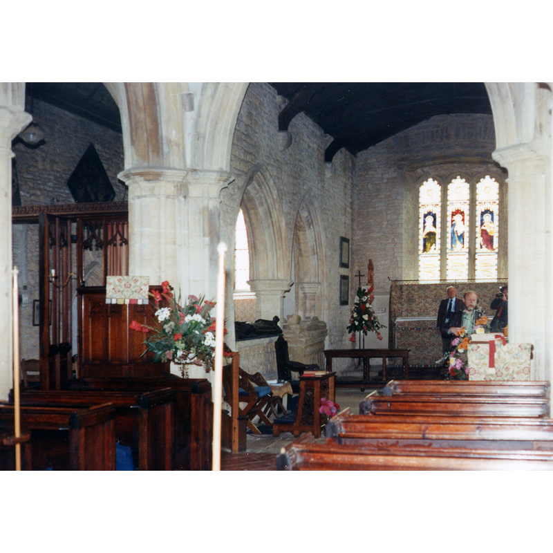
view of church interior - nave - looking east
Copyright Statement: Image copyright © John Salmon, 2012
Image Source: digital photograph taken 19 December 2012 by John Salmon [www.geograph.org.uk/photo/3265607] [accessed 10 September 2015]
Copyright Instructions: CC-BY-SA-2.0
design element - patterns - tracery - window tracery
Copyright Statement: Image copyright © John Salmon, 2012
Image Source: digital photograph taken 19 December 2012 by John Salmon [www.geograph.org.uk/photo/3265609] [accessed 10 September 2015]
Copyright Instructions: CC-BY-SA-2.0
design element - motifs - moulding
Copyright Statement: Image copyright © John Salmon, 2012
Image Source: digital photograph taken 19 December 2012 by John Salmon [www.geograph.org.uk/photo/3265609] [accessed 10 September 2015]
Copyright Instructions: CC-BY-SA-2.0
INFORMATION
Font ID: 10312CLI
Object Type: Baptismal Font1
Font Date: ca. 1350?
Font Century and Period/Style: 14th century (mid?), Decorated
Cognate Fonts: The font at Sherington / Sherrington, in the same county
Church / Chapel Name: Parish Church of St. Mary
Font Location in Church: Inside the church, at the W end of the S aisle
Church Patron Saint(s): St. Mary the Virgin
Church Notes: original church here 12thC [cf. FontNotes]
Church Address: Church Lane, Clifton Reynes, Milton Keynes MK46 5DT
Site Location: Buckinghamshire, South East, England, United Kingdom
Directions to Site: Located 2 km E of Olney, 8 km NNW of Newport Pagnell, in the northeast-most corner of the county
Ecclesiastic Region: Diocese of Oxford
Historical Region: Houndred of Moulsoe [in Domesday]
Additional Comments: disappeared font? (the one from the original 12thC church here)
Font Notes:
Click to view
There are five entries for Clifton [Reynes] [variant spelling] in the Domesday survey [http://opendomesday.org/place/SP9051/clifton-reynes/] [accessed 10 September 2015], none of which mentions cleric or church in it. Lysons (1806-1833) describe an octagonal baptismal font "enriched with figures in niches". Lewis' Dictionary of 1848 mentions simply "an ancient font" in this church. Sheahan (1862) describes the church as "an interesting structure, supposed to have been built about the time of King Edward I" [i.e., 1272-1307], "repaired at a considerable expense" in 1842-1843; "The octagonal font is very fine, having each side ornamented wih the effigy of a saint, in bold relief, under a Gothic canopy." The Victoria County History (Buckingham, vol. 4, 1927) finds an earlier fabric in the church tower: "The lower stage of the tower is the only remaining portion of a 12th-century church [...] the existing aisles were added in the 13th century [...] The font is a fine example of late 14th-century work. The bowl is octagonal and has a small shaft at each angle, from each pair of which springs a segmental arch forming a niche which contains a figure. In the niche on the north face are figures of the Virgin and Child, with St. Margaret and St. Katherine in the niches on either side, and on the south is the Trinity, with St. Peter and St. Paul in the flanking niches. In the east and west niches are St. Michael and St. Mary Magdalene or, more likely, St. Barbara, as the object held in the hands resembles a tower rather than the box of ointment. The lower edge of the bowl is enriched with heads and foliage, and each face of the octagonal stem, which stands on a moulded base, has a traceried panel." Pevsner (1960) notes: "Font. C14. Octagonal, with figures of the Virgin, the Trinity, and Saints." The wooden cover is an octagonal pyramid with open-work traceried panels; floral finial; appears modern.
COORDINATES
UTM: 30U 658207 5780641
Latitude & Longitude (Decimal): 52.153573, -0.687395
Latitude & Longitude (DMS): 52° 9′ 12.86″ N, 0° 41′ 14.62″ W
MEDIUM AND MEASUREMENTS
Material: stone
Font Shape: octagonal, mounted
Basin Interior Shape: round
Basin Exterior Shape: octagonal
Drainage Notes: lead-lined
LID INFORMATION
Material: wood, oak
Apparatus: yes; chain and pulley
REFERENCES
- Victoria County History [online], University of London, 1993-. URL: https://www.british-history.ac.uk.
- Lewis, Samuel, A Topographical Dictionary of England, Comprising the Several Counties, Cities, Boroughs, Corporate and Market Towns, Parishes, Chapelries, and Townships, and the Islands of Guernsy, Jersey, and Man, with Historical and Statistical Descriptions [...], London: S. Lewis, 1831, [www.british-history.ec.uk/report.asp?compid=50884] [accessed 24 January 2007]
- Lysons, Daniel, Magna Britannia, being a concise topographical account of the several counties of Great Britain, London: Printed for T. Cadell and W. Davies, 1806-1822, vol. I: p. 489
- Pevsner, Nikolaus, Buckinghamshire, Harmondsworth: Penguin, 1960, p. 97
- Sheahan, James Joseph, History and topography of Buckinghamshire, comprising a general survey of the county, preceded by an epitome of the early history of Great Britain, London; Pontefract: Longman, Green, Longman, and Roberts; William Edward Bonas [...], 1862, p. 521