Bridgham No. 2
Results: 1 records
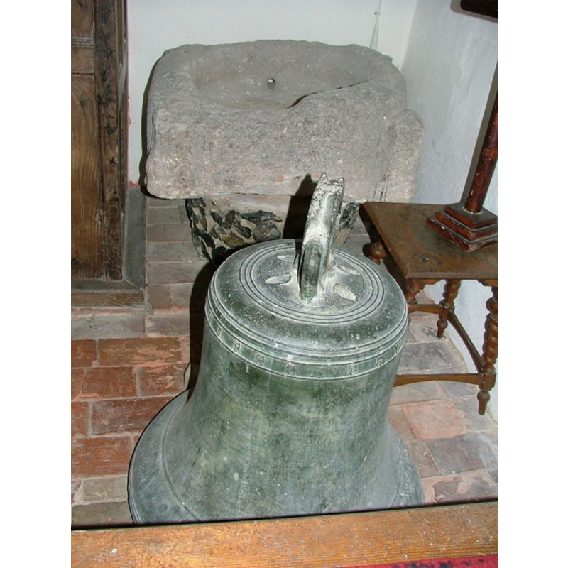
view of basin - fragment
INFORMATION
Font ID: 10158BRI
Object Type: Baptismal Font1, fragment
Font Century and Period/Style: 12th century, Late Norman
Church / Chapel Name: Parish Church of St. Mary the Virgin [originally from the parish church at Roudham]
Font Location in Church: Now [2004] in the church at Bridgham
Church Patron Saint(s): St. Mary the Virgin
Church Address: The Street, Bridgham, Norfolk, NR16 2RY
Site Location: Norfolk, East Anglia, England, United Kingdom
Directions to Site: Brigham is located off the A11, near Roudham, 10-12 km ENE of Thetford
Ecclesiastic Region: Diocese of Norwich
Historical Region: Hundred of Shropham
Additional Comments: recycled font: originally from Roudham -- disappeared font? (the one from the original church here)
Font Notes:
Click to view
Blomefield (1805-1810) describes the church here: "The Church hath its nave, north porch, and chancel, thatched; it hath no steeple, but there are two bells, which hang in a house in the churchyard. In the windows", and its first reported chaplain/rector, "Robert de Wynewyk", in 1303, but does not mention the original font here. One of two fonts noted in Pevsner & Wilson (1999) in this church: "Norman font from Roudham, tub-shaped with angle spurs." The Historic Churches Preservation Trust mentions a "Noman bowl" originally from the church at Roudham [source: 'Recent Grants' issue of the Grants Cttee. Meeting of 22 June 2004, www.historicchurches.org.uk]. Knott (2006) writes: "The bell from the tower now sits on the nave floor at Bridgham, along with a font which is very weathered and may well also have been brought from here." The fragment reported by Simon Knott [cf. supra] at Bridgham Church appears to be the lower half of a medieval basin that was originally square at the bottom and rounded at the top with colonnettes at 90-degree angles; there appears to have been carving on the sides and on the colonnettes themselves, but the piece is too worn and damaged to make anything of its surface. There is a hole drilled on the side, near the bottom of the well, which is probably an indication of its use as a farm or garden trough; the basin would have originally had a central drain, most likely].
Credit and Acknowledgements: We are grateful to Simon Knott, of www.norfolkchurches.co.uk, for his photographs of this font
COORDINATES
UTM: 31U 355763 5811562
Latitude & Longitude (Decimal): 52.435201, 0.878202
Latitude & Longitude (DMS): 52° 26′ 6.73″ N, 0° 52′ 41.53″ E
MEDIUM AND MEASUREMENTS
Material: stone
Font Shape: round-to-square, mounted
Basin Interior Shape: round
Basin Exterior Shape: round-to-square
Drainage System: [cf. FontNotes]
Drainage Notes: [cf. FontNotes]
REFERENCES
- Blomefield, Francis, An essay towards a topographical history of Norfolk, 1805-1810, vol. 1: 436-440 / [www.british-history.ac.uk/report.aspx?compid=77131] [accessed 27 February 2013]
- Knott, Simon, The Norfolk Churches Site, Simon Knott, 2004. [standing permission to reproduce images received from Simon (February 2005]. URL: www.norfolkchurches.co.uk.
- Pevsner, Nikolaus, Norfolk 2: North-West and South (2nd ed.), London: Penguin, 1999, p. 218