Gamlingay / Gamelinge / Gamelingei
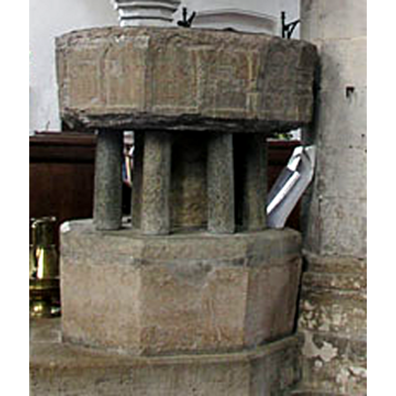
Image copyright © Mark Ynis-Mon, 2004
Standing permission
Results: 7 records
view of font
Copyright Statement: Image copyright © Mark Ynis-Mon, 2004
Image Source: detail of a digital photograph by Mark Ynys-Mon, 2004 [http://www.druidic.org/camchurch/churches/gamlingay.htm] [accessed 26 October 2007]
Copyright Instructions: Standing permission
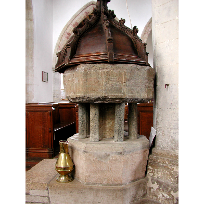
view of font and cover

Copyright Statement: Image copyright © Mark Ynis-Mon, 2004
Image Source: digital photograph by Mark Ynys-Mon, 2004 [http://www.druidic.org/camchurch/churches/gamlingay.htm] [accessed 26 October 2007]
Copyright Instructions: Standing permission
view of font
Copyright Statement: Image copyright © Colin Hinson, 2008
Image Source: digital photograph 2008 by Colin Hinson [www.yorkshireCDbooks.coml]
Copyright Instructions: Standing permission
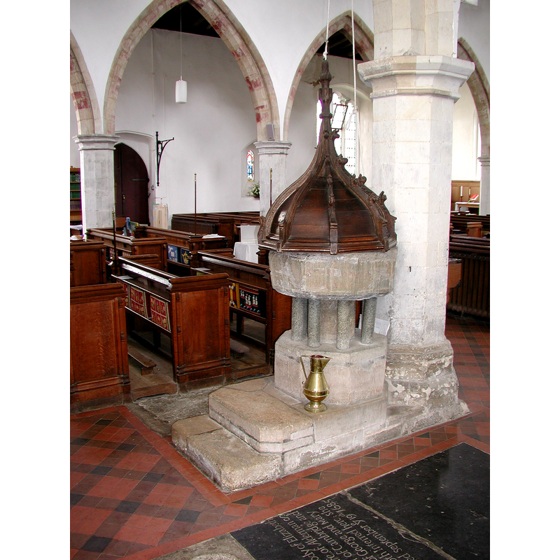
view of font and cover in context
Copyright Statement: Image copyright © Colin Hinson, 2008
Image Source: digital photograph 2008 by Colin Hinson [www.yorkshireCDbooks.coml]
Copyright Instructions: Standing permission
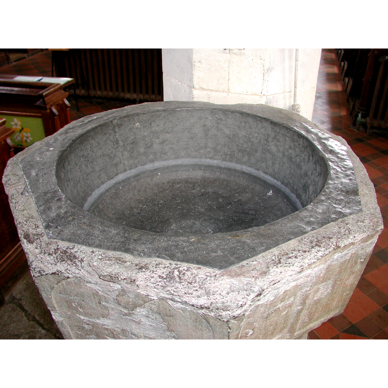
view of basin's top
Copyright Statement: Image copyright © Colin Hinson, 2008
Image Source: digital photograph 2008 by Colin Hinson [www.yorkshireCDbooks.coml]
Copyright Instructions: Standing permission
design element - architectural - arcade - Gothic arches - 16
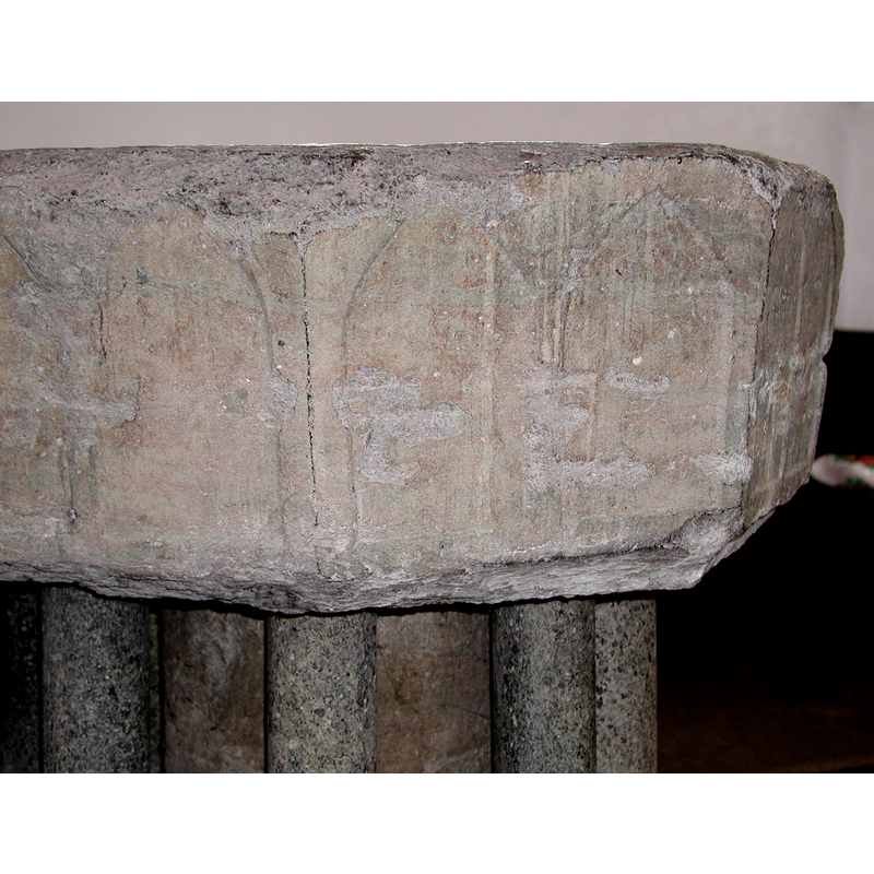
Scene Description: two per panel
Copyright Statement: Image copyright © Colin Hinson, 2008
Image Source: digital photograph 2008 by Colin Hinson [www.yorkshireCDbooks.coml]
Copyright Instructions: Standing permission
view of church exterior - northwest view
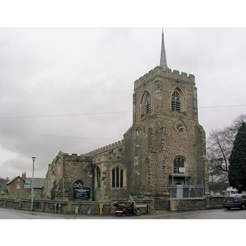
Copyright Statement: Image copyright © Mark Ynis-Mon, 2004
Image Source: digital photograph by Mark Ynys-Mon, 2004 [http://www.druidic.org/camchurch/churches/gamlingay.htm] [accessed 26 October 2007]
Copyright Instructions: Permission received (standing permission)
INFORMATION
Font ID: 10064GAM
Object Type: Baptismal Font1
Font Date: ca. 1200?
Font Century and Period/Style: 12th - 13th century, Transitional / Early English
Church / Chapel Name: Parish Church of St. Mary the Virgin
Font Location in Church: Inside the church, in the S nave, near a pillar of the W end
Church Patron Saint(s): St. Mary the Virgin
Church Address: Church St, Gamlingay, Cambridgeshire SG19 3JH, United Kingdom
Site Location: Cambridgeshire, East, England, United Kingdom
Directions to Site: Located on the B1040, about 10 km SE of St. Neots, 25 km WSW of Cambridge
Ecclesiastic Region: Diocese of Ely
Historical Region: Hundred of Longstowe
Additional Comments: damaged font: the basin is in a very poor shape -- two fonts? The RCHM suggests the lower base may be the basin of another font -- disappeared font? (the one from the early 12thC (?) church here)
Font Notes:
Click to view
There are three entries for Gamlingay [variant spelling] in the Domesday survey [http://opendomesday.org/place/TL2452/gamlingay/] [accessed 12 May 2016], none of which mentions cleric or church in it. The RCHM (1968) dates the "limestone marble" basin to the 13th century and notes: "sub-base conciveably incorporates the bowl of another font", and suggests a 16th-century date for the restored cover. Described in Pevsner (1970): "Font. Octagonal, of limestone, c.1200, each side with two shallow blank pointed arches, a type usual in many parts of the country, e.g. in Essex." The CRSBI (2016) agrees with Pevsner's dating but remarks that this object "is clearly a variant of the Sussex marble fonts found in that county [Essex] and exported widely, but adds: "Pevsner describes the bowl as limestone, but it may be Purbeck [NB: "Purbeck marble" stone is a variety of limestone]. The Victoria County History (Cambridge..., vol. 5, 1973) notes: "A church existed at Gamlingay before 1120 [...] The existing building does not show any evidence for the form of the church before 1200, but the 13th century was a period of considerable building activity"; there is no mention of a font in the VCH entry. Described and illustrated in the Cambridgeshire Churches web site : "at the west end, against the final pillar of the south arcade, is the 13th century font. It has quite a shallow octagonal bowl, with paired blind arches on each face, and sits on a big central pillar surrounded with eight little shafts. It has a modern cover in the form of a big Tudor-style dome. There is a pulley mechanism to lift it". Baptismal font probably of the Transitional or Early English period; it consists of an octagonal basin with slightly tapering sides decorated with a blind arcade of pointed arches, two per panel; it is raised on a later columnar base consisting of a broad shaft with eight slender colonnettes, and a plain octagonal tapering lower base and a rectangular two-step plinth. The basin is in an appalling state, with the upper and lower rims totally eroded. The round inner well is lead-lined, with a recent lining. Dome wooden font cover, of octagonal shape with crocketed arrises and vegetal finial attached to pulley apparatus. The RCHM (Cambridgeshire, 1968) reports a holy-water stoup "on the S[outh] of the W[est] door", but does indicate a date for it. The Friends of St. Mary's web site notes [http://gamlingaychurch.co.uk/history]: "The font within the church appears to be formed from two font basins. Prior to the works of 1880 there were two fonts, one in the present position and one in the centre aisle. The present font cover was repaired and re-hung in its original position. It is likely that the font basin now in use is in its original position. The basin to the other font has been used as the base for the present construction with 19thc. centre shaft and surrounding shafts supporting the present basin. Both fonts are of early English form, the base font may well have been that of the earliest church on this site". Noted in Leach (1975) as a font made of Purbeck marble: "bowl with two pointed panels on each face" [source given: Pevsner's Cambridgeshire, 1954].
Credit and Acknowledgements: We are grateful to Colin Hinson, of www.genuki.org, and to Ben Colburn and Mark Ynis-Mon, of Cambridgeshire Churches [www.druidic.org/camchurch/], for the information on and photographs of church and font.
COORDINATES
UTM: 30U 692399 5782013
Latitude & Longitude (Decimal): 52.155041, -0.187416
Latitude & Longitude (DMS): 52° 9′ 18.15″ N, 0° 11′ 14.7″ W
MEDIUM AND MEASUREMENTS
Material: stone, limestone [Purbeck marble]
Font Shape: octagonal, mounted
Basin Interior Shape: round
Basin Exterior Shape: octagonal
Drainage System: centre hole in basin
Drainage Notes: lead lining
Rim Thickness: 11 cm [calculated]
Diameter (inside rim): 58 cm*
Diameter (includes rim): 80 cm*
Basin Total Height: 31 cm*
Height of Base: 35 cm [calculated]
Height of Central Column: 29.5 cm [calculated]
Font Height (less Plinth): 66 cm*
Font Height (with Plinth): 93 cm*
Notes on Measurements: * CRSBI (2008)
LID INFORMATION
Date: 16th-century? [restored]
Material: wood
Apparatus: yes; pulley
Notes: [cf. FontNotes]
REFERENCES
- Victoria County History [online], University of London, 1993-. URL: https://www.british-history.ac.uk.
- Corpus of Romanesque Sculpture in Britain and Ireland, The Corpus of Romanesque Sculpture in Britain and Ireland, The Corpus of Romanesque Sculpture in Britain and Ireland. URL: http://www.crsbi.ac.uk.
- Great Britain. Royal Commission on Historical Monuments (England), An inventory of historical monuments in the County of Cambridge, Woking; London: Printed in England for Her Majesty's Stationary Office by Unwin Brothers Unlimited, 1968, vol. 1: xlv, 102
- Leach, Rosemary, A Investigation into the use of Purbeck Marble in Medieval England, Hartlepool: E.W. Harrisons & Sons, 1975, p. 71
- Pevsner, Nikolaus, Cambridgeshire, Harmonsworth: Penguin, 1970, p. 391