Arborfield / Edburgefeld / Erbelgiresfeld / Erburgefeld / Hereburgefeld
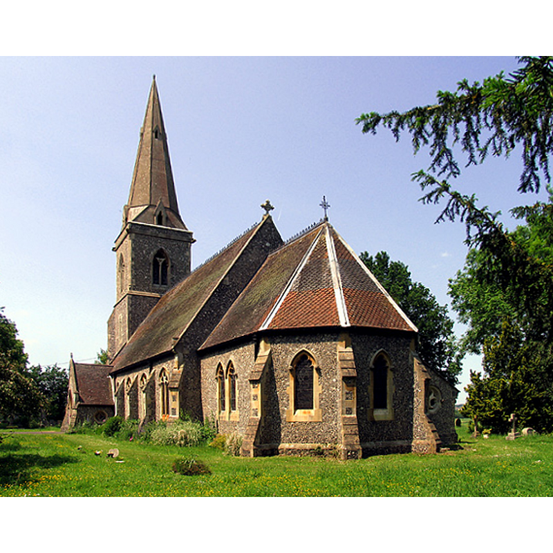
Image copyright © Pam Brophy, 2005
CC-BY-SA-2.0
Results: 3 records
view of church exterior - southeast view
Scene Description: the 19th-century church of St. Batholomew, Arborfield
Copyright Statement: Image copyright © Pam Brophy, 2005
Image Source: digital photograph taken 7 June 2005 by Pam Brophy [www.geograph.org.uk/photo/17640] [accessed 25 March 2015]
Copyright Instructions: CC-BY-SA-2.0
view of church exterior
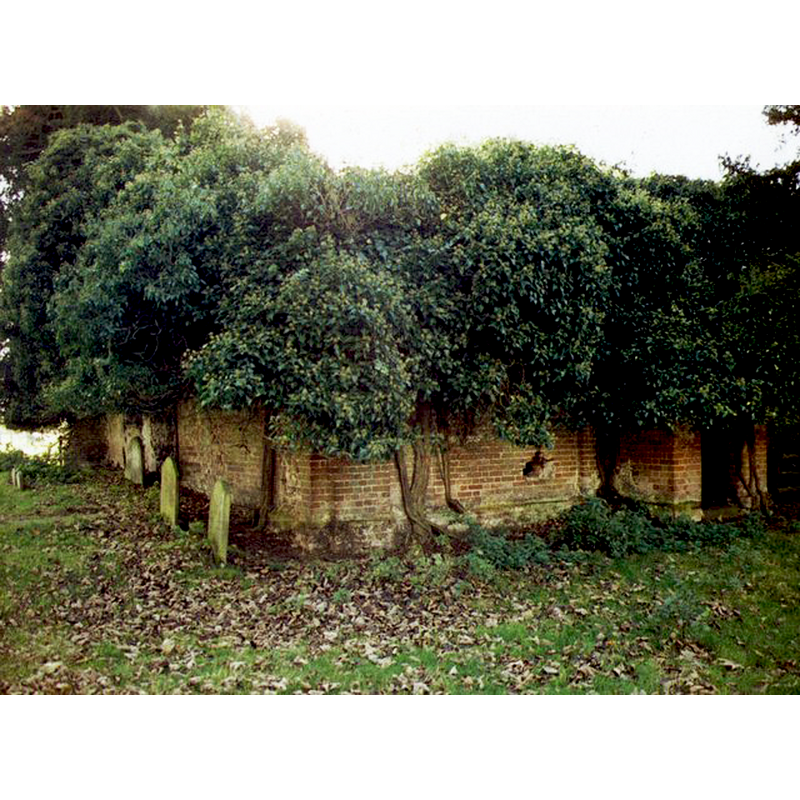
Scene Description: Source caption: "Remains of the Old Church of St Bartholomew, Arborfield. Grade 2 listed building erected in the 13th century."
Copyright Statement: Image copyright © Michael Ford, 2002
Image Source: digital photograph taken in 2002 by Michael Ford [www.geograph.org.uk/photo/1525287] [accessed 25 March 2015]
Copyright Instructions: CC-BY-SA-2.0
view of church exterior
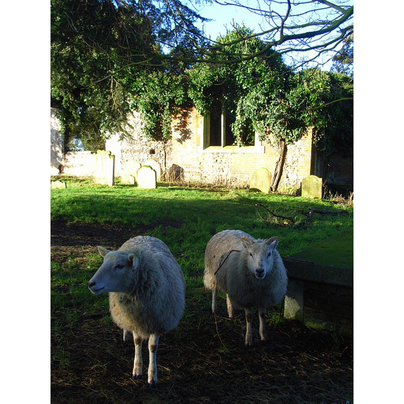
Scene Description: Source caption: "Church ruins, Arborfield. The old church of St Bartholomew's which was abandoned in 1863 in favour of the new edifice dedicated to the same saint."
Copyright Statement: Image copyright © Andrew Smith, 2008
Image Source: digital photograph taken 16 January 2008 by Andrew Smith [www.geograph.org.uk/photo/664414] [accessed 25 March 2015]
Copyright Instructions: CC-BY-SA-2.0
INFORMATION
Font ID: 09989ARB
Object Type: Baptismal Font1
Font Century and Period/Style: 13th century, Medieval
Church / Chapel Name: Parish Church of St. Bartholomew [the new church]
Font Location in Church: Inside the new church [cf. FontNotes]
Church Patron Saint(s): St. Bartholomew
Church Notes: medieval church abandoned in 1863; in ruins
Church Address: [new church address] Church Lane, Arborfield, Berkshire, RG2 9HZ -- [old church coordinates: 51° 24′ 22.2″ N, 0° 55′ 23.26″ W, 51.406167, -0.923126 -- UTM: 30U 644450 5697040]
Site Location: Berkshire, South East, England, United Kingdom
Directions to Site: Located on the A327, 7 km SE of Reading
Ecclesiastic Region: Diocese of Oxford
Historical Region: Hundred of Sonning
Font Notes:
Click to view
No entry for Arborfield found in the Domesday survey. The Victoria County History (Berkshire, vol. 3, 1923) notes: "The church of Arborfield was originally a chapel of Sonning [...] about 1190 [...] The church of St. Bartholomew is a small building erected in 1863, [...] The old church, also dedicated in honour of St. Bartholomew, stood on the west of the present one near Arborfield Hall. Owing to its bad state of repair the roof was taken off in 1863, and the bare ruined walls alone remain. [...] The old font, which is of wood, is preserved at the hall." "Lovely old wooden font [...] from an older St. Bartholomew's Church" [source: http://genealogy.rootsweb,com/~villages/berks/arborfirld.htm]. "Near to the site of Arborfield House, once the seat of the Standen family, stands the ruins of a 13th century church, which used to contain a rare type of font carved from a solid block of wood with an oak cover. This font, together with a stained glass window, has been removed to the present parish church" [source: www.chardnet.free-online.co.uk/berkshireattractions.html] [accessed 26 June 2007]. The wooden font is reported in a visitation by Archdeacon Randall on Monday, 8 October 1855: "The church in a very bad condition. The roof apparently in a state of decay. Directed it to be examined by opening it in several places. The font, a wooden one, but lined with lead and a pewter basin within. Directed the basin to be disused and a drain made." [source: www.arborfieldhistory.org.uk/church_old.htm [accessed 25 November 2011]]. This same wooden font is reported undergoing repairs again in 1948: "The Wooden Font from the Old Church was being repaired for new use", and, a year later. In 1949, "In the new church, the old Stone Font was to be left in place even though the Wooden Font would be used instead." [source: Minute Book of Arborfield Parochial Church Council covering the period from 1935 to 1954 [www.arborfieldhistory.org.uk/church_new_PCC_1935.htm] [accessed 25 November 2011]].
COORDINATES
UTM: 30U 645256 5696818
Latitude & Longitude (Decimal): 51.403966, -0.911648
Latitude & Longitude (DMS): 51° 24′ 14.28″ N, 0° 54′ 41.93″ W
MEDIUM AND MEASUREMENTS
Material: wood
REFERENCES
- Victoria County History [online], University of London, 1993-. URL: https://www.british-history.ac.uk.