Rivington / Rawinton / Revington / Revyngton / Riuiton / Rouynton / Rovington / Rowinton / Rowynton / Roynton / Ruhwinton / Ryvington
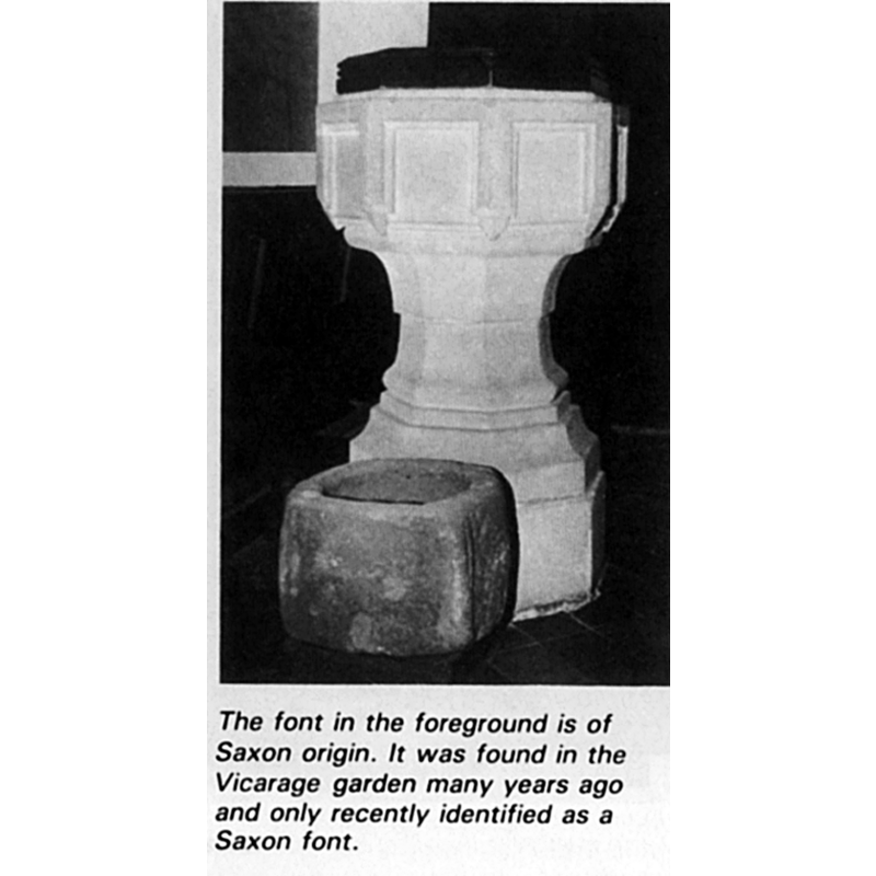
Image copyright © Rivington Parish Church, 2010
No known copyright restriction / Fair Dealing
Results: 2 records
view of font
Scene Description: the two fonts (?) side by side
Copyright Statement: Image copyright © Rivington Parish Church, 2010
Image Source: digital image of a B&W photograph [origin unknown] in the Parish website [http://www.rivington-lancashire.com/index2Page3.html] [accessed 11 May 2010
Copyright Instructions: No known copyright restriction / Fair Dealing
view of church exterior - southeast view
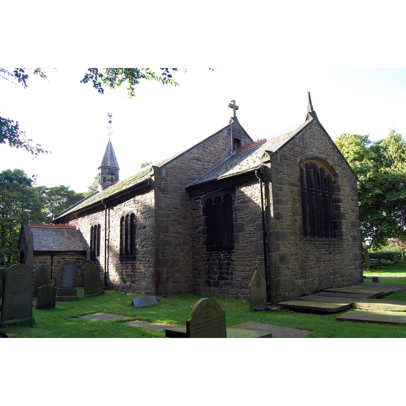
Copyright Statement: Image copyright © J3Mrs, 2010
Image Source: digital photograph taken 30 August 2010 by J3Mrs [https://commons.wikimedia.org/wiki/File:Rivington_Church.JPG] [accessed 11 March 2019]
Copyright Instructions: GFDL / CC-BY-SA-2.0
INFORMATION
Font ID: 09966RIV
Object Type: Baptismal Font1?
Font Century and Period/Style: 10th - 15th century, Medieval
Church / Chapel Name: Rivington Church [aka Parish Church of the Holy Trinity]
Font Location in Church: Inside the church [cf. FontNotes]
Church Patron Saint(s): The Holy Trinity [and various other dedications]
Church Notes: present church consecrated 1541 built on the site of an earlier church
Church Address: Rivington, Bolton, UK
Site Location: Greater Manchester, North West, England, United Kingdom
Directions to Site: Located off (E) the M61, across the reservoir, 3 km N of Horwich, 11 km NW of Bolton
Ecclesiastic Region: Diocese of Manchester
Historical Region: formerly Lancashire
Font Notes:
Click to view
No individual entry found for Rivington in the Domesday survey. Lewis' Dictionary of 1848 notes that, although an inscription dates this chapel to ca. 1530, the pulpit, chancel screen and font "are thought to be of much higher antiquity." The entry for this township in the Victoria County History (Lancaster, vol. 5, 1911) notes: "A chapel of ease was built at Rivington some time before the Reformation, [...] and was rebuilt or restored by Richard Pilkington about 1540 [...] The present structure structure appears to be a rebuilding, about 1666, of the 16th-century chapel of Richard Pilkington"; no font mentioned. The Rivington Parish website notes and illustrates two fonts (?): "The font, which was originally at the West End, was refixed in its present position in 1883. Tragically the conical oak cover has been disposed of." The font referred to in this text is octagonal, with panel decoration on the sides, and mouldings on its base; it is probably 19th-century, unless it is a re-cut of a late-Medieval font; the second font (?) is a crude small basin squarish but with rounded sides and totally plain; is it a font at all?: "a Saxon Font, found in the locality, and given to the Rev. G.E.Owen by Charles Sixsmith of Anderton, and which is now housed in the Millennium Room at the Church."
COORDINATES
UTM: 30U 528545 5941909
Latitude & Longitude (Decimal): 53.6252, -2.5684
Latitude & Longitude (DMS): 53° 37′ 30.72″ N, 2° 34′ 6.24″ W
MEDIUM AND MEASUREMENTS
Material: stone
Font Shape: square
Basin Interior Shape: round
Basin Exterior Shape: square
REFERENCES
- Victoria County History [online], University of London, 1993-. URL: https://www.british-history.ac.uk.
- Lewis, Samuel, A Topographical Dictionary of England, Comprising the Several Counties, Cities, Boroughs, Corporate and Market Towns, Parishes, Chapelries, and Townships, and the Islands of Guernsy, Jersey, and Man, with Historical and Statistical Descriptions [...], London: S. Lewis, 1831, [www.british-history.ac.uk/report.asp?compid=51240] [accessed 26 February 2007]