Horton nr. Leek / Horten / Hortene / Hortone
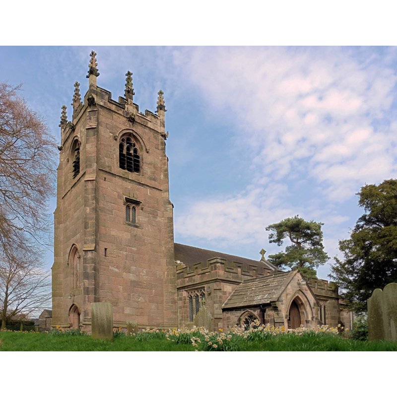
Image copyright © Dave Kelly, 2018
CC-BY-SA-2.0
Results: 1 records
view of church exterior - southwest view
Copyright Statement: Image copyright © Dave Kelly, 2018
Image Source: edited detail of a digital photograph taken 12 April 2018 by Dave Kelly [www.geograph.org.uk/photo/5916238] [accessed 30 July 2019]
Copyright Instructions: CC-BY-SA-2.0
INFORMATION
Font ID: 09834HOR
Object Type: Baptismal Font1
Font Century and Period/Style: 15th century, Perpendicular
Church / Chapel Name: Parish Church of St. Michael and All Angels
Font Location in Church: [cf. FontNotes]
Church Patron Saint(s): St. Michael & All Angels
Church Address: Horton, Stoke-on-Trent ST13 8RX, UK -- Tel.: 07930 277370
Site Location: Staffordshire, West Midlands, England, United Kingdom
Directions to Site: Located off (W) the A523, N of the A53, 6 km WNW of Leek, 15-20 km NNE of Stoke-on-Trent
Ecclesiastic Region: Diocese of Lichfield
Historical Region: Hundred of Offlow
Additional Comments: disappeared font? (the 15thC font noted in the early sources must have been replaced by the present 19thC font; no information available on the whereabouts of the old one)
Font Notes:
Click to view
There is an entry for this Horton [variant spelling] in the Domesday survey [https://opendomesday.org/place/SK1709/horton/] [accessed 30 July 2019] but it mentions neither cleric nor church in it. The entry for this parish in the Victoria County History (Stafford, vol. 7, 1996) notes: "A chapel at Horton was probably one of the dependent chapels granted with Leek church to Dieulacres abbey in the early 1220s. It was mentioned by name in Bishop Stavensby's confirmation of the grant between 1224 and 1228. [...] Horton was described as a parish in the earlier 1530s, [...] although in 1535 the church was recorded with others as a chapel of Leek and the grant of Leek rectory to Sir Ralph Bagnall in 1560 included what was described as Horton chapel. [...] The church of ST. MICHAEL, so called by 1480, [...] is built of sandstone and consists of a chancel, an aisled nave of three bays, a southwest porch, and a west tower. [...] The tower and the north aisle date from the 15th century, having been added to an earlier nave, none of whose fabric survives. [...] The font dates from the 15th century" [NB: the font mentioned in the VCH entry is footnoted to "T.B.A.S. lxviii. 21.", the date of which would be in the 1940s; was the old font still in place then?] Described as a plain octagonal basin raised on steps in an entry in the index of the William Salt Library, Stafford [www.staffordshire.gov.uk/live/pdf/archives/fis-lei.pdf] lists under reference SV IV.351b for a sepia drawing of 1844 by John Buckler. The drawing (8 in. x 7 in.) illustrates an octagonal font, probably of the same Perpendicular style as the other parts of the building. Not mentioned in Pevsner's Staffordshire (1975 c1974). The entry for this church in Historic England [Listing NGR: SJ9421557377] notes: "Parish church. C15 with C17 alterations and largely internal circa 1864 restoration [...] C19 octagonal stone font of drum shape with coved rim. " [NB: was the font replaced in the 1864 restoration?]
COORDINATES
UTM: 30U 561070 5885309
Latitude & Longitude (Decimal): 53.11371, -2.0876
Latitude & Longitude (DMS): 53° 6′ 49.36″ N, 2° 5′ 15.36″ W
MEDIUM AND MEASUREMENTS
Material: stone
Font Shape: octagonal, mounted
Basin Exterior Shape: octagonal
REFERENCES
- Victoria County History [online], University of London, 1993-. URL: https://www.british-history.ac.uk.