Netherbury / Niderberie
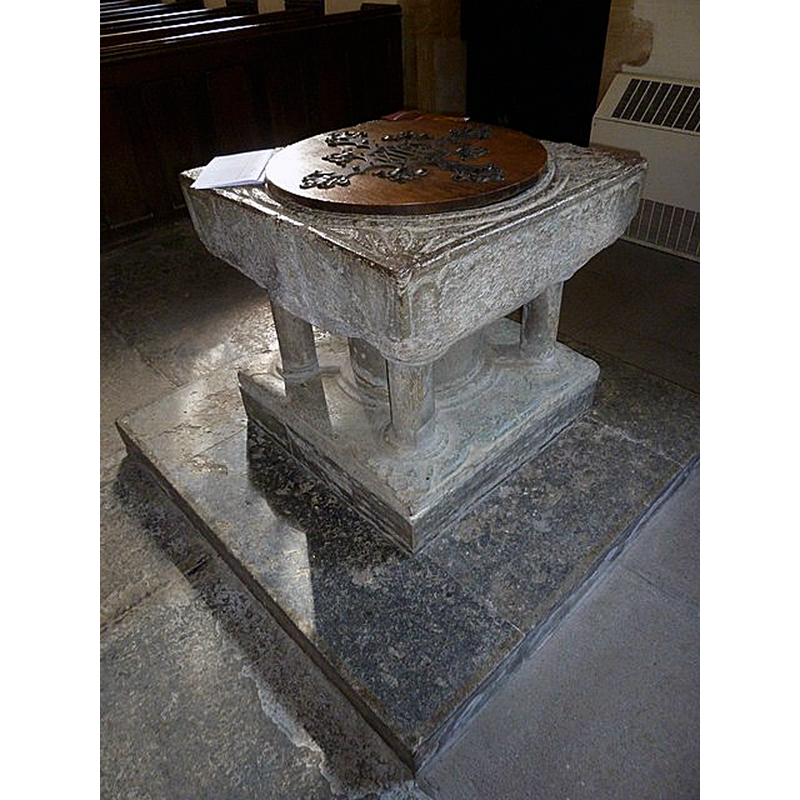
Image copyright © Basher Eyre, 2013
CC-BY-SA-2.5
Results: 9 records
view of font and cover
Scene Description: Source caption: "St. Mary, Netherbury: font"
Copyright Statement: Image copyright © Basher Eyre, 2013
Image Source: digital photograph 4 September 2013 by Basher Eyre [https://www.geograph.org.uk/photo/3919393] [accessed 14 February 2023]
Copyright Instructions: CC-BY-SA-2.5
view of font and cover
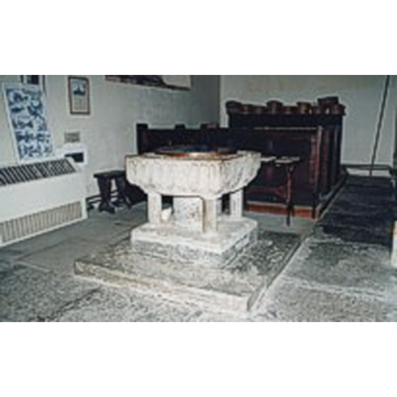
Copyright Statement: Image copyright © The Dorset Historic Churches Trust, 2005
Image Source: digital image in The Dorset Historic Churches Trust, 2005 [http://dorsethistoricchurchestrust.co.uk]
Copyright Instructions: Standing permission
design element - architectural - arcade - blind - round arches
Copyright Statement: Image copyright © Basher Eyre, 2013
Image Source: digital photograph 4 September 2013 by Basher Eyre [https://www.geograph.org.uk/photo/3919393] [accessed 14 February 2023]
Copyright Instructions: CC-BY-SA-2.5
design element - motifs - floral - 4
Scene Description: in the spandrels of the upper rim corners
Copyright Statement: Image copyright © Basher Eyre, 2013
Image Source: digital photograph 4 September 2013 by Basher Eyre [https://www.geograph.org.uk/photo/3919393] [accessed 14 February 2023]
Copyright Instructions: CC-BY-SA-2.5
design element - motifs - moulding
Scene Description: around the opening of the basin interior
Copyright Statement: Image copyright © Basher Eyre, 2013
Image Source: digital photograph 4 September 2013 by Basher Eyre [https://www.geograph.org.uk/photo/3919393] [accessed 14 February 2023]
Copyright Instructions: CC-BY-SA-2.5
view of church exterior - south view
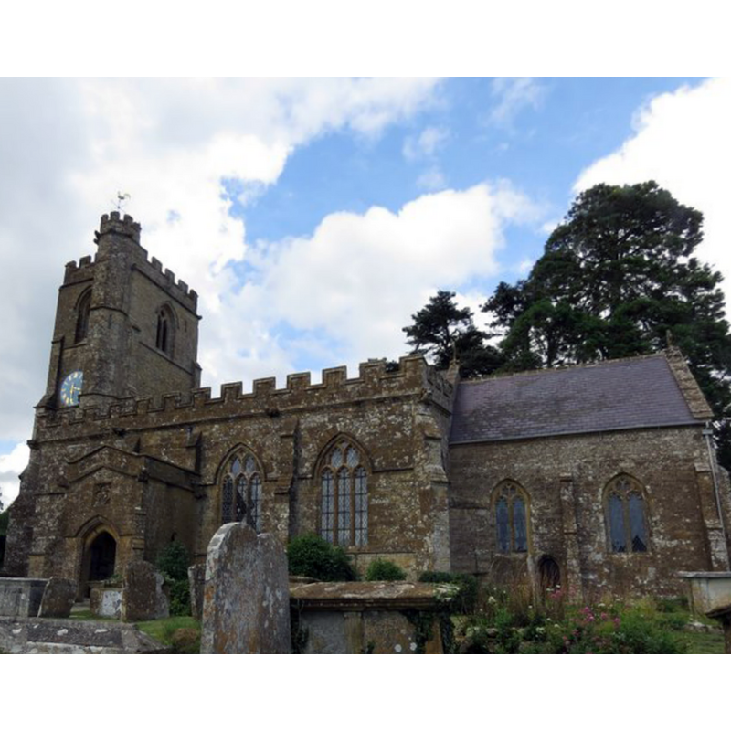
Scene Description: Source caption: "St Mary's Church, Netherbury"
Copyright Statement: Image copyright © Becky Williamson, 2016
Image Source: digital photograph 5 August 2016 by Becky Williamson [https://www.geograph.org.uk/photo/5070801] [accessed 14 February 2023]
Copyright Instructions: CC-BY-SA-2.5
view of church exterior - north view
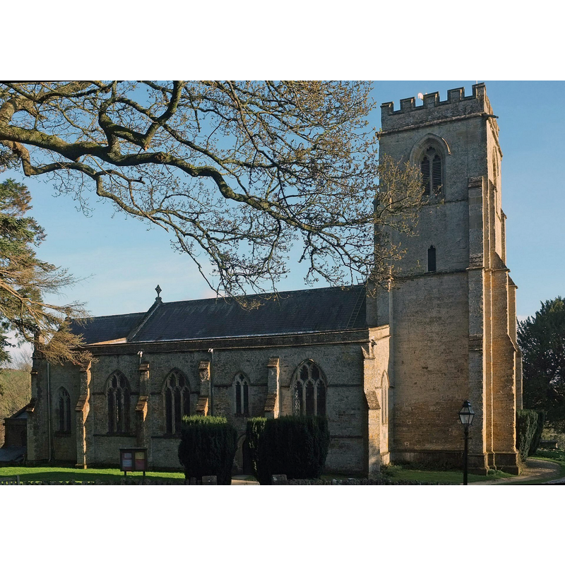
Scene Description: Source caption: "St Mary's Church, Netherbury. From Tower Hill."
Copyright Statement: Image copyright © Derek Harper, 2016
Image Source: digital photograph 12 April 2016 by Derek Harper [https://www.geograph.org.uk/photo/4914003] [accessed 14 February 2023]
Copyright Instructions: CC-BY-SA-2.5
design element - motifs - moulding - 4
Scene Description: on the bases of the central shaft and four outer colonnettes
Copyright Statement: Image copyright © Basher Eyre, 2013
Image Source: digital photograph 4 September 2013 by Basher Eyre [https://www.geograph.org.uk/photo/3919393] [accessed 14 February 2023]
Copyright Instructions: CC-BY-SA-2.5
design element - motifs - zigzag


INFORMATION
Font ID: 09358NET
Object Type: Baptismal Font1
Font Century and Period/Style: 12th century (late?), Norman? / Transitional?
Church / Chapel Name: Parish Church of St. Mary the Virgin
Font Location in Church: Inside the church
Church Patron Saint(s): St. Mary the Virgin
Church Address: Tower Hill, Netherbury, Bridport DT6 5LR, United Kingdom -- Tel.: +44 1308 862320
Site Location: Dorset, South West, England, United Kingdom
Directions to Site: Located off (W) the A3066, 2 km S of Beaminster, about 10 km N of Bridport
Ecclesiastic Region: Diocese of Salisbury
Historical Region: Hundred of Beaminster
Additional Comments: famous person font: Admiral Sir Samuel Hood (1724-1816) baptised in it
Font Notes:
Click to view
There is an entry for Netherbury [variant spelling] in the Domesday survey [https://opendomesday.org/place/SY4799/netherbury/] [accessed 14 February 2023]; it mentions neither cleric nor church in it. Noted in Long (1923) and in Mee (1939) as a baptismal font of the Norman period. In Newman & Pevsner (1972): "Font. Square, of Purbeck marble, very shallow in height. Against the sides two short blank arches, also zigzag. All badly preserved. Leaves in the spandrels of the top surface. Norman." The Dorset Historic Churches Trust [http://dorsethistoricchurchestrust.co.uk/netherbury.htm] notes: "shallow Norman font where Admiral Sir Samuel Hood (1724-1816) [...] was christened". The entry for this church in Historic England [Listing NGR: SY4703099464] notes: "Parish Church, C14 nave and aisles, with C14/15 chancel, C15 west tower. South porch rebuilt in 1848 [...] Font, Purbeck marble, square bowl with arched panels and simple foliage spanrels on top. Central, and four subsidiary shafts with moulded capping and base, late C12." Noted in Leach (1975) as a font made of Purbeck marble: "bowl with panels or chevron patterns on faces" [source given: RCHM (W), 1952].
Credit and Acknowledgements: We are grateful to Robin Adeney and The Dorset Historic Churches Trust [www.dorsethistoricchurchestrust.co.uk], for the photograph of this font
COORDINATES
UTM: 30U 517419 5626754
Latitude & Longitude (Decimal): 50.792274, -2.752855
Latitude & Longitude (DMS): 50° 47′ 32.18″ N, 2° 45′ 10.28″ W
MEDIUM AND MEASUREMENTS
Material: stone, limestone (Purbeck marble)
Font Shape: square, mounted
Basin Interior Shape: round
Basin Exterior Shape: square
LID INFORMATION
Date: modern
Material: wood
Apparatus: no
Notes: round and flat, with metal decoration and handle; modern
REFERENCES
- Leach, Rosemary, A Investigation into the use of Purbeck Marble in Medieval England, Hartlepool: E.W. Harrisons & Sons, 1975, p. 72
- Long, E.T., "Dorset church fonts", 44, Proceedings of the Dorset Natural History and Antiquarian Field Club, 1923, pp. 62-76; p. 75
- Mee, Arthur, The King's England. Dorset: Thomas Hardy's Country, London: Hodder & Stoughton, 1939, p. 168
- Pevsner, Nikolaus, Dorset, Harmondsworth: Penguin, 1972, p. 303