Westbury nr. Trowbridge / Wesberie / Westberie / Westbury-under-the-Plain

Image copyright © Basher Eyre, 2016
CC-BY-SA-2.0
Results: 8 records
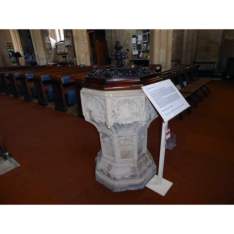
view of font and cover
Copyright Statement: Image copyright © Basher Eyre, 2016
Image Source: edited detail of a digital photograph taken 22 August 2016 by Basher Eyre [www.geograph.org.uk/photo/5089093] [accessed 12 February 2019]
Copyright Instructions: CC-BY-SA-2.0
symbol - shield - 8
Scene Description: the shields are carved in an awkward position, catching the bend of the underbowl chamfer
Copyright Statement: Image copyright © Basher Eyre, 2016
Image Source: edited detail of a digital photograph taken 22 August 2016 by Basher Eyre [www.geograph.org.uk/photo/5089093] [accessed 12 February 2019]
Copyright Instructions: CC-BY-SA-2.0
design element - motifs - panel - trefoiled - 8
Copyright Statement: Image copyright © Basher Eyre, 2016
Image Source: edited detail of a digital photograph taken 22 August 2016 by Basher Eyre [www.geograph.org.uk/photo/5089093] [accessed 12 February 2019]
Copyright Instructions: CC-BY-SA-2.0
view of church exterior - southeast view
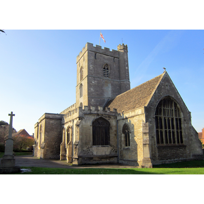
Copyright Statement: Image copyright © My another account, 2011
Image Source: digital photograph taken 13 November 2011 by My another account [http://en.wikipedia.org/wiki/File:All_Saints%27_Westbury.JPG] [accessed 24 February 2012]
Copyright Instructions: CC-BY-SA-2.0
view of font and cover in context
Scene Description: the font at the west end of the nave
Copyright Statement: Image copyright © Basher Eyre, 2016
Image Source: digital photograph taken 22 August 2016 by Basher Eyre [www.geograph.org.uk/photo/5089093] [accessed 12 February 2019]
Copyright Instructions: CC-BY-SA-2.0
view of church interior - nave - looking west
![the font is visile at the far [west] end of the centre aisle](/static-50478a99ec6f36a15d6234548c59f63da52304e5/compressed/1190212012_compressed.png)
Scene Description: the font is visile at the far [west] end of the centre aisle
Copyright Statement: Image copyright © Basher Eyre, 2016
Image Source: digital photograph taken 22 August 2016 by Basher Eyre [www.geograph.org.uk/photo/5089084] [accessed 12 February 2019]
Copyright Instructions: CC-BY-SA-2.0
design element - architectural - arch or window - trefoiled - 8
Copyright Statement: Image copyright © Basher Eyre, 2016
Image Source: edited detail of a digital photograph taken 22 August 2016 by Basher Eyre [www.geograph.org.uk/photo/5089093] [accessed 12 February 2019]
Copyright Instructions: CC-BY-SA-2.0
design element - motifs - moulding - graded
Copyright Statement: Image copyright © Basher Eyre, 2016
Image Source: edited detail of a digital photograph taken 22 August 2016 by Basher Eyre [www.geograph.org.uk/photo/5089093] [accessed 12 February 2019]
Copyright Instructions: CC-BY-SA-2.0
INFORMATION
Font ID: 09331WES
Object Type: Baptismal Font1
Font Century and Period/Style: 15th century, Perpendicular
Workshop/Group/Artisan: heraldic font
Church / Chapel Name: Parish Church of All Saints
Font Location in Church: Inside the church, in the Penleigh chapel -- Confirmed inside the church ca. 2000
Church Patron Saint(s): All Saints
Church Address: 39 Church St, Westbury, Wiltshire BA13 3DA, UK -- Tel.: +44 1373 859450
Site Location: Wiltshire, South West, England, United Kingdom
Directions to Site: Located 7 km SSE of Trowbridge, 30 km SE of Bath
Ecclesiastic Region: Diocese of Salisbury
Historical Region: Hundred of Westbury
Additional Comments: disappeared font? (the one from the Domesday-time church here)
Font Notes:
Click to view
There are two entries for this Westbury [variant spellings] in the Domesday survey [https://opendomesday.org/place/ST8751/westbury/] [accessed 12 February 2019] one of which reports a priest, a church and "1.5 church lands" in it. The entry for this parish in the Victoria County History (Wiltshire, vol. 8, 1965) notes: "The church of Westbury is mentioned in 1086 [...] The church was worth 50s. in 1086. [...] In 1291 the value was £40. [...] All the surviving features of the church are in the Perpendicular style and suggest that there was an extensive re-building in the 15th century. [...] Extensive restoration was undertaken in 1847 [...] The font [...] dates from the 15th century." It is located in the Penleigh chapel, formerly the Westbury chapel, in the north aisle. Noted in Pevsner & Cherry (1975): "Font. Octagonal, Perp[endicular], with panelling and shields.
COORDINATES
UTM: 30U 557050 5679260
Latitude & Longitude (Decimal): 51.261835, -2.182352
Latitude & Longitude (DMS): 51° 15′ 42.61″ N, 2° 10′ 56.47″ W
MEDIUM AND MEASUREMENTS
Material: stone
Font Shape: octagonal, mounted
Basin Interior Shape: round
Basin Exterior Shape: octagonal
LID INFORMATION
Date: modern
Material: wood, oak?
Apparatus: no
Notes: octagonal, with a carved top and finial; modern
REFERENCES
- Victoria County History [online], University of London, 1993-. URL: https://www.british-history.ac.uk.
- Cox, John Charles, Nottinghamshire, London: Allen, 1912, p. 560