Hinton Waldrist / Heenton / Heinton / Henton at Duxford / Hentone / Hinton / Hinton Waldridge / Hinton Walrushe
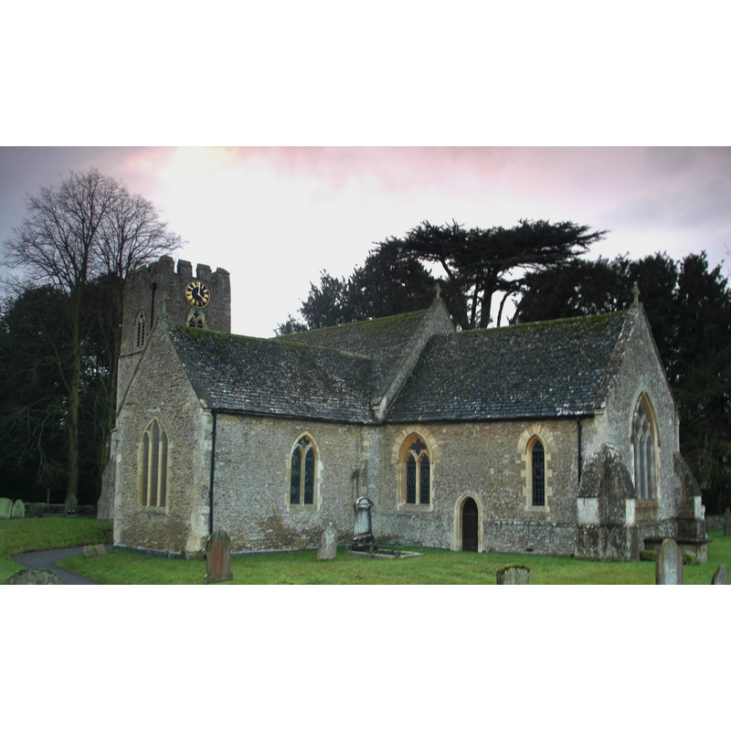
Image copyright © Motacilla, 2011
CC-BY-SA-3.0
Results: 2 records
view of church exterior - southeast view
Copyright Statement: Image copyright © Motacilla, 2011
Image Source: digital photograph taken 17 January 2011 by Motacilla [http://en.wikipedia.org/wiki/Hinton_Waldrist] [accessed 22 November 2011]
Copyright Instructions: CC-BY-SA-3.0
view of font

Scene Description: the modern font
Copyright Statement: Image copyright © Rex Harris, 2013
Image Source: digital photograph taken 20 May 2013 by Rex Harris [www.flickr.com/photos/sheepdog_rex/8728659670/in/photostream/] [accessed 4 June 2015]
Copyright Instructions: PERMISSION NOT AVAILABLE -- IMAGE NOT FOR PUBLIC USE
INFORMATION
Font ID: 08812HIN
Object Type: Stoup
Font Century and Period/Style: 13th - 14th century, Medieval
Church / Chapel Name: Parish Church of St. Margaret of Antioch
Font Location in Church: Ouside the church, on the E side of the S doorway
Church Patron Saint(s): St. Margaret of Antioch [aka Margaret the Virgin, Marina]
Church Address: Church Road, Hinton Waldrist, Oxfordshire, SN7 8SA
Site Location: Oxfordshire, South East, England, United Kingdom
Directions to Site: Located between Faringdon and Oxford, 15 km SW of Oxford
Ecclesiastic Region: Diocese of Oxford
Historical Region: formerly in Berkshire -- Hundred of Ganfield
Additional Comments: disappeared font? (the one from the Domesday-time church here)
Font Notes:
Click to view
There are two entries for Hinton [Waldrist] [variant spelling] in the Domesday survey [http://opendomesday.org/place/SU3899/hinton-waldrist/] [accessed 4 June 2015], one of which mentions a church in it. A stoup of the Decorated period here is noted in Parker (1850). Listed in Cox & Harvey (1907) as a holy-water stoup of the 14th century "at Hinton, Berks." The Victoria County History (Berkshire, vol. 4, 1924) notes: "There was a church in the parish at the time of the Domesday Survey. [...] The nave, chancel and tower all apparently formed part of a church built about 1250 [...] plain pointed south doorway, probably of the 13th century, and having to the east of it, externally, a stoup set high in the wall with a square stone head." The present font in this church is modern, late-19th century (?) of Decorated style design. [NB: we have no information on the font from the Domesday-time church here].
COORDINATES
UTM: 30U 606524 5727619
Latitude & Longitude (Decimal): 51.689409, -1.458915
Latitude & Longitude (DMS): 51° 41′ 21.87″ N, 1° 27′ 32.09″ W
MEDIUM AND MEASUREMENTS
Material: stone
REFERENCES
- Victoria County History [online], University of London, 1993-. URL: https://www.british-history.ac.uk.
- Cox, John Charles, English Church Furniture, New York: E.P. Dutton & Co., 1907, p. 236
- Parker, John Henry, A Glossary of Terms used in Grecian, Roman, Italian and Gothic Architecture, Oxford: J. H. Parker, 1850, p. 448