Harlton / Herletone
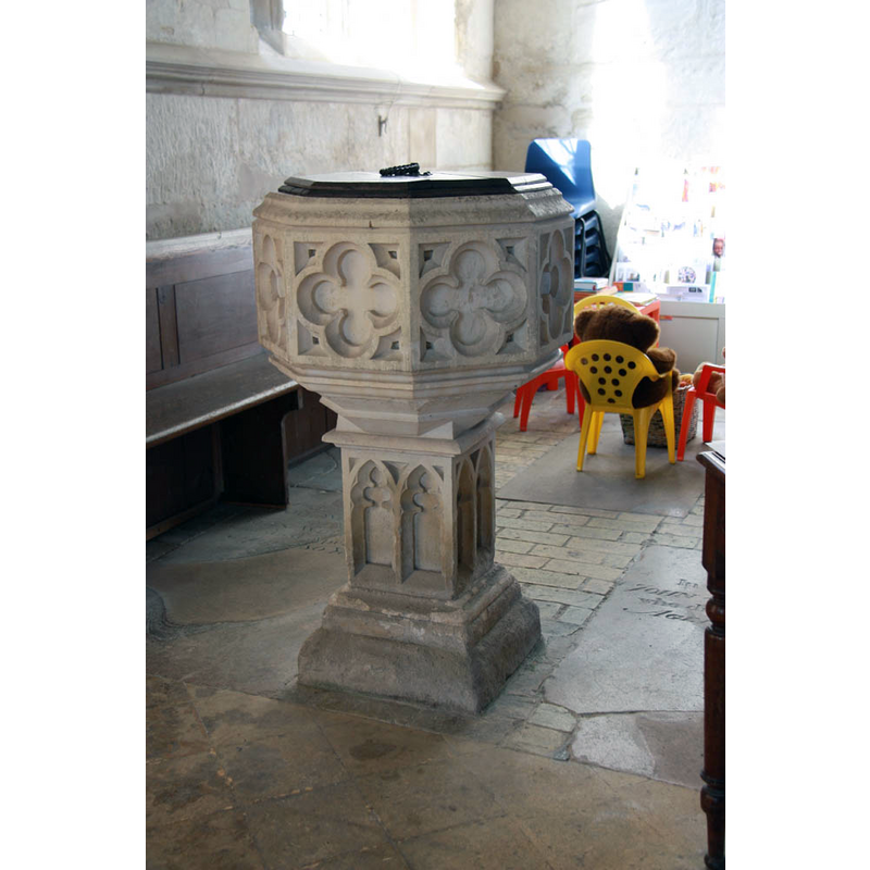
Image copyright © John Salmon, 2012
CC-BY-SA-2.0
Results: 5 records
view of font and cover
Scene Description: the modern font
Copyright Statement: Image copyright © John Salmon, 2012
Image Source: digital photograph taken 8 September 2012 by John Salmon [www.geograph.org.uk/photo/3149082] [accessed 16 May 2016]
Copyright Instructions: CC-BY-SA-2.0
design element - patterns - ribbed
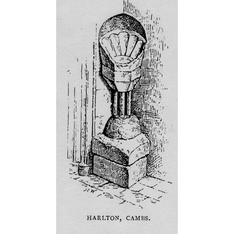
Copyright Statement: Image copyright © [in the public domain]
Image Source: digital image of a drwaing in Cox & Harvey (1907: 236)
Copyright Instructions: PD
view of church exterior - southeast view
![EXT SE digital photograph taken 8 September 2012 by John Salmon [www.geograph.org.uk/photo/3149064] [accessed 16 May 2016]
INT E digital photograph taken 8 September 2012 by John Salmon [www.geograph.org.uk/photo/3149065] [accessed 16 May 2016]
MOD FONT digital photograph taken 8 September 2012 by John Salmon [www.geograph.org.uk/photo/3149082] [accessed 16 May 2016]](/static-50478a99ec6f36a15d6234548c59f63da52304e5/compressed/1160521039_compressed.png)
Scene Description: EXT SE digital photograph taken 8 September 2012 by John Salmon [www.geograph.org.uk/photo/3149064] [accessed 16 May 2016]
INT E digital photograph taken 8 September 2012 by John Salmon [www.geograph.org.uk/photo/3149065] [accessed 16 May 2016]
MOD FONT digital photograph taken 8 September 2012 by John Salmon [www.geograph.org.uk/photo/3149082] [accessed 16 May 2016]
Copyright Statement: Image copyright © John Salmon, 2012
Image Source: digital photograph taken 8 September 2012 by John Salmon [www.geograph.org.uk/photo/3149064] [accessed 16 May 2016]
Copyright Instructions: CC-BY-SA-2.0
view of church interior - nave - looking east

Copyright Statement: Image copyright © John Salmon, 2012
Image Source: digital photograph taken 8 September 2012 by John Salmon [www.geograph.org.uk/photo/3149065] [accessed 16 May 2016]
Copyright Instructions: CC-BY-SA-2.0
view of stoup
Copyright Statement: Image copyright © [in the public domain]
Image Source: digital image of a drwaing in Cox & Harvey (1907: 236)
Copyright Instructions: PD
INFORMATION
Font ID: 08810HAR
Object Type: Stoup
Font Century and Period/Style: 13th - 14th century, Early English? / Decorated?
Church / Chapel Name: Parish Church of the Assumption of the Blessed Virgin Mary
Font Location in Church: In the SW angle of the N porch
Church Patron Saint(s): The Assumption of St. Mary
Church Address: Coach Dr, Harlton, Cambridgeshire CB23 1EY
Site Location: Cambridgeshire, East, England, United Kingdom
Directions to Site: Located on the A10, 11-12 km SW of Cambridge
Ecclesiastic Region: Diocese of Ely
Historical Region: Hundred of Wetherley
Additional Comments: disappeared font? (the one from 11thC church here)
Font Notes:
Click to view
There are two entries for Harlton [variant spelling] in the Domesday survey [http://opendomesday.org/place/TL3852/harlton/] [accessed 16 May 2016], neither of which mentions cleric or church in it. A stoup of the Decorated period is noted in Parker (1850). Holy-water stoup described and illustrated in Cox & Harvey (1907): a "most uncommon example of the same period [i.e., the early 13th century] is to be seen in the porch of Harlton St. Mary, Cambs." The illustration shows what looks like a unique composite of parts: the basin is outwardly polygonal (hexagonal or octagonal probably) whereas the inside shows a concave-rib pattern; the sides of the basin are vertical, those of the underbowl are chamfered, both plain; the stem of the base is columnar, with three detached colonnettes visible and resting on a hemispherical volume; below the latter are two other volumes, both quadrangular, the upper surface of the top one slightly rounded. [NB: a late baptismal font, not listed in this Index, is illustrated in the RCHM (Camdridgeshire, 1968), some of its comments cited in Pevsner (1970): "The Perp[endicular] font is C19. It replaced a font described by the Camden Society as an 'absurd pagan vase'". -- there is no mention of the stoup in Pevsner]. Paley's Guide (1844), which does not mention the stoup, describes the newer font as "a vase, of non-descript style". The Victoria County History (Cambridge..., vol. 5, 1973) notes: "Although Harlton church was not recorded in 1086 it has been suggested that before that date Walter Giffard gave it with the tithe of the demesne and one tenant to the priory of St. Faith at Longueville (Seine Maritime) [...] Certainly Walter or his son Walter had done so by c. 1155, when the gift of Harlton church was confirmed. [...] The whole of the medieval church is the product of a complete rebuilding which took place in the later 14th century. [...] In 1843–4 the church was restored; [...] the Cambridge Camden Society was responsible for the design of the font".
[NB: the RCHM (1968) suggests the fabric of the church goes to the second half of the 14th century, but we have no information on the font of that period]
[NB: the RCHM (1968) suggests the fabric of the church goes to the second half of the 14th century, but we have no information on the font of that period]
COORDINATES
UTM: 31U 296543 5782168
Latitude & Longitude (Decimal): 52.15247, 0.0259
Latitude & Longitude (DMS): 52° 9′ 8.89″ N, 0° 1′ 33.24″ E
MEDIUM AND MEASUREMENTS
Material: stone
Number of Pieces: six?
Font Shape: polygonal, mounted
Basin Interior Shape: round
Basin Exterior Shape: polygonal
REFERENCES
- Victoria County History [online], University of London, 1993-. URL: https://www.british-history.ac.uk.
- Cox, John Charles, English Church Furniture, New York: E.P. Dutton & Co., 1907, p. 236
- Great Britain. Royal Commission on Historical Monuments (England), An inventory of historical monuments in the County of Cambridge, Woking; London: Printed in England for Her Majesty's Stationary Office by Unwin Brothers Unlimited, 1968, vol. 1: xlii and pl. 93;130, 134
- Paley, Frederick Apthorp, The Ecclesiologist's guide to the churches within a circuit of seven miles round Cambridge, with introductory remarks, London; Cambridge: J. van Voorst; Metcalfe and Palmer, 1844, p. 25