Angoustrine / Angostrina / Angoustrine-Villeneuve-des-Escaldes
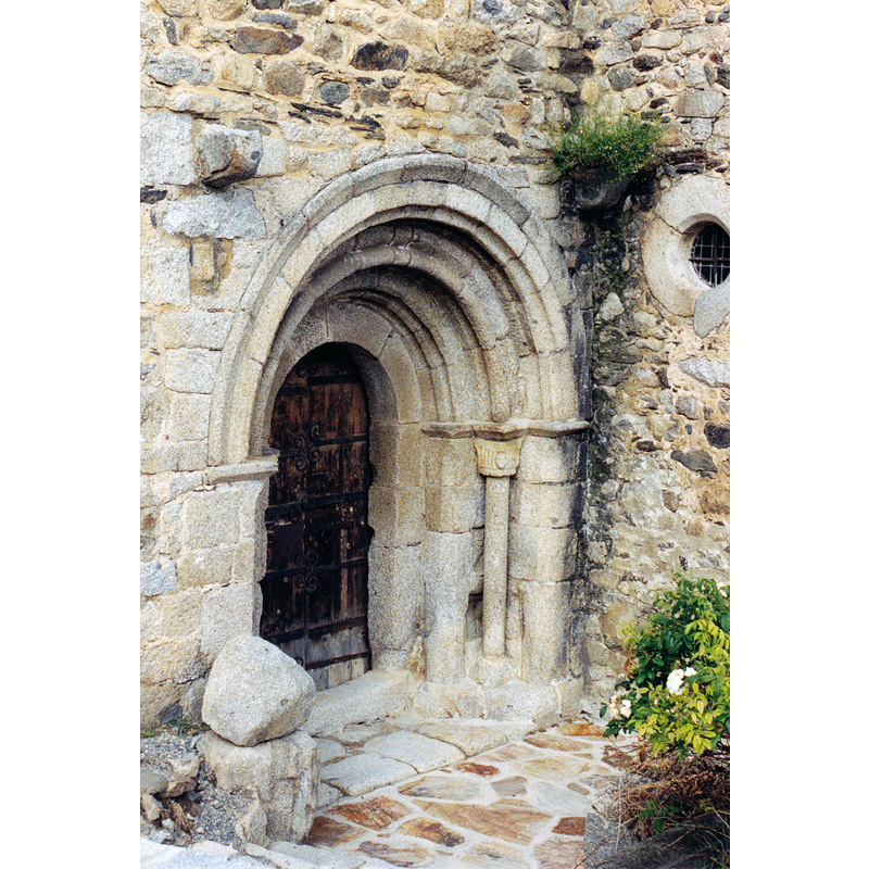
Image copyright © EmDee, 1999
GFDL / CC-BY-SA-3.0,2.5,2.0,1.0
Results: 3 records
view of church exterior - south portal
Scene Description: Source caption: "France - Cerdagne - Église Saint-André d'Angoustrine"
Copyright Statement: Image copyright © EmDee, 1999
Image Source: digital photograph taken in 1999 by EmDee [https://commons.wikimedia.org/wiki/File:Angoustrine_1.jpg] [accessed 18 July 2022]
Copyright Instructions: GFDL / CC-BY-SA-3.0,2.5,2.0,1.0
view of church exterior in context - southwest view
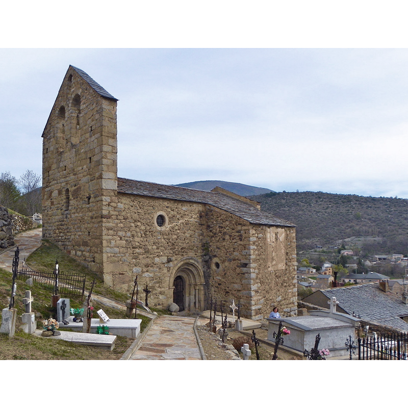
Scene Description: Source caption "Angostrina, església vella i, al fons, la nova"
Copyright Statement: Image copyright © jordi domènech, 2011
Image Source: digital photograph 19 April 2011 by jordi domènech [https://commons.wikimedia.org/wiki/File:Església_vella_d'Angostrina.jpg] [accessed 18 July 2022]
Copyright Instructions: CC-BY-SA-3.0
view of church exterior - southeast view
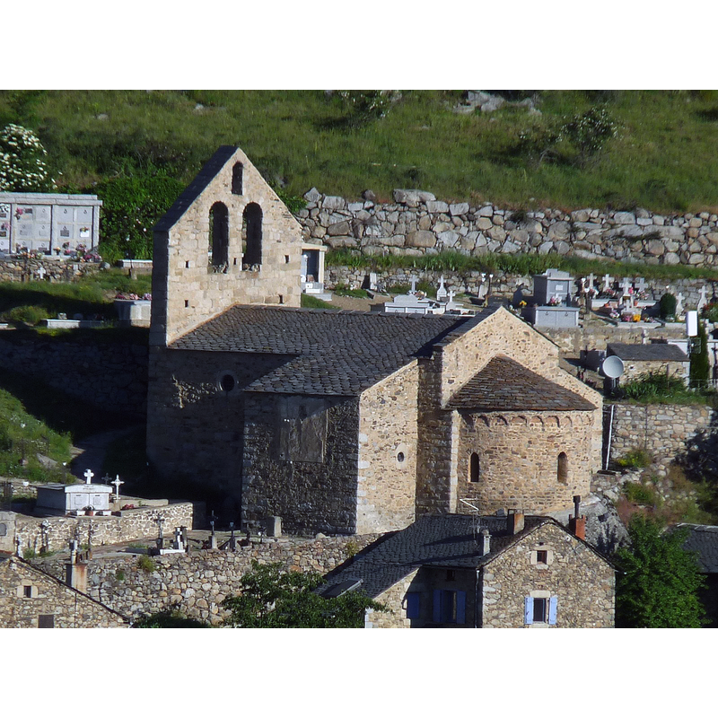
Scene Description: Source caption: "Ancienne église St-André, Angoustrine, P.O., France"
Copyright Statement: Image copyright © Jack ma, 2013
Image Source: digital photograph 7 July 2013 by Jack ma [https://commons.wikimedia.org/wiki/File:Angous_egrom1.JPG] [accessed 18 July 2022]
Copyright Instructions: GFDL / CC-BY-SA-3.0,2.5,2.0,1.0
INFORMATION
Font ID: 08178ANG
Object Type: Stoup
Font Century and Period/Style: 12th - 13th century, Romanesque
Church / Chapel Name: Església de Sant Andreu / Ancienne église paroissiale Saint-André
Font Location in Church: Inside the church, S side of the nave
Church Patron Saint(s): St. Andrew
Church Notes: church documented 10thC; present church chiefly 12thC, with an 11thC apse and lateral chapels added the 18thC -- listed in Mérimée [ref.: PA00103953]: "Eglise romane du 12e siècle située près du cimetière. La nef est voûtée en berceau très aigu et accolée de deux chapelles formant transept, mais d'époque postérieure, voûtées en berceau. Un portail en granit, à archivolte moulurée, avec colonnettes à chapiteaux, s'ouvre au sud. La porte a conservé quelques-unes de ses ferrures. L'abside est décorée d'arcatures. Un campanile percé de trois arcatures, s'élève sur le pignon de la face ouest. L'abside conserve des peintures murales du 13e siècle, étagées sur deux registres comprenant la Cêne au-dessus d'un bandeau à dessins géométriques et d'une suite d'arcades encadrant des personnages pouvant représenter les douze mois de l'année. La fresque a été réalisée à la détrempe, utilisant des tons rouge et noir sur fond gris."
Church Address: 13 Rue de l'Église Romane, 66760 Angoustrine-Villeneuve-des-Escaldes, France
Site Location: Pyrénées-Orientales, Occitanie, France, Europe
Directions to Site: Located off the D-618, in the municipality of Angoustrine Villeneuve les Escaldes / Angostrina Vilanova de les Escaldes, in the Cerdanya region, about 7 km from La Guingueta d'Ix (Bourg-Madame) (access via the D-618)
Historical Region: Languedoc-Roussillon
Additional Comments: disappeared font? (the font of the 11th-12thC church here)
Font Notes:
Click to view
A holy-water stoup located by the south wall of the nave; the basin is cylindrical with a curved underbowl, plain except for a horizontal incision all around; the pedestal base is square with a moulding at the top and bottom. The stoup is visible in an illustration of the interior of the nave in Catalunya romànica (1984- , vol. VII: 80). [NB: we have no information on the font of the 11th-12thC church here]
COORDINATES
UTM: 31T 414442 4704008
Latitude & Longitude (Decimal): 42.483700, 1.959020
Latitude & Longitude (DMS): 42° 29' 1.3" N, 1° 57' 32.5" E
MEDIUM AND MEASUREMENTS
Material: stone
Number of Pieces: two
Font Shape: cylindrical, mounted
Basin Interior Shape: round
Basin Exterior Shape: round
REFERENCES
- Fundació Enciclopèdia Catalana, Catalunya romànica, Barcelona: Fundació Enciclopèdia Catalana, 1984-, vol. VII: 80