Solihull nr. Birmingham
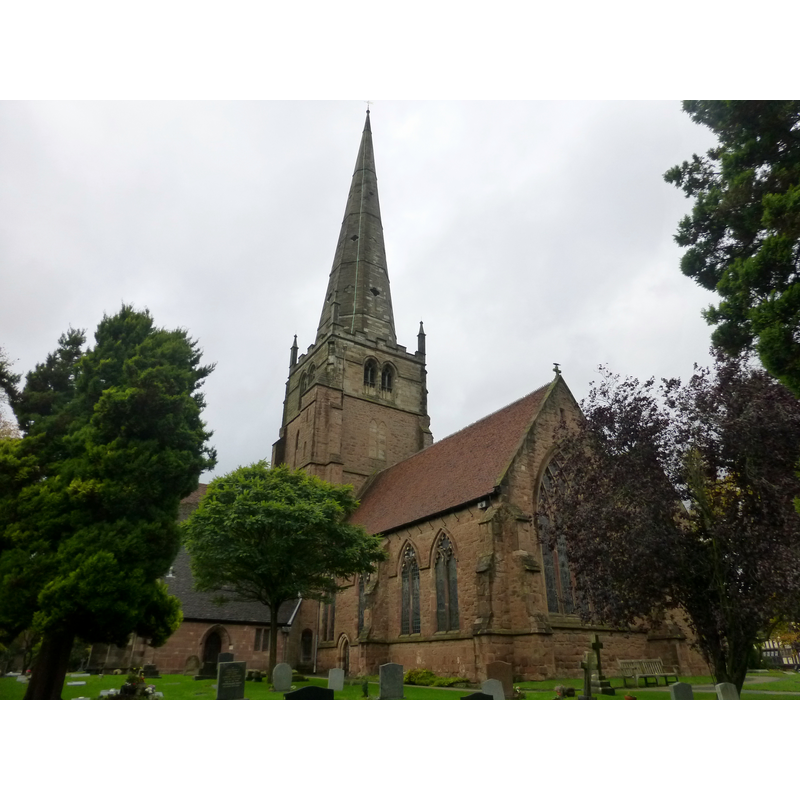
Image copyright © Jimmy Hill, 2013
CC-BY-SA-2.0
Results: 4 records
view of church exterior - southeast view
Copyright Statement: Image copyright © Jimmy Hill, 2013
Image Source: digital photograph taken 22 October 2013 by Jimmy Hill [www.geograph.org.uk/photo/3713550] [accessed 2 February 2015]
Copyright Instructions: CC-BY-SA-2.0
view of church exterior in context
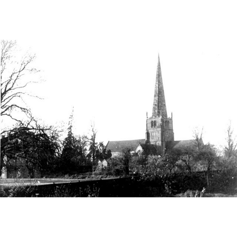
Scene Description: Source caption: "Parish church of St Alphege. A vintage view from Rectory Gardens, showing the south elevation of this fine building, the only medieval cruciform church in the diocese and one of just four in the historic county of Warwickshire. The oldest parts date from 1220 and it was enlarged at various times until the 16th century."
Copyright Statement: Image copyright © Keith Yardley, 1949
Image Source: B&W photograph taken in 1949 by Keith Yardley [www.geograph.org.uk/photo/1177042] [accessed 15 December 2014]
Copyright Instructions: CC-BY-SA-2.0
view of font in context
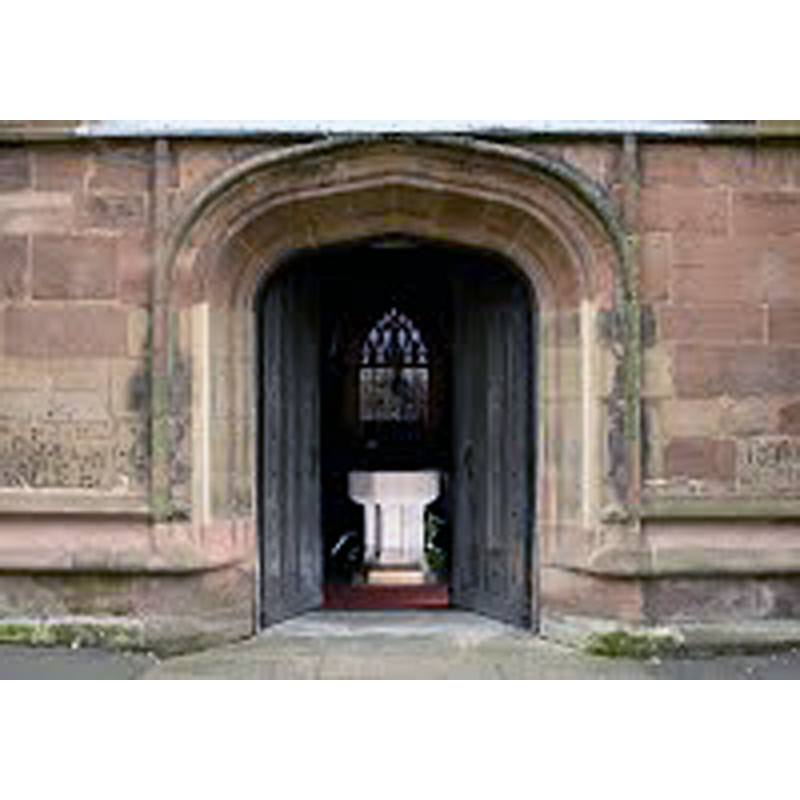
Scene Description: the re-cut font in the context of the west portal
Copyright Statement: Image copyright © Solihull Parish, 2015
Image Source: digital photograph in the Solihull Parish web site [www.solihullparish.org.uk/churches/st-alphege/tour] [accessed 2 February 2015]
Copyright Instructions: No known copyright restriction – Fair Dealing
design element - architectural - column - 8
![[cf. Font notes]](/static-50478a99ec6f36a15d6234548c59f63da52304e5/others/image_not_available.jpg)
Scene Description: [cf. Font notes]
![[cf. Font notes]](/static-50478a99ec6f36a15d6234548c59f63da52304e5/bsi-testing-site/others/image_not_available.jpg)
INFORMATION
Font ID: 07291SOL
Object Type: Baptismal Font1
Font Century and Period/Style: 12th century / 14th century, Norman? / Decorated?
Church / Chapel Name: Parish Church of St. Alphege
Font Location in Church: Inside the church
Church Patron Saint(s): St. Alphege [aka Ælfheah of Canterbury]
Church Address: 74 New Road, Solihull B91 3RB
Site Location: West Midlands, West Midlands, England, United Kingdom
Directions to Site: Solihull is now a SE suburb of Birmingham, 15 km from its city centre, 20 km NW of Warwick
Ecclesiastic Region: Diocese of Birmingham
Historical Region: Hundred of Hemlingford -- formerly Warwickshire
Font Notes:
Click to view
We found no entry for Solihull in the Domesday survey. Lewis' Dictionary of 1848 reports: "The font, of octagonal form, is Norman, with circular pillars at the angles." Listed in Cox & Harvey (1907) as a baptismal font of the Decorated period. The Victoria County History (Warwick, vol. 4, 1947) notes: "There was a late-12th-century church on the site; of this the only evidence left is the east end of the south wall of the nave with a blocked window, and the marks of its steep-pitched roof on the west face of the tower. It was shorter and slightly narrower than the present nave. [...] The font, probably of the 14th century, has been recut. It has a plain octagonal bowl with a moulded lower edge, and a stem having attached round shafts at the angles with moulded capitals and bases." The entry for the Church of St. Alphage in English Heritage [Listing NGR: SP1533079287] (1949) reports a possible medieval baptistery near it: "Ruins approx 50m to s[outh] of probable former rectory or possible baptistery [...] The original function of this ruin is uncertain, but it may have formed part of a medieval rectory or a baptistery connected with the holy well of Saint Alphege."
COORDINATES
UTM: 30U 583222 5807411
Latitude & Longitude (Decimal): 52.410591, -1.776501
Latitude & Longitude (DMS): 52° 24′ 38.13″ N, 1° 46′ 35.41″ W
MEDIUM AND MEASUREMENTS
Material: stone
Font Shape: octagonal, mounted
Basin Interior Shape: round
Basin Exterior Shape: octagonal
REFERENCES
- Victoria County History [online], University of London, 1993-. URL: https://www.british-history.ac.uk.
- Cox, John Charles, English Church Furniture, New York: E.P. Dutton & Co., 1907, p. 224
- Lewis, Samuel, A Topographical Dictionary of England, Comprising the Several Counties, Cities, Boroughs, Corporate and Market Towns, Parishes, Chapelries, and Townships, and the Islands of Guernsy, Jersey, and Man, with Historical and Statistical Descriptions [...], London: S. Lewis, 1831, [www.british-history.ac.uk/report.asp?compid=51286] [accessed 19 December 2006]