Brockenhurst / Brackenhurst / Broceste / Brocknes / Brocknest / Brokehurst / Brokenhurst / Brokenst
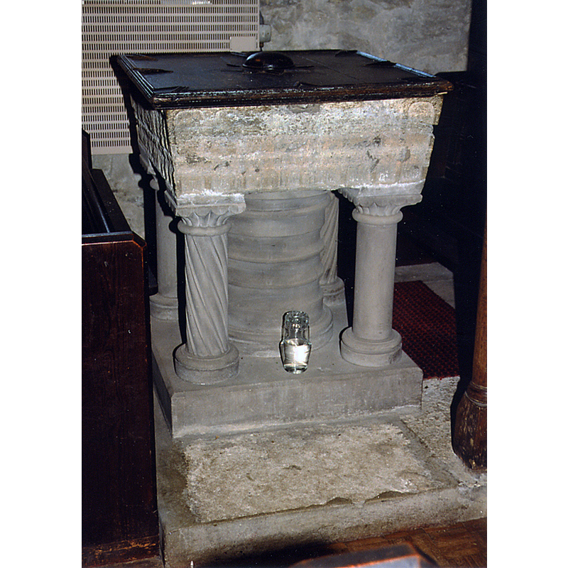
Image copyright © John Salmon, 2013
CC-BY-SA-2.0
Results: 6 records
view of font and cover
Copyright Statement: Image copyright © John Salmon, 2013
Image Source: digital image of a photograph taken 4 August 1998 by John Salmon [www.geograph.org.uk/photo/3314136] [accessed 20 September 2018]
Copyright Instructions: CC-BY-SA-2.0
view of font and cover
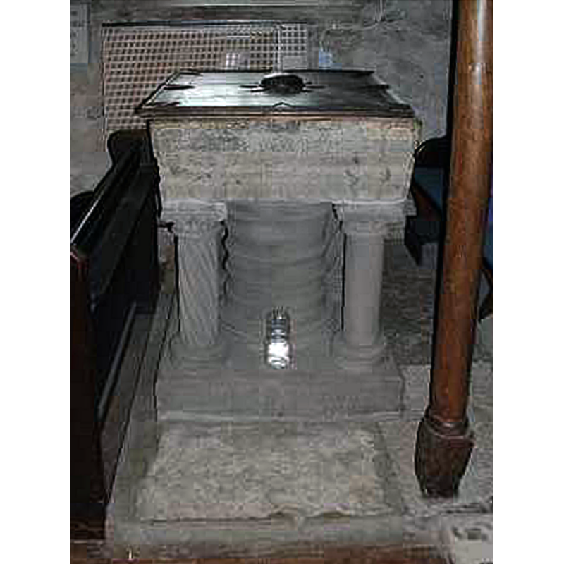
Copyright Statement: Image copyright © Chris Hayley, 2007
Image Source: digital photograph taken by Chris Hayley, of Southern Life [www.southernlife.org.uk]
Copyright Instructions: Standing permission
view of font
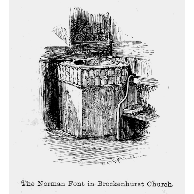
Scene Description: Source caption: "The "Norman Font in Brockenhurst Church" -- notice the base at the time
Copyright Statement: Image copyright © [in the public domain]
Image Source: digital image of a ca. 1862 engraving by W.J. Linton, of a drawing by Walter Crane, in John R. Wise's The New Forest: Its history and its scenery (London: Smith, Elder & Co., 1863) [https://commons.wikimedia.org/wiki/File:The_New_Forest_its_history_and_its_scenery_-_page_233.png] [accessed 20 September 2018]
Copyright Instructions: PD
design element - architectural - arcade - round arches
Scene Description: almost obliterated now
Copyright Statement: Image copyright © Chris Hayley, 2007
Image Source: digital photograph taken by Chris Hayley, of Southern Life [www.southernlife.org.uk]
Copyright Instructions: Standing permission
design element - motifs - leaf - square leaf
Scene Description: almost obliterated now
Copyright Statement: Image copyright © Chris Hayley, 2007
Image Source: digital photograph taken by Chris Hayley, of Southern Life [www.southernlife.org.uk]
Copyright Instructions: Standing permission
view of church exterior - southeast view
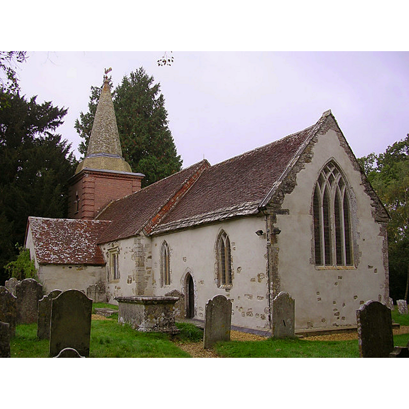
Scene Description: Source caption: "This is the Parish Church of Brockenhurst, reputedly the oldest in the New Forest. The notice board at the gate says that a church has existed on this hilltop site since about 800AD. The Norman builders in 1086 used some of the original Saxon walling as they raised the building. The church was enlarged by the Victorians but in the south wall of the old Nave there is some Saxon herring-bone masonry. The south doorway is a fine example of Norman work with chevron mouldings. The yew tree visible to the left of the tower is probably over 1000 years old."
Copyright Statement: Image copyright © Jim Champion, 2005
Image Source: digital photograph taken 8 October 2005 by Jim Champion [www.geograph.org.uk/photo/62531] [accessed 20 September 2018]
Copyright Instructions: CC-BY-SA-2.0
INFORMATION
Font ID: 06745BRO
Object Type: Baptismal Font1
Font Century and Period/Style: 12th century (late?) [basin only] [composite font], Medieval [composite]
Church / Chapel Name: Parish Church of St. Nicholas
Font Location in Church: Inside the church, at the W end of the nave, S side
Church Patron Saint(s): St. Nicholas of Myra
Church Address: Church Ln, Brockenhurst SO42 7UB, United Kingdom -- Tel.: +44 1590 624584
Site Location: Hampshire, South East, England, United Kingdom
Directions to Site: Located at the southern end of New Forest, 6 km N of Lymington, 22-23 km WSW of Southampton
Ecclesiastic Region: Diocese of Winchester
Historical Region: Hundred of New Forest / Hundred of Boldre [in Domesday]
Additional Comments: altered font (the present font has a modern base) -- disappeared font? (the one from the Domesday-time church here)
Font Notes:
Click to view
There is an entry for Brockwnhurst [variant spelling] in the Domesday survey [http://opendomesday.org/place/SU3002/brockenhurst/] [accessed 20 September 2018]; it reports a church in it. The National Gazetteer of 1868 reports "a curious old font" in this church. White (1878) writes: "The Norman font is large enough for the immersion of infants." Described in Cox & Harvey (1907) as a baptismal font of the Norman period made of Purbeck marble. [NB: the font appears listed as "Brackenhurst" in C&H]. The entry for this parish in the Victoria County History (Hampshire, vol. 4, 1911) notes: "Brockenhurst Church, one of the only two churches in the New Forest mentioned in the Domesday Survey [...] The font of Purbeck marble has a square late 12th-century bowl with shallow round-headed arcades and square leaf pattern on the sides. The circular central and angle shafts are modern." The entry for this church in Historic England [Listing NGR: SU2788102630] notes: "Late C12 Purbeck font of square bowl with roundheaded arcading, on replaced central column and corner columns. C17 font cover". Noted and illustrated in Southern Life [http://www.southernlife.org.uk/brockchu.htm] [accessed 5 August 2010]: "In the corner at the west end is the Font, dating from the 12th century, a lead-lined bowl of Purbeck stone with shallow arcading and leaf-patterns on the four sides, with a wooden cover of 17th century design. The stand is modern." Noted in Leach (1975) as a font made of Purbeck marble: "bowl with panels and quatrefoil leaf patterns on faces; central stem and subsidiary shafts modern" [source given: VCH, 4, 1911].
Credit and Acknowledgements: We are grateful to Chris Hayley, of Southern Life [www.southernlife.org.uk] for his photograph of this font
COORDINATES
UTM: 30U 600873 5630218
Latitude & Longitude (Decimal): 50.8149, -1.5681
Latitude & Longitude (DMS): 50° 48′ 53.64″ N, 1° 34′ 5.16″ W
MEDIUM AND MEASUREMENTS
Material: stone, limestone (Purbeck marble)
Font Shape: square, mounted
Basin Interior Shape: round
Basin Exterior Shape: square
Drainage Notes: lead-lined
LID INFORMATION
Date: 17th-century?
Material: wood, oak
Apparatus: no
Notes: square, plain and flat
REFERENCES
- The National Gazetteer: a Topographical Dictionary of the British Isles, London: Virtue & Co., 1868
- Victoria County History [online], University of London, 1993-. URL: https://www.british-history.ac.uk.
- Cox, John Charles, English Church Furniture, New York: E.P. Dutton & Co., 1907, p. 200
- Holmes, Edric, Wanderings in Wessex: an Exploration of the Southern Realm from Itchen to Otter, London: Robert Scott Roxburghe House, [1922]
- Leach, Rosemary, A Investigation into the use of Purbeck Marble in Medieval England, Hartlepool: E.W. Harrisons & Sons, 1975, p. 70
- White, William, History, gazetteer and directory of the County of Hampshire including the Isle of Wight, and [...], Sheffield: William White, 1878, p. 176