Drewsteignton / Drew's Teignton / Taintone
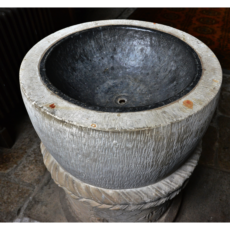
Image copyright © Michael Garlick, 2015
CC-BY-SA-2.5
Results: 9 records
view of font - upper view
Scene Description: Source caption: "Drewsteignton, Holy Trinity Church: The font bowl" [NB: a modern replacement [cf. FontNotes]]
Copyright Statement: Image copyright © Michael Garlick, 2015
Image Source: digital photograph 17 August 2015 by Michael Garlick [www.geograph.org.uk/photo/4758514] [accessed 30 January 2022]
Copyright Instructions: CC-BY-SA-2.5
view of font
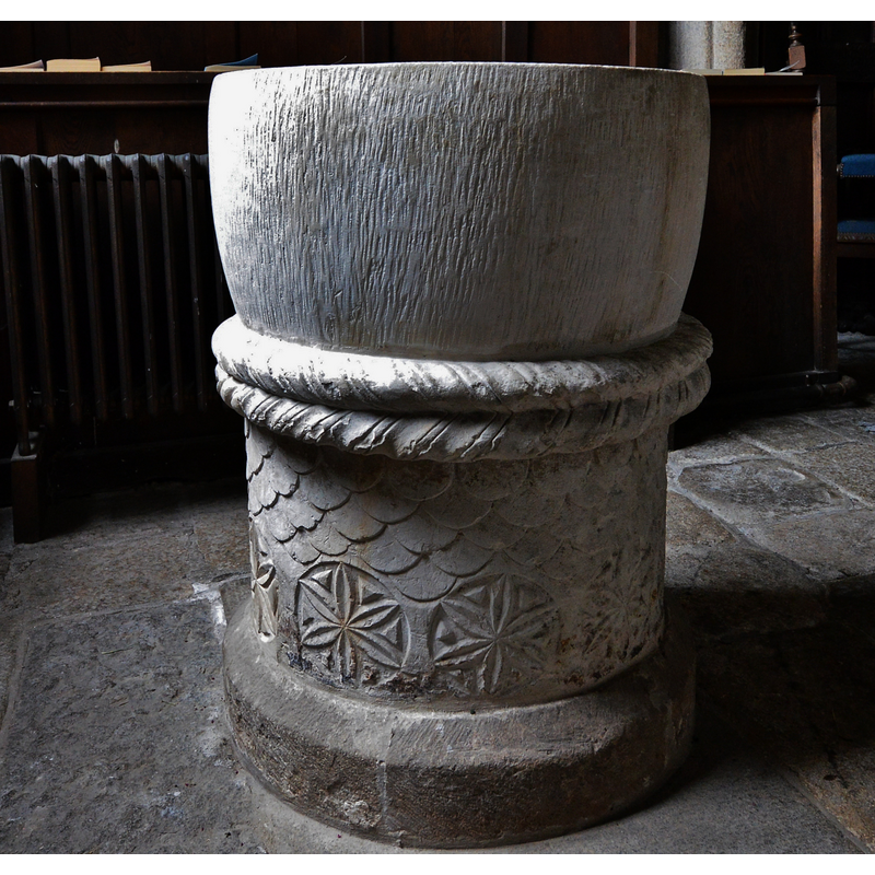
Scene Description: Source caption: "Drewsteignton, Holy Trinity Church: The font. There was a Norman font; only the pedestal remains as an 18th century roof collapse shattered the bowl which was not repaired."
Copyright Statement: Image copyright © Michael Garlick, 2015
Image Source: digital photograph 17 August 2015 by Michael Garlick [www.geograph.org.uk/photo/4758512] [accessed 30 January 2022]
Copyright Instructions: CC-BY-SA-2.5
view of font
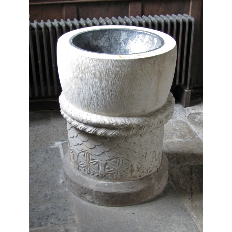
Scene Description: Source caption: "Drewsteignton - Font. Inside the parish church, Holy Trinity."
Copyright Statement: Image copyright © Colin Smith, 2022
Image Source: digital photograph 30 July 2021 by Colin Smith [www.geograph.org.uk/photo/6947929] [accesed 3o January 2022]
Copyright Instructions: CC-BY-SA-2.5
view of church exterior - west tower - portal
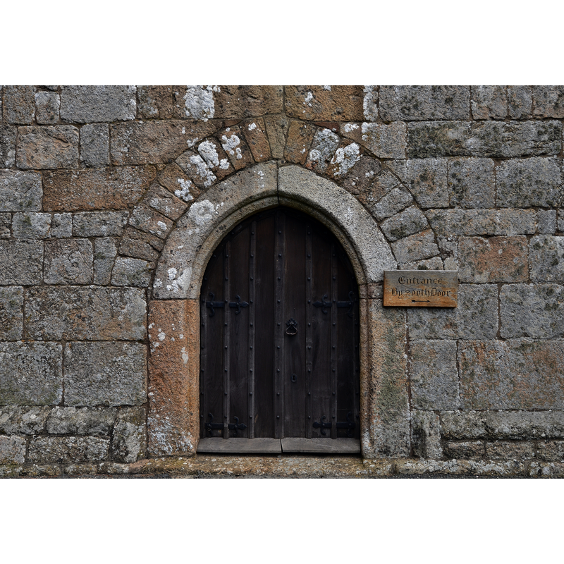
Scene Description: Source caption: "Drewsteignton, Holy Trinity Church: The west tower entrance"
Copyright Statement: Image copyright © Michael Garlick, 2015
Image Source: digital photograph 17 August 2015 by Michael Garlick [www.geograph.org.uk/photo/4758480] [accessed 30 January 2022]
Copyright Instructions: CC-BY-SA-2.5
view of church exterior in context - east view
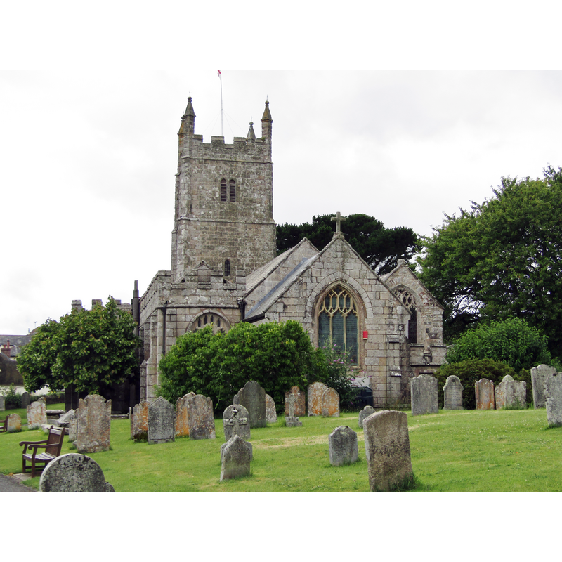
Scene Description: Source caption: "Drewsteignton - Holy Trinity Church. The parish church was built mainly in the 15th century in Perpendicular style."
Copyright Statement: Image copyright © Colin Smith, 2022
Image Source: digital photograph 30 July 2021 by Colin Smith [www.geograph.org.uk/photo/6947944] [accesed 3o January 2022]
Copyright Instructions: CC-BY-SA-2.5
view of church interior - looking east
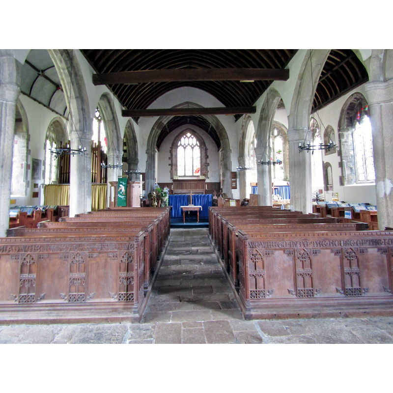
Scene Description: Source caption: "Drewsteignton - Holy Trinity Church. Inside view of the parish church."
Copyright Statement: Image copyright © Colin Smith, 2022
Image Source: digital photograph 30 July 2021 by Colin Smith [www.geograph.org.uk/photo/6947941] [accesed 3o January 2022]
Copyright Instructions: CC-BY-SA-2.5
design element - patterns - scalloped
Scene Description: Source caption: "Drewsteignton, Holy Trinity Church: Detail of the Norman font pedestal"
Copyright Statement: Image copyright © Michael Garlick, 2015
Image Source: digital photograph 17 August 2015 by Michael Garlick [www.geograph.org.uk/photo/4758520] [accessed 30 January 2022]
Copyright Instructions: CC-BY-SA-2.5
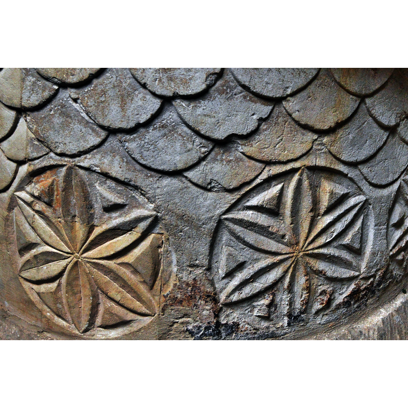
design element - motifs - floral - 6-petal - in a circle - with inserts
Scene Description: Source caption: "Drewsteignton, Holy Trinity Church: Detail of the Norman font pedestal" [NB: of the two motifs visible in this image most of the one on the left is modern; the insert of new stone is easily discernible here]
Copyright Statement: Image copyright © Michael Garlick, 2015
Image Source: digital photograph 17 August 2015 by Michael Garlick [www.geograph.org.uk/photo/4758520] [accessed 30 January 2022]
Copyright Instructions: CC-BY-SA-2.5
design element - motifs - rope moulding - parallel - opposed thread directions
Scene Description: appears to be part of the surviving base block, not of the replacement basin
Copyright Statement: Image copyright © Michael Garlick, 2015
Image Source: digital photograph 17 August 2015 by Michael Garlick [www.geograph.org.uk/photo/4758512] [accessed 30 January 2022]
Copyright Instructions: CC-BY-SA-2.5
INFORMATION
Font ID: 06613DRE
Object Type: Baptismal Font1
Font Century and Period/Style: 12th century [base only], Medieval [composite]
Church / Chapel Name: Parish Church of the Holy Trinity
Font Location in Church: Inside the church
Church Patron Saint(s): The Holy Trinity
Church Address: Drewsteignton, Exeter EX6 6QN, United Kingdom -- Tel.: +44 1647 432265
Site Location: Devon, South West, England, United Kingdom
Directions to Site: Located on the NW reaches of Dartmoor, 16-17 km W of Exeter
Ecclesiastic Region: Diocese of Exeter
Historical Region: Hundred of Wonford [in Domesday]
Additional Comments: replica font? / altered font / damaged font (the basin was shattered and not repaired [cf. FontNotes])
Font Notes:
Click to view
There is an entry for Drewsteignton [variant spelling] in the Domesday survey [https://opendomesday.org/place/SX7390/drewsteignton/] [accessed 30 January 2022] but it mentions neither priest nor church in it. Listed in Lysons (1806-1822) as a baptismal font "among many of circular form and an early age, enriched with various carved mouldings, wreaths, scrolls, or foliage". Lewis' Dictionary of 1848 reports "a fine Norman font" in this church. The font is described in The Gentlemans' Magazine (issue of September 1862: 297): "The font is circular, and apparently of Early English work; but there is a broad iron clamp surrounding, nay, almost hiding the upper rim, and such a profusion of cement about other portions of the relic, that it is unsafe to do more than guess at its precise date." Listed in Cox & Harvey (1907) as having a baptismal font of the Norman period. Stabb (1908), however, notes that "the font is probably a copy of an older one". Not mentioned in Pevsner (1952). The church is listed in Historic England [Listing NGR: SX7363890850] but there is no mention of a font in it. Michael Garlick [https://www.geograph.org.uk/photo/4758512] [accessed 30 January 2022] captions his photograph of the present font: "There was a Norman font; only the pedestal remains as an 18th century roof collapse shattered the bowl which was not repaired."
Credit and Acknowledgements: We are grateful to Colin Smith for his photographs of this church and font
COORDINATES
UTM: 30U 444143 5617152
Latitude & Longitude (Decimal): 50.7035, -3.791
Latitude & Longitude (DMS): 50° 42' 12.6" N, 3° 47' 27.6" W
MEDIUM AND MEASUREMENTS
Material: stone
Font Shape: round
Basin Interior Shape: round
Basin Exterior Shape: round
REFERENCES
- Cox, John Charles, English Church Furniture, New York: E.P. Dutton & Co., 1907, p. 196
- Lewis, Samuel, A Topographical Dictionary of England, Comprising the Several Counties, Cities, Boroughs, Corporate and Market Towns, Parishes, Chapelries, and Townships, and the Islands of Guernsy, Jersey, and Man, with Historical and Statistical Descriptions [...], London: S. Lewis, 1831, [www.british-history.ac.uk/report.asp?compid=51330] [accessed 12 March 2007]
- Lysons, Daniel, Magna Britannia, being a concise topographical account of the several counties of Great Britain, London: Printed for T. Cadell and W. Davies, 1806-1822, vol. 6: p. cccxxx
- Stabb, John, Some old Devon churches, their roods, pulpits, fonts, etc., London: Simkin, [et al.], 1908-1916, p. 89