Beaminster / Beiminstre / Beminster
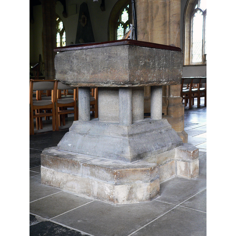
Image copyright © Ray Jennings, 2011
CC-BY-SA-2.5
Results: 9 records
view of font and cover
Scene Description: Source caption: "St. Mary of The Anunciation, Beaminster, Dorset. The Norman font"
Copyright Statement: Image copyright © Ray Jennings, 2011
Image Source: digital photograph 17 June 2011 by Ray Jennings [https://www.geograph.org.uk/photo/7372367] [accessed 11 February 2023]
Copyright Instructions: CC-BY-SA-2.5
view of font and context
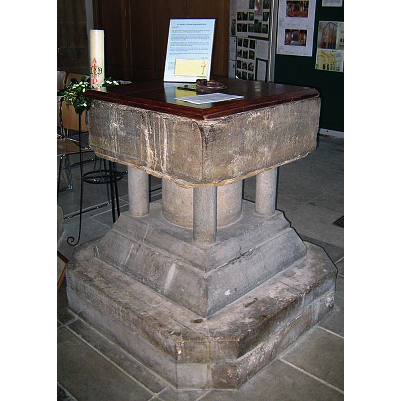
Scene Description: Source caption: "The font - St Mary's Beaminster Pevsner mentions the font as "square, Purbeck marble, C12 or C13, defaced"".
Copyright Statement: Image copyright © Sara Smith, 2009
Image Source: digital photograph 21 February 2009 by Sara Smith [https://commons.wikimedia.org/wiki/File:The_font_-_St_Mary%27s_Beaminster_-_geograph.org.uk_-_1173552.jpg] [accessed 11 February 2023]
Copyright Instructions: CC-BY-SA-2.5 Generic
design element - architectural - arcade - blind - round arches
Scene Description: only the basin is original [cf. FontNotes]
Copyright Statement: Image copyright © Sara Smith, 2009
Image Source: digital photograph 21 February 2009 by Sara Smith [https://commons.wikimedia.org/wiki/File:The_font_-_St_Mary%27s_Beaminster_-_geograph.org.uk_-_1173552.jpg] [accessed 11 February 2023]
Copyright Instructions: CC-BY-SA-2.5 Generic
view of church exterior - southeast view
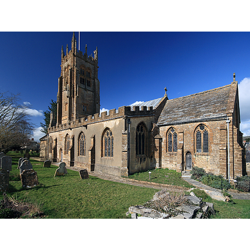
Scene Description: Source caption: "St Mary's Parish Church - Beaminster. Dating from the C13 and C15, its best feature is its magnificent early C16 west tower. The tower served a grim purpose after the Monmouth Rebellion of 1685, when the butchered quarters of those executed were hung like carrion from its lofty heights."
Copyright Statement: Image copyright © Mike Searle, 2008
Image Source: digital photograph 7 March 2008 by Mike Searle [https://www.geograph.org.uk/photo/717547] [accessed 11 February 2023]
Copyright Instructions: CC-BY-SA-2.5
view of church exterior - northeast view
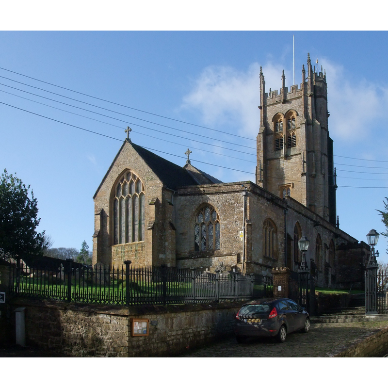
Scene Description: Source caption: "Church of St Mary of the Annunciation, Beaminster"
Copyright Statement: Image copyright © Tim Heaton, 2013
Image Source: edited detail of a digital photograph 30 January 2013 by Tim Heaton [https://www.geograph.org.uk/photo/3330760] [accessed 11 February 2023]
Copyright Instructions: CC-BY-SA-2.5
view of church interior - nave - capital
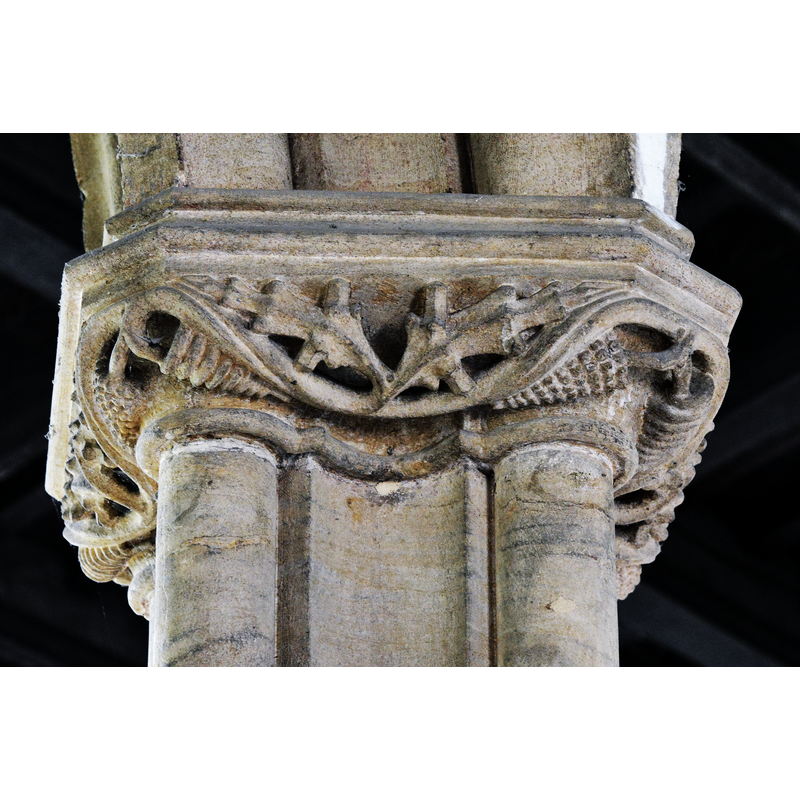
Scene Description: Source caption: "Beaminster, St. Mary's Church: Vine leaf capital"
Copyright Statement: Image copyright © Michael Garlick, 2017
Image Source: digital photograph 6 April 2017 by Michael Garlick [https://www.geograph.org.uk/photo/5353608] [accessed 11 February 2023]
Copyright Instructions: CC-BY-SA-2.5
view of church interior - looking east
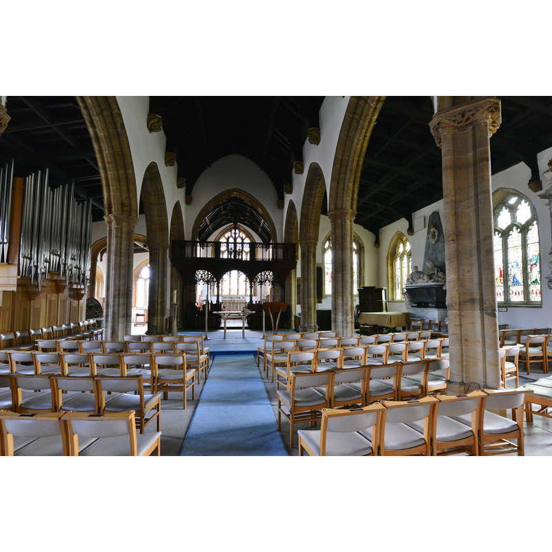
Scene Description: Source caption: "Beaminster, St. Mary's Church: The nave"
Copyright Statement: Image copyright © Michael Garlick, 2017
Image Source: digital photograph 6 April 2017 by Michael Garlick [https://www.geograph.org.uk/photo/5353538] [accessed 11 February 2023]
Copyright Instructions: CC-BY-SA-2.5
view of font and cover in context
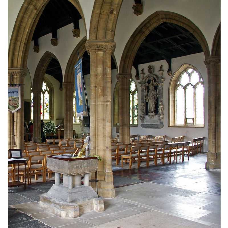
Scene Description: Source caption: "St. Mary of the Annunciation, Beaminster, Dorset"
Copyright Statement: Image copyright © Ray Jennings, 2011
Image Source: digital photograph 17 June 2011 by Ray Jennings [https://www.geograph.org.uk/photo/7364143] [accessed 11 February 2023]
Copyright Instructions: CC-BY-SA-2.5
view of font and cover in context

Copyright Statement: Image copyright © Gary Parsons, 1995
Image Source: Gary A. Parsons (1995) [http://parsons.best.vwh.net/font.html]
Copyright Instructions: PERMISSION NOT AVAILABLE -- IMAGE NOT FOR PUBLIC USE
INFORMATION
Font ID: 06592BEA
Object Type: Baptismal Font1
Font Century and Period/Style: 12th century (late?) [basin only] [composite font], Medieval [composite]
Church / Chapel Name: Parish Church of St. Mary of the Annunciation
Font Location in Church: Inside the church, NW side of the nave
Church Patron Saint(s): The Annunciation to St. Mary
Church Address: Church St., Beaminster DT8 3BA, United Kingdom -- Tel.: +44 1308 862320
Site Location: Dorset, South West, England, United Kingdom
Directions to Site: Located off the A3006-B3163 [aka Whitcombe Rd] crossroads, 12-13 km N of Bridport
Historical Region: Hundred of Beaminster
Additional Comments: damaged font / recycled font: the 12th-century basin found in a stonemason's yard; fitted with a new base and restored to the church [e-mail sent to Gary Parsons req. permit to use image (12/3/2004]
Font Notes:
Click to view
There is an entry for Beaminster [variant spelling] in the Domesday survey [https://opendomesday.org/place/ST4701/beaminster/] [accessed 11 February 2023]; it mentions neither cleric nor church in it. Described in Pulman (1854): "the font stands under the tower, in its proper position near the western entrance of the church. It is of blue lias, square and shallow. One one of the sides are carved some circular arches, as if of Norman date, to which they are not improbably a truthful index; while the vilest of rude chiseling ('enlightened age'-work, of course,) has effectuallt erased from the other sides, and from the top, every trace of ornament and of antiquity." Noted in Mee (1939) : "The square bowl of the font is Norman." Described and illustrated in Parsons (1995): "St. Mary's original Norman baptismal font that consists of a late 12th century bowl of Purbeck Marble supported on a modern base [...]; the font was replaced in the 19th century during major restoration, possibly because it was lost of thought to be destroyed. In 1927, the original bowl of St. Mary's baptismal font was discovered in the stonemason's yard, unfortunately without its base. A new base was constructed and the baptismal font is now restored to its former place of prominence in the rear of the Nave" [source: In Gary A. Parsons [http://parsons.best.vwh.net/font.html], 1995, "compiled from an article by Mr. Peter Courtney (1957)"]. In Newman & Pevsner (1972): "Font. Square, Purbeck marble, C12 or C13, defaced." The entry for this church in Historic England [Listing NGR: ST4789401249] notes: "Parish Church. C13, C15 and C16 [...] font, late C12, Purbeck marble with square shallow bowl with round arcading on one side. Round stem with 4 color[sic]ettes." Noted in Leach (1975) as a font made of Purbeck marble; no details given [source given: Dr. G. Dru Drury].
COORDINATES
UTM: 30U 518259 5628550
Latitude & Longitude (Decimal): 50.808393, -2.740852
Latitude & Longitude (DMS): 50° 48′ 30.22″ N, 2° 44′ 27.07″ W
MEDIUM AND MEASUREMENTS
Material: stone, limestone (Purbeck Marble?) / (lias?)
Font Shape: square, mounted
Basin Interior Shape: round
Basin Exterior Shape: square
LID INFORMATION
Date: modern
Material: wood
Apparatus: no
Notes: plain, flat square lid; modern
REFERENCES
- Leach, Rosemary, A Investigation into the use of Purbeck Marble in Medieval England, Hartlepool: E.W. Harrisons & Sons, 1975, p. 69
- Mee, Arthur, The King's England. Dorset: Thomas Hardy's Country, London: Hodder & Stoughton, 1939, p. 23
- Pevsner, Nikolaus, Dorset, Harmondsworth: Penguin, 1972, p. 85
- Pulman, George P.R., The Book of the Axe: containing a piscatorial description of the stream, and a history of all the parishes and remarkable spots upon its banks […], London: Longman, Brown, Green, and Longmans, 1854, p. 53 / [http://books.google.ca/books?id=7vcGAAAAQAAJ&pg=PA256&lpg=PA256&dq=hawkchurch+church&source=bl&ots=TjjxLXpAV-&sig=_dtNZhp4BN5ikgeudqfOs24TWIU&hl=en&sa=X&oi=book_result&resnum=1&ct=result#PPR1,M1] [accessed 3 February 2009]