Milland / Tuxlith Chapel / Tuxlythe Chapel
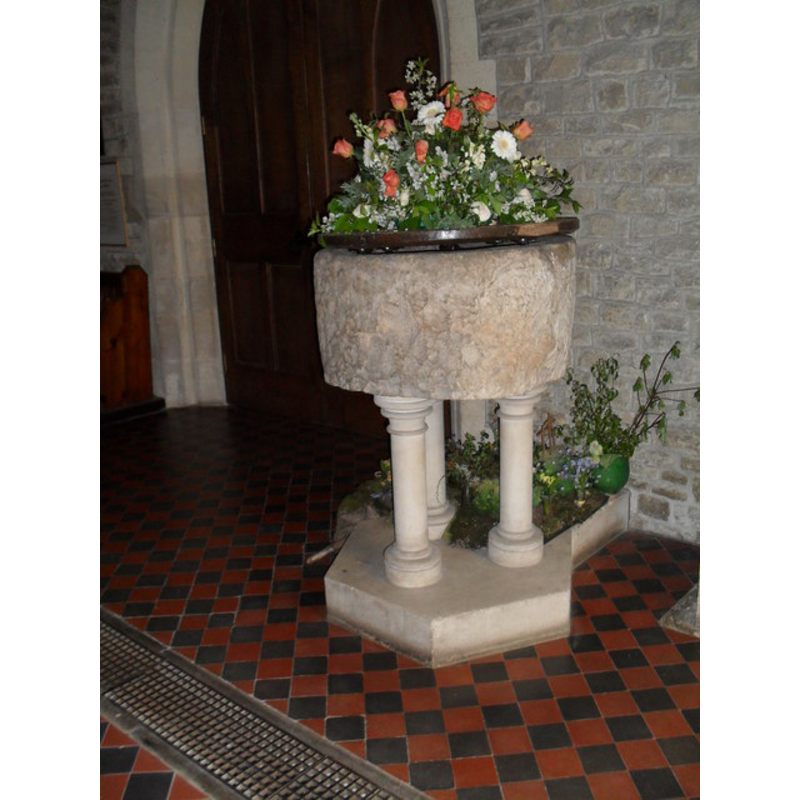
Image copyright © Basher Eyre, 2010
CC-BY-SA-3.0
Results: 5 records
view of font and cover
Scene Description: inside Luke's [cf. FontNotes]
Copyright Statement: Image copyright © Basher Eyre, 2010
Image Source: digital photograph taken 9 May 2010 by Basher Eyre [www.geograph.org.uk/photo/1864236] [accessed 30 January 2013]
Copyright Instructions: CC-BY-SA-3.0
view of church exterior - southeast view
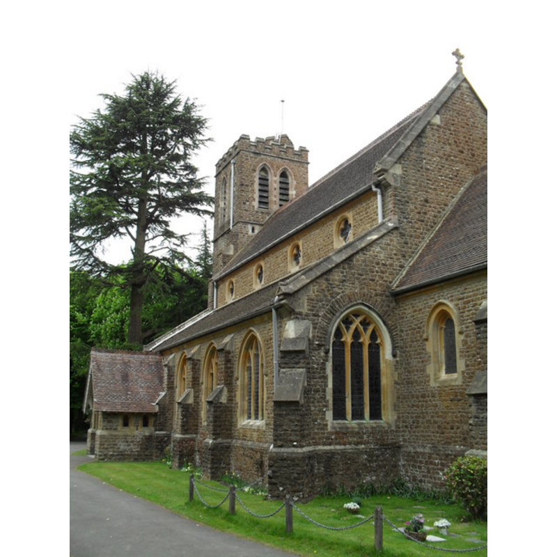
Scene Description: St. Luke's
Copyright Statement: Image copyright © Basher Eyre, 2010
Image Source: digital photograph taken 9 May 2010 by Basher Eyre [www.geograph.org.uk/photo/1865884] [accessed 30 January 2013]
Copyright Instructions: CC-BY-SA-3.0
view of church exterior - northeast view
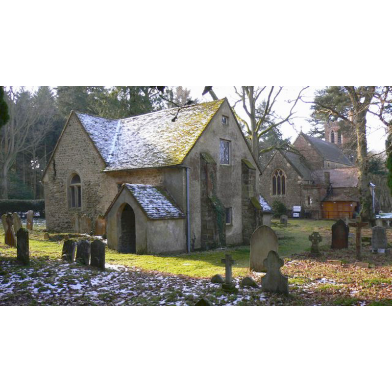
Scene Description: Tuxlith Chapel -- with the Church of St. Luke in the background, to the right
Copyright Statement: Image copyright © Shazz, 2009
Image Source: digital photograph taken 8 February 2009 by Shazz [www.geograph.org.uk/photo/1153831] [accessed 30 January 2013]
Copyright Instructions: CC-BY-SA-3.0
view of church exterior - southwest view
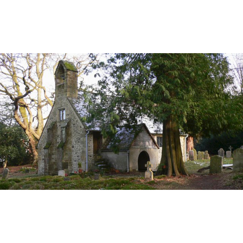
Scene Description: Tuxlith Chapel
Copyright Statement: Image copyright © Shazz, 2009
Image Source: digital photograph taken 8 February 2009 by Shazz [www.geograph.org.uk/photo/1153779] [accessed 30 January 2013]
Copyright Instructions: CC-BY-SA-3.0
view of church exterior - information sign
![Tuxlith Chapel
Tuxlith Info Board digital photograph taken 8 February 2009 by Shazz [www.geograph.org.uk/photo/1153796] [accessed 30 January 2013]
Tuxlith Chapel EXT SW digital photograph taken 8 February 2009 by Shazz [www.geograph.org.uk/photo/1153779] [accessed 30 January 2013]
Tuxlith Chapel EXT NE digital photograph taken 8 February 2009 by Shazz [www.geograph.org.uk/photo/1153831] [accessed 30 January 2013] ***NOTICE THE VICTORIAN CHURCH OF ST LUKE RIGHT BEHIND THE CHAPEL***
Milland St Luke Church digital photograph taken 9 May 2010 by Basher Eyre [www.geograph.org.uk/photo/1865884] [accessed 30 January 2013]
Milland StLukeChurchFONTdigital photograph taken 9 May 2010 by Basher Eyre [www.geograph.org.uk/photo/1864236] [accessed 30 January 2013]](/static-50478a99ec6f36a15d6234548c59f63da52304e5/compressed/1130407093_compressed.png)
Scene Description: Tuxlith Chapel
Tuxlith Info Board digital photograph taken 8 February 2009 by Shazz [www.geograph.org.uk/photo/1153796] [accessed 30 January 2013]
Tuxlith Chapel EXT SW digital photograph taken 8 February 2009 by Shazz [www.geograph.org.uk/photo/1153779] [accessed 30 January 2013]
Tuxlith Chapel EXT NE digital photograph taken 8 February 2009 by Shazz [www.geograph.org.uk/photo/1153831] [accessed 30 January 2013] ***NOTICE THE VICTORIAN CHURCH OF ST LUKE RIGHT BEHIND THE CHAPEL***
Milland St Luke Church digital photograph taken 9 May 2010 by Basher Eyre [www.geograph.org.uk/photo/1865884] [accessed 30 January 2013]
Milland StLukeChurchFONTdigital photograph taken 9 May 2010 by Basher Eyre [www.geograph.org.uk/photo/1864236] [accessed 30 January 2013]
Copyright Statement: Image copyright © Shazz, 2009
Image Source: photograph taken 8 February 2009 by Shazz [www.geograph.org.uk/photo/1153796] [accessed 30 January 2013]
Copyright Instructions: CC-BY-SA-3.0
INFORMATION
Font ID: 06536MIL
Object Type: Baptismal Font1
Font Century and Period/Style: [composite]
Church / Chapel Name: Parish Church of St. Luke [orig. from Milland old chapel, aka Tuxlith Chapel]
Font Location in Church: Inside the new Victorian church
Church Patron Saint(s): St. Luke
Church Notes: Kelly's Directory of 1867 notes: "TUXLYTHE (or Milland) is a chapelry belonging to Trotton" -- "Tuxlith Chapel" is the name now given to Milland's Old Chapel, now redundant and in the care of the Friends of Friendless Churches.
Church Address: Milland, West Sussex, GU30 7JL
Site Location: West Sussex, South East, England, United Kingdom
Directions to Site: Located just off the B2070, 7 km NW of Midhurst, 10 km NE of Petersfield -- the church is located off the between Liphook and Rake
Ecclesiastic Region: Diocese of Chichester
Additional Comments: disused font / abandoned or buried font -- re-cycled font
Font Notes:
Click to view
Harrison (1920) writes: "The circular old font on three E[arly] E[nglish] pillars was found when preparing site of the new church in which it is placed." Described in Whiteman (1994) as the font from the old chapel-at-ease to Trotton, probably dated to the 16th century: "the old font is now in the modern church" [NB: the old Milland Chapel still exists, known also as Tuxlith [aka Tuxlythe] Chapel, right next door to the Victorian church; it is now redundant].
COORDINATES
UTM: 30U 652538 5657394
Latitude & Longitude (Decimal): 51.0478, -0.8238
Latitude & Longitude (DMS): 51° 2′ 52.08″ N, 0° 49′ 25.68″ W
MEDIUM AND MEASUREMENTS
Material: stone
Font Shape: tub-shaped, mounted
Basin Interior Shape: round
Basin Exterior Shape: round
REFERENCES
- Whiteman, Ken, Ancient Churches of Suffolk, Seaford, East Sussex: S.B. Publications, 1998, p. 108