Hooe / Hov / Hou
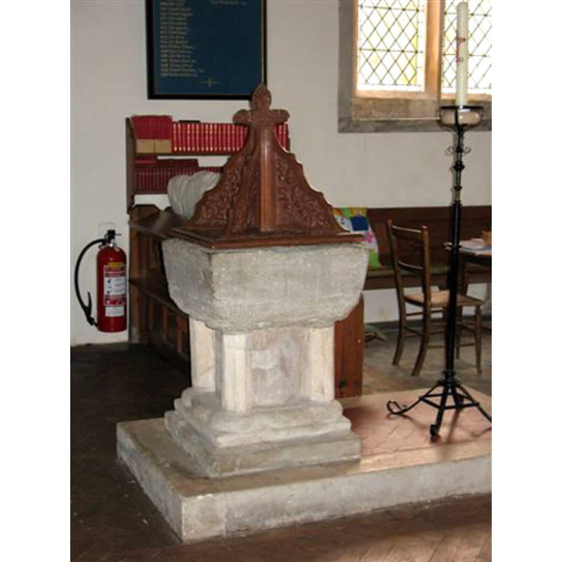
Image copyright © Carole Vidler, 2010
Standing permission
Results: 5 records
view of font and cover
Copyright Statement: Image copyright © Carole Vidler, 2010
Image Source: digital photograph by Carole Vidler [www.vidler-family.co.uk/Life%20in%20Hooe,%20East%20Sussex.htm] [accessed 20 February 2010]
Copyright Instructions: Standing permission
view of church exterior - southeast view
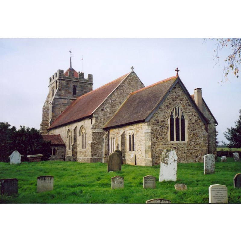
Copyright Statement: Image copyright © Carole Vidler, 2010
Image Source: digital photograph by Carole Vidler [www.vidler-family.co.uk/Life%20in%20Hooe,%20East%20Sussex.htm] [accessed 20 February 2010]
Copyright Instructions: Standing permission
view of church interior - nave - looking east
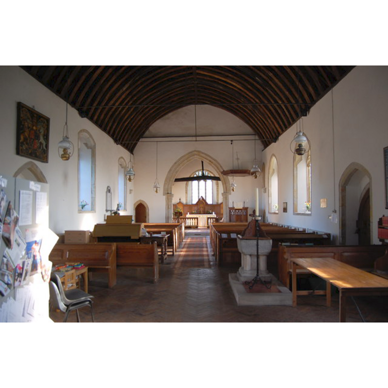
Scene Description: the font in the foreground (west end), right (south) side
Copyright Statement: Image copyright © Julian P Guffogg, 2013
Image Source: digital photograph taken 8 January 2013 by Julian P Guffogg [www.geograph.org.uk/photo/3299402] [accessed 22 January 2013]
Copyright Instructions: CC-BY-SA-3.0
design element - architectural - column - clustered columns - with capitals and bases - 4
Copyright Statement: Image copyright © Carole Vidler, 2010
Image Source: digital photograph by Carole Vidler [www.vidler-family.co.uk/Life%20in%20Hooe,%20East%20Sussex.htm] [accessed 20 February 2010]
Copyright Instructions: Standing permission
view of font and stoup

Copyright Statement: Image copyright © [s.n., s.d.]
Image Source: local drawings posted in www.jwnewport.co.uk/HChurch/Images/Page15.jpg [accessed 22 January 2013]
Copyright Instructions: PERMISSION [requested] NOT AVAILABLE -- IMAGE NOT FOR PUBLIC USE
INFORMATION
Font ID: 06520HOO
Object Type: Baptismal Font1
Font Century and Period/Style: 12th century, Late Norman
Church / Chapel Name: Parish Church of St. Oswald [or St. James]
Font Location in Church: Inside the church, at the W end
Church Patron Saint(s): St. Oswald of Nothumbria [or St. James]
Site Location: East Sussex, South East, England, United Kingdom
Directions to Site: Located on the B2095, 4 km NW of Bexhill, about 10 km WWN of Hastings
Ecclesiastic Region: Diocese of Chichester
Historical Region: Hundred of Ninfield -- Rape of Hastings -- Sussex
Additional Comments: altered font? (is the base modern, 19thC? or just the plinth?) -- e-mailed Carole Vidler req/g permission to repro (20 Feb 2010 -- permission received) -- permission to repro drawings req'd 22 Jan 2013 [no reply rec'd]
Font Notes:
Click to view
Harrison (1920) reports a late-Norman font in this church. Described in Whiteman (1994): "The 12th-century square font is of Sussex marble and rest on a central stem with four shafts." The base is monolithic, the colonnettes carved at the angles, rather than 'clustered'. On a modern rectangular plinth. Modern wooden cover. There is a local source for the printed church guides used in this church through the years [www.jwnewport.co.uk/HChurch/] [accessed 22 January 2013]; the section on the nave includes: "The Font (probably Saxon). The Font is of Sussex marble, leaded inside. The base is new, as are also the four columns at the corners. Evidently the font originally consisted of the square basin on a circular pedestal and the four pillars were added later. It probably belongs to the Saxon period; certainly it is not later than the Norman. (EB II 464). At some time it possessed a cover, which was probably secured and padlocked. It probably is older than 1571, for in that year the use of such was prohibited. They were introduced in the fourteenth century when infant sprinkling became an established custom (AR X 208). -- A Stoup on a Pedestal. A stoup, which stood on a pedestal in the nave near the south door, is still in the parish. It was taken from the church many years ago and was bought some time after by a parishioner at a sale in the neighbourhood. The Rev. Canon Simpson informs us his brother discovered one at Sidley; that another was found on the sea-shore at Bulverhythe; and that he and his brother came to the conclusion they were holy water stoups. Although evidently used as stoups, there is good reason to believe they also served the purpose of portable fonts for baptisms in private houses. (EB)." [NB: this source is owned by John William, Newport, 2008]
Credit and Acknowledgements: We are grateful to Carole Vidler, of www.vidler-famly.co.uk, for her photographs of church and font
COORDINATES
UTM: 31U 316281 5637242
Latitude & Longitude (Decimal): 50.857651, 0.389582
Latitude & Longitude (DMS): 50° 51′ 27.55″ N, 0° 23′ 22.49″ E
MEDIUM AND MEASUREMENTS
Material: stone, marble (Sussex)
Font Shape: square, mounted
Basin Interior Shape: round
Basin Exterior Shape: square
LID INFORMATION
Date: modern
Material: wood
Apparatus: no
Notes: square base with four raised 'ribs'; modern
REFERENCES
- Harrison, Frederick, Notes on Sussex churches, Hove: Combridges, 1920, p. 129
- Whiteman, Ken, Ancient Churches of Suffolk, Seaford, East Sussex: S.B. Publications, 1998, p. 85